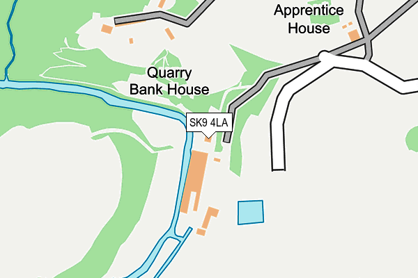
SK9 4LA is located in the Wilmslow Lacey Green electoral ward, within the unitary authority of Cheshire East and the English Parliamentary constituency of Tatton. The Sub Integrated Care Board (ICB) Location is NHS Cheshire and Merseyside ICB - 27D and the police force is Cheshire. This postcode has been in use since January 1980.


GetTheData
Source: OS OpenMap – Local (Ordnance Survey)
Source: OS VectorMap District (Ordnance Survey)
Licence: Open Government Licence (requires attribution)
| Easting | 383462 |
| Northing | 383065 |
| Latitude | 53.344235 |
| Longitude | -2.249865 |
GetTheData
Source: Open Postcode Geo
Licence: Open Government Licence
| Country | England |
| Postcode District | SK9 |
➜ See where SK9 is on a map | |
GetTheData
Source: Land Registry Price Paid Data
Licence: Open Government Licence
Elevation or altitude of SK9 4LA as distance above sea level:
| Metres | Feet | |
|---|---|---|
| Elevation | 60m | 197ft |
Elevation is measured from the approximate centre of the postcode, to the nearest point on an OS contour line from OS Terrain 50, which has contour spacing of ten vertical metres.
➜ How high above sea level am I? Find the elevation of your current position using your device's GPS.
GetTheData
Source: Open Postcode Elevation
Licence: Open Government Licence
| Ward | Wilmslow Lacey Green |
| Constituency | Tatton |
GetTheData
Source: ONS Postcode Database
Licence: Open Government Licence
| Quarry Bank Mill (Quarry Bank Road) | Styal | 150m |
| Hm Prison (Styal Road) | Styal | 677m |
| Hm Prison (Styal Road) | Styal | 692m |
| Altrincham Road (Hollin Lane) | Styal | 711m |
| Altrincham Road (Hollin Lane) | Styal | 726m |
| Styal Station | 0.8km |
| Handforth Station | 2.4km |
| Wilmslow Station | 2.5km |
GetTheData
Source: NaPTAN
Licence: Open Government Licence
| Percentage of properties with Next Generation Access | 100.0% |
| Percentage of properties with Superfast Broadband | 50.0% |
| Percentage of properties with Ultrafast Broadband | 0.0% |
| Percentage of properties with Full Fibre Broadband | 0.0% |
Superfast Broadband is between 30Mbps and 300Mbps
Ultrafast Broadband is > 300Mbps
| Percentage of properties unable to receive 2Mbps | 0.0% |
| Percentage of properties unable to receive 5Mbps | 0.0% |
| Percentage of properties unable to receive 10Mbps | 0.0% |
| Percentage of properties unable to receive 30Mbps | 50.0% |
GetTheData
Source: Ofcom
Licence: Ofcom Terms of Use (requires attribution)
GetTheData
Source: ONS Postcode Database
Licence: Open Government Licence


➜ Get more ratings from the Food Standards Agency
GetTheData
Source: Food Standards Agency
Licence: FSA terms & conditions
| Last Collection | |||
|---|---|---|---|
| Location | Mon-Fri | Sat | Distance |
| Civic Centre | 17:30 | 12:00 | 278m |
| Styal | 17:30 | 11:30 | 599m |
| Kings Road | 17:00 | 11:30 | 1,222m |
GetTheData
Source: Dracos
Licence: Creative Commons Attribution-ShareAlike
The below table lists the International Territorial Level (ITL) codes (formerly Nomenclature of Territorial Units for Statistics (NUTS) codes) and Local Administrative Units (LAU) codes for SK9 4LA:
| ITL 1 Code | Name |
|---|---|
| TLD | North West (England) |
| ITL 2 Code | Name |
| TLD6 | Cheshire |
| ITL 3 Code | Name |
| TLD62 | Cheshire East |
| LAU 1 Code | Name |
| E06000049 | Cheshire East |
GetTheData
Source: ONS Postcode Directory
Licence: Open Government Licence
The below table lists the Census Output Area (OA), Lower Layer Super Output Area (LSOA), and Middle Layer Super Output Area (MSOA) for SK9 4LA:
| Code | Name | |
|---|---|---|
| OA | E00174371 | |
| LSOA | E01018651 | Cheshire East 007F |
| MSOA | E02003859 | Cheshire East 007 |
GetTheData
Source: ONS Postcode Directory
Licence: Open Government Licence
| SK9 4JG | Quarry Bank Road | 214m |
| SK9 4JE | Altrincham Road | 512m |
| SK9 4HA | Clarendon Cottages | 693m |
| SK9 4LH | Altrincham Road | 717m |
| SK9 4JW | Station Road | 727m |
| SK9 4JH | Hollin Lane | 795m |
| SK9 4HW | Styal Road | 854m |
| SK9 4LY | Altrincham Road | 916m |
| SK9 5QB | Woodlands Road | 920m |
| SK9 4JP | Station Road | 1005m |
GetTheData
Source: Open Postcode Geo; Land Registry Price Paid Data
Licence: Open Government Licence