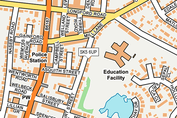
SK5 6UP lies on Harcourt Street in Stockport. SK5 6UP is located in the Reddish North electoral ward, within the metropolitan district of Stockport and the English Parliamentary constituency of Denton and Reddish. The Sub Integrated Care Board (ICB) Location is NHS Greater Manchester ICB - 01W and the police force is Greater Manchester. This postcode has been in use since January 1980.


GetTheData
Source: OS OpenMap – Local (Ordnance Survey)
Source: OS VectorMap District (Ordnance Survey)
Licence: Open Government Licence (requires attribution)
| Easting | 389792 |
| Northing | 394097 |
| Latitude | 53.443542 |
| Longitude | -2.155149 |
GetTheData
Source: Open Postcode Geo
Licence: Open Government Licence
| Street | Harcourt Street |
| Town/City | Stockport |
| Country | England |
| Postcode District | SK5 |
➜ See where SK5 is on a map ➜ Where is Reddish? | |
GetTheData
Source: Land Registry Price Paid Data
Licence: Open Government Licence
Elevation or altitude of SK5 6UP as distance above sea level:
| Metres | Feet | |
|---|---|---|
| Elevation | 80m | 262ft |
Elevation is measured from the approximate centre of the postcode, to the nearest point on an OS contour line from OS Terrain 50, which has contour spacing of ten vertical metres.
➜ How high above sea level am I? Find the elevation of your current position using your device's GPS.
GetTheData
Source: Open Postcode Elevation
Licence: Open Government Licence
| Ward | Reddish North |
| Constituency | Denton And Reddish |
GetTheData
Source: ONS Postcode Database
Licence: Open Government Licence
| Gorton Rd/Mill Ln (Gorton Rd) | Reddish | 148m |
| Gorton Rd/Mill Ln (Gorton Rd) | Reddish | 158m |
| Longford Rd/Junior Sch (Longford Rd Ea.) | North Reddish | 171m |
| Windmill Ln/Mill Ln (Windmill Ln) | North Reddish | 202m |
| Windmill Ln/Heswall Rd (Windmill Ln) | North Reddish | 237m |
| Reddish North Station | 0.7km |
| Reddish South Station | 0.9km |
| Brinnington Station | 1.8km |
GetTheData
Source: NaPTAN
Licence: Open Government Licence
| Percentage of properties with Next Generation Access | 100.0% |
| Percentage of properties with Superfast Broadband | 100.0% |
| Percentage of properties with Ultrafast Broadband | 100.0% |
| Percentage of properties with Full Fibre Broadband | 0.0% |
Superfast Broadband is between 30Mbps and 300Mbps
Ultrafast Broadband is > 300Mbps
| Median download speed | 76.8Mbps |
| Average download speed | 65.0Mbps |
| Maximum download speed | 350.00Mbps |
| Median upload speed | 10.0Mbps |
| Average upload speed | 11.7Mbps |
| Maximum upload speed | 20.00Mbps |
| Percentage of properties unable to receive 2Mbps | 0.0% |
| Percentage of properties unable to receive 5Mbps | 0.0% |
| Percentage of properties unable to receive 10Mbps | 0.0% |
| Percentage of properties unable to receive 30Mbps | 0.0% |
GetTheData
Source: Ofcom
Licence: Ofcom Terms of Use (requires attribution)
Estimated total energy consumption in SK5 6UP by fuel type, 2015.
| Consumption (kWh) | 335,557 |
|---|---|
| Meter count | 25 |
| Mean (kWh/meter) | 13,422 |
| Median (kWh/meter) | 12,137 |
| Consumption (kWh) | 84,106 |
|---|---|
| Meter count | 23 |
| Mean (kWh/meter) | 3,657 |
| Median (kWh/meter) | 3,998 |
GetTheData
Source: Postcode level gas estimates: 2015 (experimental)
Source: Postcode level electricity estimates: 2015 (experimental)
Licence: Open Government Licence
GetTheData
Source: ONS Postcode Database
Licence: Open Government Licence


➜ Get more ratings from the Food Standards Agency
GetTheData
Source: Food Standards Agency
Licence: FSA terms & conditions
| Last Collection | |||
|---|---|---|---|
| Location | Mon-Fri | Sat | Distance |
| Asquith Street | 17:15 | 12:15 | 159m |
| Mill Lane | 17:15 | 12:00 | 346m |
| Betley Road | 17:15 | 12:00 | 371m |
GetTheData
Source: Dracos
Licence: Creative Commons Attribution-ShareAlike
The below table lists the International Territorial Level (ITL) codes (formerly Nomenclature of Territorial Units for Statistics (NUTS) codes) and Local Administrative Units (LAU) codes for SK5 6UP:
| ITL 1 Code | Name |
|---|---|
| TLD | North West (England) |
| ITL 2 Code | Name |
| TLD3 | Greater Manchester |
| ITL 3 Code | Name |
| TLD35 | Greater Manchester South East |
| LAU 1 Code | Name |
| E08000007 | Stockport |
GetTheData
Source: ONS Postcode Directory
Licence: Open Government Licence
The below table lists the Census Output Area (OA), Lower Layer Super Output Area (LSOA), and Middle Layer Super Output Area (MSOA) for SK5 6UP:
| Code | Name | |
|---|---|---|
| OA | E00029835 | |
| LSOA | E01005889 | Stockport 001C |
| MSOA | E02001187 | Stockport 001 |
GetTheData
Source: ONS Postcode Directory
Licence: Open Government Licence
| SK5 6US | Burnham Avenue | 80m |
| SK5 6UU | Mill Lane | 93m |
| SK5 6UR | Asquith Street | 105m |
| SK5 6UN | Harcourt Street | 105m |
| SK5 6UZ | Tyrrell Road | 126m |
| SK5 6UX | Longford Road | 146m |
| SK5 6UW | Balfour Grove | 153m |
| SK5 6XA | Welland Street | 159m |
| SK5 6XD | Gorton Road | 169m |
| SK5 6YG | Deepdale Close | 190m |
GetTheData
Source: Open Postcode Geo; Land Registry Price Paid Data
Licence: Open Government Licence