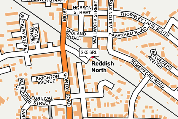
SK5 6RL is located in the Reddish North electoral ward, within the metropolitan district of Stockport and the English Parliamentary constituency of Denton and Reddish. The Sub Integrated Care Board (ICB) Location is NHS Greater Manchester ICB - 01W and the police force is Greater Manchester. This postcode has been in use since December 1997.


GetTheData
Source: OS OpenMap – Local (Ordnance Survey)
Source: OS VectorMap District (Ordnance Survey)
Licence: Open Government Licence (requires attribution)
| Easting | 389712 |
| Northing | 394749 |
| Latitude | 53.449401 |
| Longitude | -2.156375 |
GetTheData
Source: Open Postcode Geo
Licence: Open Government Licence
| Country | England |
| Postcode District | SK5 |
➜ See where SK5 is on a map ➜ Where is Reddish? | |
GetTheData
Source: Land Registry Price Paid Data
Licence: Open Government Licence
Elevation or altitude of SK5 6RL as distance above sea level:
| Metres | Feet | |
|---|---|---|
| Elevation | 80m | 262ft |
Elevation is measured from the approximate centre of the postcode, to the nearest point on an OS contour line from OS Terrain 50, which has contour spacing of ten vertical metres.
➜ How high above sea level am I? Find the elevation of your current position using your device's GPS.
GetTheData
Source: Open Postcode Elevation
Licence: Open Government Licence
| Ward | Reddish North |
| Constituency | Denton And Reddish |
GetTheData
Source: ONS Postcode Database
Licence: Open Government Licence
| Gorton Rd/North Reddish P.o. (Gorton Rd) | North Reddish | 91m |
| Gorton Rd/Ashbrook Ln (Gorton Rd) | North Reddish | 120m |
| Gorton Rd/Spey House (Gorton Rd) | North Reddish | 199m |
| Thornley Ln South/Wilton St (Thornley Ln Sth) | North Reddish | 210m |
| Gorton Rd/Spey House (Gorton Rd) | North Reddish | 212m |
| Reddish North Station | 0km |
| Ryder Brow Station | 1.4km |
| Reddish South Station | 1.5km |
GetTheData
Source: NaPTAN
Licence: Open Government Licence
Estimated total energy consumption in SK5 6RL by fuel type, 2015.
| Consumption (kWh) | 141,475 |
|---|---|
| Meter count | 14 |
| Mean (kWh/meter) | 10,105 |
| Median (kWh/meter) | 9,630 |
GetTheData
Source: Postcode level gas estimates: 2015 (experimental)
Source: Postcode level electricity estimates: 2015 (experimental)
Licence: Open Government Licence
GetTheData
Source: ONS Postcode Database
Licence: Open Government Licence


➜ Get more ratings from the Food Standards Agency
GetTheData
Source: Food Standards Agency
Licence: FSA terms & conditions
| Last Collection | |||
|---|---|---|---|
| Location | Mon-Fri | Sat | Distance |
| North Reddish Tso | 17:15 | 12:15 | 87m |
| Betley Road | 17:15 | 12:00 | 314m |
| Bulls Head | 17:30 | 11:45 | 374m |
GetTheData
Source: Dracos
Licence: Creative Commons Attribution-ShareAlike
The below table lists the International Territorial Level (ITL) codes (formerly Nomenclature of Territorial Units for Statistics (NUTS) codes) and Local Administrative Units (LAU) codes for SK5 6RL:
| ITL 1 Code | Name |
|---|---|
| TLD | North West (England) |
| ITL 2 Code | Name |
| TLD3 | Greater Manchester |
| ITL 3 Code | Name |
| TLD35 | Greater Manchester South East |
| LAU 1 Code | Name |
| E08000007 | Stockport |
GetTheData
Source: ONS Postcode Directory
Licence: Open Government Licence
The below table lists the Census Output Area (OA), Lower Layer Super Output Area (LSOA), and Middle Layer Super Output Area (MSOA) for SK5 6RL:
| Code | Name | |
|---|---|---|
| OA | E00029815 | |
| LSOA | E01005886 | Stockport 001A |
| MSOA | E02001187 | Stockport 001 |
GetTheData
Source: ONS Postcode Directory
Licence: Open Government Licence
| SK5 6PZ | Rydal Mount | 57m |
| SK5 6RY | Criterion Street | 66m |
| SK5 6RS | Gorton Road | 81m |
| SK5 6PY | Midland Road | 99m |
| SK5 6LR | Gorton Road | 109m |
| SK5 6FS | Ashford Court | 119m |
| SK5 6RP | Ashbrook Farm Close | 128m |
| SK5 6PT | Hobson Street | 148m |
| SK5 6NP | Everton Road | 157m |
| SK5 6QN | Davenham Road | 161m |
GetTheData
Source: Open Postcode Geo; Land Registry Price Paid Data
Licence: Open Government Licence