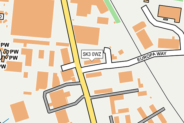
SK3 0WZ is located in the Cheadle East & Cheadle Hulme North electoral ward, within the metropolitan district of Stockport and the English Parliamentary constituency of Stockport. The Sub Integrated Care Board (ICB) Location is NHS Greater Manchester ICB - 01W and the police force is Greater Manchester. This postcode has been in use since December 1997.


GetTheData
Source: OS OpenMap – Local (Ordnance Survey)
Source: OS VectorMap District (Ordnance Survey)
Licence: Open Government Licence (requires attribution)
| Easting | 387829 |
| Northing | 388662 |
| Latitude | 53.394647 |
| Longitude | -2.184491 |
GetTheData
Source: Open Postcode Geo
Licence: Open Government Licence
| Country | England |
| Postcode District | SK3 |
➜ See where SK3 is on a map ➜ Where is Stockport? | |
GetTheData
Source: Land Registry Price Paid Data
Licence: Open Government Licence
Elevation or altitude of SK3 0WZ as distance above sea level:
| Metres | Feet | |
|---|---|---|
| Elevation | 50m | 164ft |
Elevation is measured from the approximate centre of the postcode, to the nearest point on an OS contour line from OS Terrain 50, which has contour spacing of ten vertical metres.
➜ How high above sea level am I? Find the elevation of your current position using your device's GPS.
GetTheData
Source: Open Postcode Elevation
Licence: Open Government Licence
| Ward | Cheadle East & Cheadle Hulme North |
| Constituency | Stockport |
GetTheData
Source: ONS Postcode Database
Licence: Open Government Licence
| Bird Hall Ln/Fielding Works (Bird Hall Ln) | Adswood | 107m |
| Bird Hall Ln/Orion Business Pk (Bird Hall Ln) | Adswood | 156m |
| Bird Hall Ln/Fielding Works (Bird Hall Ln) | Adswood | 192m |
| Bird Hall Ln/Orion Business Park (Bird Hall Ln) | Adswood | 277m |
| Edgeley Rd/Cheadle Old Rd (Edgeley Rd) | Edgeley | 483m |
| Stockport Station | 1.9km |
| Cheadle Hulme Station | 2.1km |
| Davenport Station | 2.1km |
GetTheData
Source: NaPTAN
Licence: Open Government Licence
GetTheData
Source: ONS Postcode Database
Licence: Open Government Licence


➜ Get more ratings from the Food Standards Agency
GetTheData
Source: Food Standards Agency
Licence: FSA terms & conditions
| Last Collection | |||
|---|---|---|---|
| Location | Mon-Fri | Sat | Distance |
| Edgeley Road | 17:30 | 11:45 | 494m |
| Bird Hall Lane | 17:30 | 11:45 | 499m |
| Heathside Road | 17:30 | 12:00 | 671m |
GetTheData
Source: Dracos
Licence: Creative Commons Attribution-ShareAlike
The below table lists the International Territorial Level (ITL) codes (formerly Nomenclature of Territorial Units for Statistics (NUTS) codes) and Local Administrative Units (LAU) codes for SK3 0WZ:
| ITL 1 Code | Name |
|---|---|
| TLD | North West (England) |
| ITL 2 Code | Name |
| TLD3 | Greater Manchester |
| ITL 3 Code | Name |
| TLD35 | Greater Manchester South East |
| LAU 1 Code | Name |
| E08000007 | Stockport |
GetTheData
Source: ONS Postcode Directory
Licence: Open Government Licence
The below table lists the Census Output Area (OA), Lower Layer Super Output Area (LSOA), and Middle Layer Super Output Area (MSOA) for SK3 0WZ:
| Code | Name | |
|---|---|---|
| OA | E00029198 | |
| LSOA | E01005762 | Stockport 026B |
| MSOA | E02001212 | Stockport 026 |
GetTheData
Source: ONS Postcode Directory
Licence: Open Government Licence
| SK3 0XN | Bird Hall Lane | 171m |
| SK3 0UX | Hercules Office Park | 232m |
| SK3 0US | Florence Court | 279m |
| SK3 0TW | Willdor Grove | 310m |
| SK3 9RN | The Circuit | 352m |
| SK3 0SQ | Tewkesbury Road | 355m |
| SK8 2EU | Ingle Road | 356m |
| SK3 0TN | Naples Road | 359m |
| SK3 0TA | Royon Drive | 360m |
| SK3 0TP | Bilson Drive | 369m |
GetTheData
Source: Open Postcode Geo; Land Registry Price Paid Data
Licence: Open Government Licence