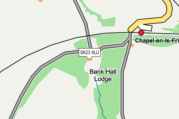
SK23 9UJ is located in the Chapel West electoral ward, within the local authority district of High Peak and the English Parliamentary constituency of High Peak. The Sub Integrated Care Board (ICB) Location is NHS Derby and Derbyshire ICB - 15M and the police force is Derbyshire. This postcode has been in use since December 1996.


GetTheData
Source: OS OpenMap – Local (Ordnance Survey)
Source: OS VectorMap District (Ordnance Survey)
Licence: Open Government Licence (requires attribution)
| Easting | 405332 |
| Northing | 379375 |
| Latitude | 53.311287 |
| Longitude | -1.921436 |
GetTheData
Source: Open Postcode Geo
Licence: Open Government Licence
| Country | England |
| Postcode District | SK23 |
➜ See where SK23 is on a map | |
GetTheData
Source: Land Registry Price Paid Data
Licence: Open Government Licence
Elevation or altitude of SK23 9UJ as distance above sea level:
| Metres | Feet | |
|---|---|---|
| Elevation | 270m | 886ft |
Elevation is measured from the approximate centre of the postcode, to the nearest point on an OS contour line from OS Terrain 50, which has contour spacing of ten vertical metres.
➜ How high above sea level am I? Find the elevation of your current position using your device's GPS.
GetTheData
Source: Open Postcode Elevation
Licence: Open Government Licence
| Ward | Chapel West |
| Constituency | High Peak |
GetTheData
Source: ONS Postcode Database
Licence: Open Government Licence
| High School Bus Park (Bus Park) | Chapel En Le Frith | 872m |
| High School (Long Lane) | Chapel En Le Frith | 1,021m |
| High School (Long Lane) | Chapel En Le Frith | 1,026m |
| Eccles Fold (Manchester Road) | Chapel En Le Frith | 1,105m |
| Eccles Fold (Manchester Road) | Chapel En Le Frith | 1,123m |
| Chapel-en-le-Frith Station | 0.2km |
| Dove Holes Station | 2.5km |
| Chinley Station | 3.6km |
GetTheData
Source: NaPTAN
Licence: Open Government Licence
| Percentage of properties with Next Generation Access | 100.0% |
| Percentage of properties with Superfast Broadband | 100.0% |
| Percentage of properties with Ultrafast Broadband | 0.0% |
| Percentage of properties with Full Fibre Broadband | 0.0% |
Superfast Broadband is between 30Mbps and 300Mbps
Ultrafast Broadband is > 300Mbps
| Percentage of properties unable to receive 2Mbps | 0.0% |
| Percentage of properties unable to receive 5Mbps | 0.0% |
| Percentage of properties unable to receive 10Mbps | 0.0% |
| Percentage of properties unable to receive 30Mbps | 0.0% |
GetTheData
Source: Ofcom
Licence: Ofcom Terms of Use (requires attribution)
GetTheData
Source: ONS Postcode Database
Licence: Open Government Licence


➜ Get more ratings from the Food Standards Agency
GetTheData
Source: Food Standards Agency
Licence: FSA terms & conditions
| Last Collection | |||
|---|---|---|---|
| Location | Mon-Fri | Sat | Distance |
| Rowton Grange | 17:30 | 07:45 | 711m |
| Hordens Road | 17:15 | 10:15 | 1,021m |
| Grange Park Avenue | 17:30 | 10:15 | 1,073m |
GetTheData
Source: Dracos
Licence: Creative Commons Attribution-ShareAlike
The below table lists the International Territorial Level (ITL) codes (formerly Nomenclature of Territorial Units for Statistics (NUTS) codes) and Local Administrative Units (LAU) codes for SK23 9UJ:
| ITL 1 Code | Name |
|---|---|
| TLF | East Midlands (England) |
| ITL 2 Code | Name |
| TLF1 | Derbyshire and Nottinghamshire |
| ITL 3 Code | Name |
| TLF13 | South and West Derbyshire |
| LAU 1 Code | Name |
| E07000037 | High Peak |
GetTheData
Source: ONS Postcode Directory
Licence: Open Government Licence
The below table lists the Census Output Area (OA), Lower Layer Super Output Area (LSOA), and Middle Layer Super Output Area (MSOA) for SK23 9UJ:
| Code | Name | |
|---|---|---|
| OA | E00099784 | |
| LSOA | E01019721 | High Peak 013H |
| MSOA | E02006872 | High Peak 013 |
GetTheData
Source: ONS Postcode Directory
Licence: Open Government Licence
| SK23 9UB | Bankhall | 460m |
| SK23 0XT | Bridgeway | 583m |
| SK23 0UE | Beckets Wood | 631m |
| SK23 0XU | Hawthorn Road | 642m |
| SK23 0XS | Sycamore Road | 643m |
| SK23 9UD | 672m | |
| SK23 0LY | Gisbourne Drive | 674m |
| SK23 0XP | Longmeade Drive | 676m |
| SK23 9UQ | Marsh Hall Lane | 683m |
| SK23 0UB | Canterbury Place | 697m |
GetTheData
Source: Open Postcode Geo; Land Registry Price Paid Data
Licence: Open Government Licence