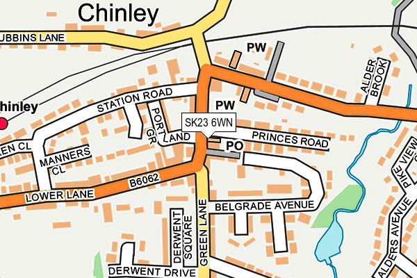
SK23 6WN is located in the Blackbrook electoral ward, within the local authority district of High Peak and the English Parliamentary constituency of High Peak. The Sub Integrated Care Board (ICB) Location is NHS Derby and Derbyshire ICB - 15M and the police force is Derbyshire. This postcode has been in use since October 2009.


GetTheData
Source: OS OpenMap – Local (Ordnance Survey)
Source: OS VectorMap District (Ordnance Survey)
Licence: Open Government Licence (requires attribution)
| Easting | 404106 |
| Northing | 382559 |
| Latitude | 53.339934 |
| Longitude | -1.939795 |
GetTheData
Source: Open Postcode Geo
Licence: Open Government Licence
| Country | England |
| Postcode District | SK23 |
➜ See where SK23 is on a map ➜ Where is Chinley? | |
GetTheData
Source: Land Registry Price Paid Data
Licence: Open Government Licence
Elevation or altitude of SK23 6WN as distance above sea level:
| Metres | Feet | |
|---|---|---|
| Elevation | 200m | 656ft |
Elevation is measured from the approximate centre of the postcode, to the nearest point on an OS contour line from OS Terrain 50, which has contour spacing of ten vertical metres.
➜ How high above sea level am I? Find the elevation of your current position using your device's GPS.
GetTheData
Source: Open Postcode Elevation
Licence: Open Government Licence
| Ward | Blackbrook |
| Constituency | High Peak |
GetTheData
Source: ONS Postcode Database
Licence: Open Government Licence
| Station Road | Chinley | 89m |
| Lower Lane | Chinley | 213m |
| Lower Lane | Chinley | 278m |
| Alders Avenue (Buxton Road) | Chinley | 404m |
| Alders Avenue (Buxton Road) | Chinley | 405m |
| Chinley Station | 0.3km |
| Whaley Bridge Station | 3.2km |
| Chapel-en-le-Frith Station | 3.4km |
GetTheData
Source: NaPTAN
Licence: Open Government Licence
GetTheData
Source: ONS Postcode Database
Licence: Open Government Licence


➜ Get more ratings from the Food Standards Agency
GetTheData
Source: Food Standards Agency
Licence: FSA terms & conditions
| Last Collection | |||
|---|---|---|---|
| Location | Mon-Fri | Sat | Distance |
| Green Lane | 18:00 | 11:00 | 16m |
| White Hough | 17:45 | 09:15 | 590m |
| Leaden Knowle | 17:30 | 09:00 | 796m |
GetTheData
Source: Dracos
Licence: Creative Commons Attribution-ShareAlike
The below table lists the International Territorial Level (ITL) codes (formerly Nomenclature of Territorial Units for Statistics (NUTS) codes) and Local Administrative Units (LAU) codes for SK23 6WN:
| ITL 1 Code | Name |
|---|---|
| TLF | East Midlands (England) |
| ITL 2 Code | Name |
| TLF1 | Derbyshire and Nottinghamshire |
| ITL 3 Code | Name |
| TLF13 | South and West Derbyshire |
| LAU 1 Code | Name |
| E07000037 | High Peak |
GetTheData
Source: ONS Postcode Directory
Licence: Open Government Licence
The below table lists the Census Output Area (OA), Lower Layer Super Output Area (LSOA), and Middle Layer Super Output Area (MSOA) for SK23 6WN:
| Code | Name | |
|---|---|---|
| OA | E00099742 | |
| LSOA | E01019711 | High Peak 006A |
| MSOA | E02004098 | High Peak 006 |
GetTheData
Source: ONS Postcode Directory
Licence: Open Government Licence
| SK23 6AX | Portland Grove | 24m |
| SK23 6BA | Green Lane | 24m |
| SK23 6BB | Belle Vue | 35m |
| SK23 6AA | Green Lane | 42m |
| SK23 6AD | Portland Grove | 72m |
| SK23 6EL | Buxton Road | 85m |
| SK23 6BR | Green Lane | 88m |
| SK23 6EG | St Marys Close | 94m |
| SK23 6DE | The Sidings | 110m |
| SK23 6AS | Devonshire Drive | 118m |
GetTheData
Source: Open Postcode Geo; Land Registry Price Paid Data
Licence: Open Government Licence