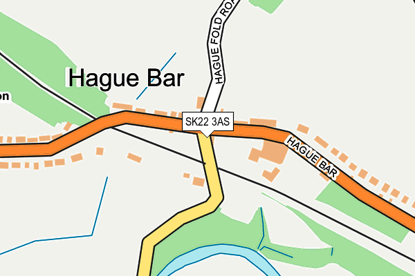
SK22 3AS lies on Waterside Road in New Mills, High Peak. SK22 3AS is located in the New Mills West electoral ward, within the local authority district of High Peak and the English Parliamentary constituency of High Peak. The Sub Integrated Care Board (ICB) Location is NHS Derby and Derbyshire ICB - 15M and the police force is Derbyshire. This postcode has been in use since December 1996.


GetTheData
Source: OS OpenMap – Local (Ordnance Survey)
Source: OS VectorMap District (Ordnance Survey)
Licence: Open Government Licence (requires attribution)
| Easting | 398604 |
| Northing | 385705 |
| Latitude | 53.368209 |
| Longitude | -2.022443 |
GetTheData
Source: Open Postcode Geo
Licence: Open Government Licence
| Street | Waterside Road |
| Locality | New Mills |
| Town/City | High Peak |
| Country | England |
| Postcode District | SK22 |
➜ See where SK22 is on a map ➜ Where is Hague Bar? | |
GetTheData
Source: Land Registry Price Paid Data
Licence: Open Government Licence
Elevation or altitude of SK22 3AS as distance above sea level:
| Metres | Feet | |
|---|---|---|
| Elevation | 140m | 459ft |
Elevation is measured from the approximate centre of the postcode, to the nearest point on an OS contour line from OS Terrain 50, which has contour spacing of ten vertical metres.
➜ How high above sea level am I? Find the elevation of your current position using your device's GPS.
GetTheData
Source: Open Postcode Elevation
Licence: Open Government Licence
| Ward | New Mills West |
| Constituency | High Peak |
GetTheData
Source: ONS Postcode Database
Licence: Open Government Licence
| Waterside Road (Hague Bar Road) | Hague Bar | 24m |
| Waterside Road (Hague Bar Road) | Hague Bar | 31m |
| Primary School (Lower Hague) | Hague Bar | 272m |
| White Gate House (Hague Bar Road) | Hague Bar | 296m |
| Primary School (Lower Hague) | Hague Bar | 297m |
| Strines Station | 1.1km |
| New Mills Central Station | 1.2km |
| New Mills Newtown Station | 1.3km |
GetTheData
Source: NaPTAN
Licence: Open Government Licence
| Percentage of properties with Next Generation Access | 100.0% |
| Percentage of properties with Superfast Broadband | 0.0% |
| Percentage of properties with Ultrafast Broadband | 0.0% |
| Percentage of properties with Full Fibre Broadband | 0.0% |
Superfast Broadband is between 30Mbps and 300Mbps
Ultrafast Broadband is > 300Mbps
| Median download speed | 15.7Mbps |
| Average download speed | 15.4Mbps |
| Maximum download speed | 20.80Mbps |
| Median upload speed | 1.2Mbps |
| Average upload speed | 1.1Mbps |
| Maximum upload speed | 1.26Mbps |
| Percentage of properties unable to receive 2Mbps | 0.0% |
| Percentage of properties unable to receive 5Mbps | 0.0% |
| Percentage of properties unable to receive 10Mbps | 0.0% |
| Percentage of properties unable to receive 30Mbps | 100.0% |
GetTheData
Source: Ofcom
Licence: Ofcom Terms of Use (requires attribution)
GetTheData
Source: ONS Postcode Database
Licence: Open Government Licence


➜ Get more ratings from the Food Standards Agency
GetTheData
Source: Food Standards Agency
Licence: FSA terms & conditions
| Last Collection | |||
|---|---|---|---|
| Location | Mon-Fri | Sat | Distance |
| Hague Bar | 17:45 | 11:00 | 27m |
| Brookbottom | 09:30 | 09:30 | 706m |
| High Lee Eaves, Knoll Road | 17:30 | 11:45 | 1,047m |
GetTheData
Source: Dracos
Licence: Creative Commons Attribution-ShareAlike
The below table lists the International Territorial Level (ITL) codes (formerly Nomenclature of Territorial Units for Statistics (NUTS) codes) and Local Administrative Units (LAU) codes for SK22 3AS:
| ITL 1 Code | Name |
|---|---|
| TLF | East Midlands (England) |
| ITL 2 Code | Name |
| TLF1 | Derbyshire and Nottinghamshire |
| ITL 3 Code | Name |
| TLF13 | South and West Derbyshire |
| LAU 1 Code | Name |
| E07000037 | High Peak |
GetTheData
Source: ONS Postcode Directory
Licence: Open Government Licence
The below table lists the Census Output Area (OA), Lower Layer Super Output Area (LSOA), and Middle Layer Super Output Area (MSOA) for SK22 3AS:
| Code | Name | |
|---|---|---|
| OA | E00099912 | |
| LSOA | E01019747 | High Peak 005B |
| MSOA | E02004097 | High Peak 005 |
GetTheData
Source: ONS Postcode Directory
Licence: Open Government Licence
| SK22 3AU | Hague Fold | 50m |
| SK22 3AR | Hague Bar | 84m |
| SK22 3AT | Hague Bar | 163m |
| SK22 3AX | Hague Fold | 292m |
| SK22 3AP | Lower Hague | 315m |
| SK22 3DY | Brookbottom Road | 439m |
| SK22 3DX | Larkhill | 540m |
| SK12 2HJ | Waterside | 576m |
| SK22 3DU | Larkhill Terrace | 623m |
| SK12 2HL | Redhouse Lane | 634m |
GetTheData
Source: Open Postcode Geo; Land Registry Price Paid Data
Licence: Open Government Licence