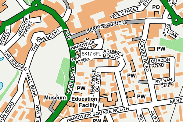
SK17 6PL lies on Hardwick Gardens in Buxton. SK17 6PL is located in the Buxton Central electoral ward, within the local authority district of High Peak and the English Parliamentary constituency of High Peak. The Sub Integrated Care Board (ICB) Location is NHS Derby and Derbyshire ICB - 15M and the police force is Derbyshire. This postcode has been in use since June 2000.


GetTheData
Source: OS OpenMap – Local (Ordnance Survey)
Source: OS VectorMap District (Ordnance Survey)
Licence: Open Government Licence (requires attribution)
| Easting | 405974 |
| Northing | 373466 |
| Latitude | 53.258166 |
| Longitude | -1.911909 |
GetTheData
Source: Open Postcode Geo
Licence: Open Government Licence
| Street | Hardwick Gardens |
| Town/City | Buxton |
| Country | England |
| Postcode District | SK17 |
➜ See where SK17 is on a map ➜ Where is Buxton? | |
GetTheData
Source: Land Registry Price Paid Data
Licence: Open Government Licence
Elevation or altitude of SK17 6PL as distance above sea level:
| Metres | Feet | |
|---|---|---|
| Elevation | 300m | 984ft |
Elevation is measured from the approximate centre of the postcode, to the nearest point on an OS contour line from OS Terrain 50, which has contour spacing of ten vertical metres.
➜ How high above sea level am I? Find the elevation of your current position using your device's GPS.
GetTheData
Source: Open Postcode Elevation
Licence: Open Government Licence
| Ward | Buxton Central |
| Constituency | High Peak |
GetTheData
Source: ONS Postcode Database
Licence: Open Government Licence
4, HARDWICK GARDENS, BUXTON, SK17 6PL 1999 26 NOV £58,750 |
GetTheData
Source: HM Land Registry Price Paid Data
Licence: Contains HM Land Registry data © Crown copyright and database right 2025. This data is licensed under the Open Government Licence v3.0.
| Terrace Road | Buxton | 69m |
| Terrace Road | Buxton | 77m |
| Colonnade (The Quadrant) | Buxton | 174m |
| Market Place | Buxton | 226m |
| Market Place (Terrace Road) | Buxton | 241m |
| Buxton Station | 0.3km |
| Dove Holes Station | 4.9km |
GetTheData
Source: NaPTAN
Licence: Open Government Licence
| Percentage of properties with Next Generation Access | 100.0% |
| Percentage of properties with Superfast Broadband | 100.0% |
| Percentage of properties with Ultrafast Broadband | 0.0% |
| Percentage of properties with Full Fibre Broadband | 0.0% |
Superfast Broadband is between 30Mbps and 300Mbps
Ultrafast Broadband is > 300Mbps
| Percentage of properties unable to receive 2Mbps | 0.0% |
| Percentage of properties unable to receive 5Mbps | 0.0% |
| Percentage of properties unable to receive 10Mbps | 0.0% |
| Percentage of properties unable to receive 30Mbps | 0.0% |
GetTheData
Source: Ofcom
Licence: Ofcom Terms of Use (requires attribution)
Estimated total energy consumption in SK17 6PL by fuel type, 2015.
| Consumption (kWh) | 24,675 |
|---|---|
| Meter count | 12 |
| Mean (kWh/meter) | 2,056 |
| Median (kWh/meter) | 2,328 |
GetTheData
Source: Postcode level gas estimates: 2015 (experimental)
Source: Postcode level electricity estimates: 2015 (experimental)
Licence: Open Government Licence
GetTheData
Source: ONS Postcode Database
Licence: Open Government Licence


➜ Get more ratings from the Food Standards Agency
GetTheData
Source: Food Standards Agency
Licence: FSA terms & conditions
| Last Collection | |||
|---|---|---|---|
| Location | Mon-Fri | Sat | Distance |
| Hardwick Mount | 17:30 | 11:15 | 54m |
| Town Hall | 17:30 | 11:15 | 163m |
| Quadrant | 18:00 | 12:30 | 174m |
GetTheData
Source: Dracos
Licence: Creative Commons Attribution-ShareAlike
The below table lists the International Territorial Level (ITL) codes (formerly Nomenclature of Territorial Units for Statistics (NUTS) codes) and Local Administrative Units (LAU) codes for SK17 6PL:
| ITL 1 Code | Name |
|---|---|
| TLF | East Midlands (England) |
| ITL 2 Code | Name |
| TLF1 | Derbyshire and Nottinghamshire |
| ITL 3 Code | Name |
| TLF13 | South and West Derbyshire |
| LAU 1 Code | Name |
| E07000037 | High Peak |
GetTheData
Source: ONS Postcode Directory
Licence: Open Government Licence
The below table lists the Census Output Area (OA), Lower Layer Super Output Area (LSOA), and Middle Layer Super Output Area (MSOA) for SK17 6PL:
| Code | Name | |
|---|---|---|
| OA | E00099752 | |
| LSOA | E01019717 | High Peak 010C |
| MSOA | E02004102 | High Peak 010 |
GetTheData
Source: ONS Postcode Directory
Licence: Open Government Licence
| SK17 6DH | Hardwick Street | 51m |
| SK17 6PP | Hardwick Mount | 62m |
| SK17 6PU | Hardwick Square North | 70m |
| SK17 6PX | Hardwick Square West | 71m |
| SK17 6DR | Terrace Road | 74m |
| SK17 6DE | Spring Gardens | 81m |
| SK17 6PN | Haddon Court | 86m |
| SK17 6DU | Terrace Road | 103m |
| SK17 6PS | Hardwick Mount | 113m |
| SK17 6PR | Hardwick Mount | 120m |
GetTheData
Source: Open Postcode Geo; Land Registry Price Paid Data
Licence: Open Government Licence