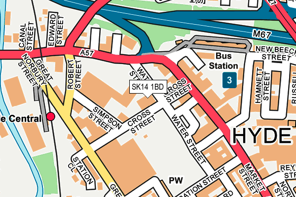
SK14 1BD lies on Water Street in Hyde. SK14 1BD is located in the Hyde Werneth electoral ward, within the metropolitan district of Tameside and the English Parliamentary constituency of Stalybridge and Hyde. The Sub Integrated Care Board (ICB) Location is NHS Greater Manchester ICB - 01Y and the police force is Greater Manchester. This postcode has been in use since January 1980.


GetTheData
Source: OS OpenMap – Local (Ordnance Survey)
Source: OS VectorMap District (Ordnance Survey)
Licence: Open Government Licence (requires attribution)
| Easting | 394643 |
| Northing | 395014 |
| Latitude | 53.451857 |
| Longitude | -2.082133 |
GetTheData
Source: Open Postcode Geo
Licence: Open Government Licence
| Street | Water Street |
| Town/City | Hyde |
| Country | England |
| Postcode District | SK14 |
➜ See where SK14 is on a map ➜ Where is Hyde? | |
GetTheData
Source: Land Registry Price Paid Data
Licence: Open Government Licence
Elevation or altitude of SK14 1BD as distance above sea level:
| Metres | Feet | |
|---|---|---|
| Elevation | 100m | 328ft |
Elevation is measured from the approximate centre of the postcode, to the nearest point on an OS contour line from OS Terrain 50, which has contour spacing of ten vertical metres.
➜ How high above sea level am I? Find the elevation of your current position using your device's GPS.
GetTheData
Source: Open Postcode Elevation
Licence: Open Government Licence
| Ward | Hyde Werneth |
| Constituency | Stalybridge And Hyde |
GetTheData
Source: ONS Postcode Database
Licence: Open Government Licence
| Market St/Cross St (Market St) | Hyde | 84m |
| Market St/Hyde Market Pl (Market Street) | Hyde | 205m |
| Market St/Hyde Market Place (Market St) | Hyde | 218m |
| New Beech St/Hyde Bus Stn (New Beech St) | Hyde | 227m |
| Market St/Last Orders (Market St) | Hyde | 239m |
| Hyde Central Station | 0.2km |
| Flowery Field Station | 1.1km |
| Newton for Hyde Station | 1.1km |
GetTheData
Source: NaPTAN
Licence: Open Government Licence
GetTheData
Source: ONS Postcode Database
Licence: Open Government Licence


➜ Get more ratings from the Food Standards Agency
GetTheData
Source: Food Standards Agency
Licence: FSA terms & conditions
| Last Collection | |||
|---|---|---|---|
| Location | Mon-Fri | Sat | Distance |
| Gt Norbury St | 18:30 | 11:30 | 250m |
| Hamnet Street | 18:00 | 12:30 | 252m |
| Market Street | 18:30 | 12:00 | 273m |
GetTheData
Source: Dracos
Licence: Creative Commons Attribution-ShareAlike
The below table lists the International Territorial Level (ITL) codes (formerly Nomenclature of Territorial Units for Statistics (NUTS) codes) and Local Administrative Units (LAU) codes for SK14 1BD:
| ITL 1 Code | Name |
|---|---|
| TLD | North West (England) |
| ITL 2 Code | Name |
| TLD3 | Greater Manchester |
| ITL 3 Code | Name |
| TLD35 | Greater Manchester South East |
| LAU 1 Code | Name |
| E08000008 | Tameside |
GetTheData
Source: ONS Postcode Directory
Licence: Open Government Licence
The below table lists the Census Output Area (OA), Lower Layer Super Output Area (LSOA), and Middle Layer Super Output Area (MSOA) for SK14 1BD:
| Code | Name | |
|---|---|---|
| OA | E00030628 | |
| LSOA | E01006040 | Tameside 028E |
| MSOA | E02001256 | Tameside 028 |
GetTheData
Source: ONS Postcode Directory
Licence: Open Government Licence
| SK14 1AY | Market Street | 66m |
| SK14 1EH | Milk Street | 68m |
| SK14 1BA | Manchester Road | 73m |
| SK14 2AD | Market Street | 99m |
| SK14 1AH | Market Street | 109m |
| SK14 2AB | Market Street | 128m |
| SK14 1SD | Birch Terrace | 181m |
| SK14 2EL | Clarendon Street | 208m |
| SK14 1AB | Corporation Street | 219m |
| SK14 1SF | Station Close | 220m |
GetTheData
Source: Open Postcode Geo; Land Registry Price Paid Data
Licence: Open Government Licence