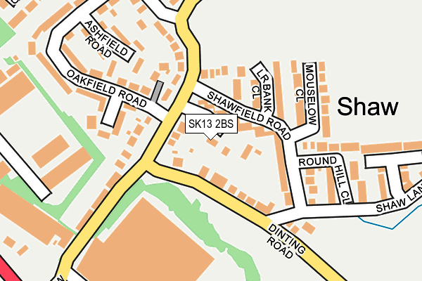
SK13 2BS lies on The Sycamores in Hadfield, Glossop. SK13 2BS is located in the Hadfield South electoral ward, within the local authority district of High Peak and the English Parliamentary constituency of High Peak. The Sub Integrated Care Board (ICB) Location is NHS Derby and Derbyshire ICB - 15M and the police force is Derbyshire. This postcode has been in use since December 1997.


GetTheData
Source: OS OpenMap – Local (Ordnance Survey)
Source: OS VectorMap District (Ordnance Survey)
Licence: Open Government Licence (requires attribution)
| Easting | 401652 |
| Northing | 395175 |
| Latitude | 53.453330 |
| Longitude | -1.976590 |
GetTheData
Source: Open Postcode Geo
Licence: Open Government Licence
| Street | The Sycamores |
| Locality | Hadfield |
| Town/City | Glossop |
| Country | England |
| Postcode District | SK13 |
➜ See where SK13 is on a map ➜ Where is Hadfield? | |
GetTheData
Source: Land Registry Price Paid Data
Licence: Open Government Licence
Elevation or altitude of SK13 2BS as distance above sea level:
| Metres | Feet | |
|---|---|---|
| Elevation | 140m | 459ft |
Elevation is measured from the approximate centre of the postcode, to the nearest point on an OS contour line from OS Terrain 50, which has contour spacing of ten vertical metres.
➜ How high above sea level am I? Find the elevation of your current position using your device's GPS.
GetTheData
Source: Open Postcode Elevation
Licence: Open Government Licence
| Ward | Hadfield South |
| Constituency | High Peak |
GetTheData
Source: ONS Postcode Database
Licence: Open Government Licence
2, THE SYCAMORES, HADFIELD, GLOSSOP, SK13 2BS 2018 23 MAR £258,000 |
1, THE SYCAMORES, HADFIELD, GLOSSOP, SK13 2BS 2002 1 FEB £185,000 |
1, THE SYCAMORES, HADFIELD, GLOSSOP, SK13 2BS 1998 10 AUG £107,000 |
GetTheData
Source: HM Land Registry Price Paid Data
Licence: Contains HM Land Registry data © Crown copyright and database right 2025. This data is licensed under the Open Government Licence v3.0.
| Newshaw Lane (Shaw Lane) | Hadfield | 63m |
| Newshaw Lane (Shaw Lane) | Hadfield | 65m |
| The Sycamores (Newshaw Lane) | Hadfield | 69m |
| The Sycamores (Newshaw Lane) | Hadfield | 76m |
| Thorncliffe Road (Newshaw Lane) | Hadfield | 216m |
| Dinting Station | 0.6km |
| Hadfield Station | 1.1km |
| Glossop Station | 2.1km |
GetTheData
Source: NaPTAN
Licence: Open Government Licence
| Percentage of properties with Next Generation Access | 100.0% |
| Percentage of properties with Superfast Broadband | 100.0% |
| Percentage of properties with Ultrafast Broadband | 0.0% |
| Percentage of properties with Full Fibre Broadband | 0.0% |
Superfast Broadband is between 30Mbps and 300Mbps
Ultrafast Broadband is > 300Mbps
| Median download speed | 40.0Mbps |
| Average download speed | 48.2Mbps |
| Maximum download speed | 80.00Mbps |
| Median upload speed | 19.5Mbps |
| Average upload speed | 14.0Mbps |
| Maximum upload speed | 20.00Mbps |
| Percentage of properties unable to receive 2Mbps | 0.0% |
| Percentage of properties unable to receive 5Mbps | 0.0% |
| Percentage of properties unable to receive 10Mbps | 0.0% |
| Percentage of properties unable to receive 30Mbps | 0.0% |
GetTheData
Source: Ofcom
Licence: Ofcom Terms of Use (requires attribution)
GetTheData
Source: ONS Postcode Database
Licence: Open Government Licence


➜ Get more ratings from the Food Standards Agency
GetTheData
Source: Food Standards Agency
Licence: FSA terms & conditions
| Last Collection | |||
|---|---|---|---|
| Location | Mon-Fri | Sat | Distance |
| Shaw Lane | 18:30 | 11:45 | 272m |
| Green Lane | 17:45 | 11:30 | 424m |
| Newlands Drive | 17:45 | 11:45 | 608m |
GetTheData
Source: Dracos
Licence: Creative Commons Attribution-ShareAlike
The below table lists the International Territorial Level (ITL) codes (formerly Nomenclature of Territorial Units for Statistics (NUTS) codes) and Local Administrative Units (LAU) codes for SK13 2BS:
| ITL 1 Code | Name |
|---|---|
| TLF | East Midlands (England) |
| ITL 2 Code | Name |
| TLF1 | Derbyshire and Nottinghamshire |
| ITL 3 Code | Name |
| TLF13 | South and West Derbyshire |
| LAU 1 Code | Name |
| E07000037 | High Peak |
GetTheData
Source: ONS Postcode Directory
Licence: Open Government Licence
The below table lists the Census Output Area (OA), Lower Layer Super Output Area (LSOA), and Middle Layer Super Output Area (MSOA) for SK13 2BS:
| Code | Name | |
|---|---|---|
| OA | E00099832 | |
| LSOA | E01019733 | High Peak 001A |
| MSOA | E02004093 | High Peak 001 |
GetTheData
Source: ONS Postcode Directory
Licence: Open Government Licence
| SK13 6EE | Shaw Lane | 75m |
| SK13 2BE | Shawfield Road | 75m |
| SK13 2BD | Newshaw Lane | 93m |
| SK13 2BJ | Shawfield Road | 121m |
| SK13 2BG | Lower Bank Close | 127m |
| SK13 2BW | Beechfield Road | 135m |
| SK13 2BQ | Mouselow Close | 173m |
| SK13 7UU | Dinting Road | 183m |
| SK13 6EF | Shaw Lane | 184m |
| SK13 2BP | Ashfield Road | 198m |
GetTheData
Source: Open Postcode Geo; Land Registry Price Paid Data
Licence: Open Government Licence