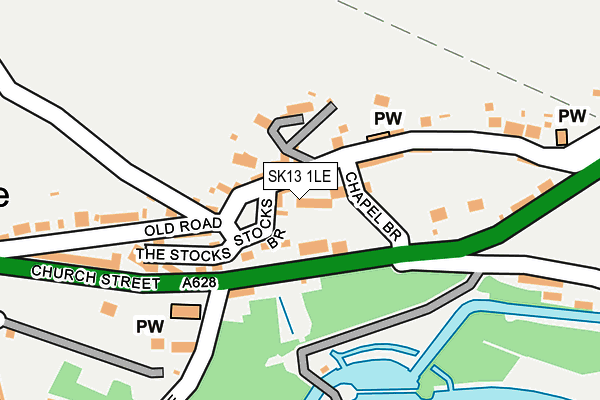
SK13 1LE lies on Lower Square in Tintwistle, Glossop. SK13 1LE is located in the Tintwistle electoral ward, within the local authority district of High Peak and the English Parliamentary constituency of High Peak. The Sub Integrated Care Board (ICB) Location is NHS Derby and Derbyshire ICB - 15M and the police force is Derbyshire. This postcode has been in use since December 1997.


GetTheData
Source: OS OpenMap – Local (Ordnance Survey)
Source: OS VectorMap District (Ordnance Survey)
Licence: Open Government Licence (requires attribution)
| Easting | 402299 |
| Northing | 397345 |
| Latitude | 53.472850 |
| Longitude | -1.966830 |
GetTheData
Source: Open Postcode Geo
Licence: Open Government Licence
| Street | Lower Square |
| Locality | Tintwistle |
| Town/City | Glossop |
| Country | England |
| Postcode District | SK13 |
➜ See where SK13 is on a map ➜ Where is Tintwistle? | |
GetTheData
Source: Land Registry Price Paid Data
Licence: Open Government Licence
Elevation or altitude of SK13 1LE as distance above sea level:
| Metres | Feet | |
|---|---|---|
| Elevation | 190m | 623ft |
Elevation is measured from the approximate centre of the postcode, to the nearest point on an OS contour line from OS Terrain 50, which has contour spacing of ten vertical metres.
➜ How high above sea level am I? Find the elevation of your current position using your device's GPS.
GetTheData
Source: Open Postcode Elevation
Licence: Open Government Licence
| Ward | Tintwistle |
| Constituency | High Peak |
GetTheData
Source: ONS Postcode Database
Licence: Open Government Licence
| New Road | Tintwistle | 361m |
| Conduit Street | Tintwistle | 420m |
| Conduit Street | Tintwistle | 422m |
| New Road (Manchester Road) | Tintwistle | 434m |
| Speedwell Close (West Drive) | Tintwistle | 545m |
| Hadfield Station | 1.3km |
| Dinting Station | 2.6km |
| Glossop Station | 3.4km |
GetTheData
Source: NaPTAN
Licence: Open Government Licence
| Percentage of properties with Next Generation Access | 100.0% |
| Percentage of properties with Superfast Broadband | 100.0% |
| Percentage of properties with Ultrafast Broadband | 0.0% |
| Percentage of properties with Full Fibre Broadband | 0.0% |
Superfast Broadband is between 30Mbps and 300Mbps
Ultrafast Broadband is > 300Mbps
| Percentage of properties unable to receive 2Mbps | 0.0% |
| Percentage of properties unable to receive 5Mbps | 0.0% |
| Percentage of properties unable to receive 10Mbps | 0.0% |
| Percentage of properties unable to receive 30Mbps | 0.0% |
GetTheData
Source: Ofcom
Licence: Ofcom Terms of Use (requires attribution)
GetTheData
Source: ONS Postcode Database
Licence: Open Government Licence


➜ Get more ratings from the Food Standards Agency
GetTheData
Source: Food Standards Agency
Licence: FSA terms & conditions
| Last Collection | |||
|---|---|---|---|
| Location | Mon-Fri | Sat | Distance |
| Old Road | 17:30 | 11:45 | 166m |
| New Road | 17:30 | 12:00 | 352m |
| Brosscroft | 17:30 | 12:00 | 612m |
GetTheData
Source: Dracos
Licence: Creative Commons Attribution-ShareAlike
The below table lists the International Territorial Level (ITL) codes (formerly Nomenclature of Territorial Units for Statistics (NUTS) codes) and Local Administrative Units (LAU) codes for SK13 1LE:
| ITL 1 Code | Name |
|---|---|
| TLF | East Midlands (England) |
| ITL 2 Code | Name |
| TLF1 | Derbyshire and Nottinghamshire |
| ITL 3 Code | Name |
| TLF13 | South and West Derbyshire |
| LAU 1 Code | Name |
| E07000037 | High Peak |
GetTheData
Source: ONS Postcode Directory
Licence: Open Government Licence
The below table lists the Census Output Area (OA), Lower Layer Super Output Area (LSOA), and Middle Layer Super Output Area (MSOA) for SK13 1LE:
| Code | Name | |
|---|---|---|
| OA | E00099993 | |
| LSOA | E01019763 | High Peak 001D |
| MSOA | E02004093 | High Peak 001 |
GetTheData
Source: ONS Postcode Directory
Licence: Open Government Licence
| SK13 1LD | Higher Square | 17m |
| SK13 1JY | Old Road | 40m |
| SK13 1LB | Chapel Brow | 43m |
| SK13 1LG | Stocks Brow | 55m |
| SK13 1LF | Mount Pleasant | 93m |
| SK13 1LL | The Stocks | 149m |
| SK13 1LQ | Arnfield Lane | 150m |
| SK13 1LH | Old Road | 221m |
| SK13 1JZ | Old Road | 237m |
| SK13 1JX | Woodhead Road | 237m |
GetTheData
Source: Open Postcode Geo; Land Registry Price Paid Data
Licence: Open Government Licence