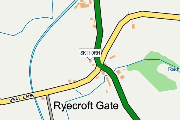
SK11 0RH lies on Beat Lane in Rushton Spencer, Macclesfield. SK11 0RH is located in the Horton electoral ward, within the local authority district of Staffordshire Moorlands and the English Parliamentary constituency of Staffordshire Moorlands. The Sub Integrated Care Board (ICB) Location is NHS Staffordshire and Stoke-on-Trent ICB - 05G and the police force is Staffordshire. This postcode has been in use since May 2008.


GetTheData
Source: OS OpenMap – Local (Ordnance Survey)
Source: OS VectorMap District (Ordnance Survey)
Licence: Open Government Licence (requires attribution)
| Easting | 393892 |
| Northing | 361683 |
| Latitude | 53.152246 |
| Longitude | -2.092788 |
GetTheData
Source: Open Postcode Geo
Licence: Open Government Licence
| Street | Beat Lane |
| Locality | Rushton Spencer |
| Town/City | Macclesfield |
| Country | England |
| Postcode District | SK11 |
➜ See where SK11 is on a map ➜ Where is Ryecroft Gate? | |
GetTheData
Source: Land Registry Price Paid Data
Licence: Open Government Licence
Elevation or altitude of SK11 0RH as distance above sea level:
| Metres | Feet | |
|---|---|---|
| Elevation | 170m | 558ft |
Elevation is measured from the approximate centre of the postcode, to the nearest point on an OS contour line from OS Terrain 50, which has contour spacing of ten vertical metres.
➜ How high above sea level am I? Find the elevation of your current position using your device's GPS.
GetTheData
Source: Open Postcode Elevation
Licence: Open Government Licence
| Ward | Horton |
| Constituency | Staffordshire Moorlands |
GetTheData
Source: ONS Postcode Database
Licence: Open Government Licence
| The Laurels (Macclesfield Rd) | Ryecroft Gate | 13m |
| The Laurels (Macclesfield Rd) | Ryecroft Gate | 29m |
| Station Lane (Macclesfield Rd) | Rushton Spencer | 755m |
| Station Lane (Macclesfield Rd) | Rushton Spencer | 940m |
GetTheData
Source: NaPTAN
Licence: Open Government Licence
| Percentage of properties with Next Generation Access | 100.0% |
| Percentage of properties with Superfast Broadband | 100.0% |
| Percentage of properties with Ultrafast Broadband | 0.0% |
| Percentage of properties with Full Fibre Broadband | 0.0% |
Superfast Broadband is between 30Mbps and 300Mbps
Ultrafast Broadband is > 300Mbps
| Percentage of properties unable to receive 2Mbps | 0.0% |
| Percentage of properties unable to receive 5Mbps | 0.0% |
| Percentage of properties unable to receive 10Mbps | 0.0% |
| Percentage of properties unable to receive 30Mbps | 0.0% |
GetTheData
Source: Ofcom
Licence: Ofcom Terms of Use (requires attribution)
GetTheData
Source: ONS Postcode Database
Licence: Open Government Licence

➜ Get more ratings from the Food Standards Agency
GetTheData
Source: Food Standards Agency
Licence: FSA terms & conditions
| Last Collection | |||
|---|---|---|---|
| Location | Mon-Fri | Sat | Distance |
| Rudyard Lake | 16:30 | 09:15 | 141m |
| Station Wall Rushton | 16:00 | 07:45 | 846m |
| Leek Road, Rushon | 16:15 | 07:00 | 890m |
GetTheData
Source: Dracos
Licence: Creative Commons Attribution-ShareAlike
The below table lists the International Territorial Level (ITL) codes (formerly Nomenclature of Territorial Units for Statistics (NUTS) codes) and Local Administrative Units (LAU) codes for SK11 0RH:
| ITL 1 Code | Name |
|---|---|
| TLG | West Midlands (England) |
| ITL 2 Code | Name |
| TLG2 | Shropshire and Staffordshire |
| ITL 3 Code | Name |
| TLG24 | Staffordshire CC |
| LAU 1 Code | Name |
| E07000198 | Staffordshire Moorlands |
GetTheData
Source: ONS Postcode Directory
Licence: Open Government Licence
The below table lists the Census Output Area (OA), Lower Layer Super Output Area (LSOA), and Middle Layer Super Output Area (MSOA) for SK11 0RH:
| Code | Name | |
|---|---|---|
| OA | E00151866 | |
| LSOA | E01029802 | Staffordshire Moorlands 002D |
| MSOA | E02006205 | Staffordshire Moorlands 002 |
GetTheData
Source: ONS Postcode Directory
Licence: Open Government Licence
| SK11 0RW | 107m | |
| SK11 0RP | Macclesfield Road | 113m |
| SK11 0RN | 670m | |
| SK11 0SF | Heaton | 723m |
| SK11 0SG | 737m | |
| SK11 0SQ | Sugar Street | 842m |
| SK11 0SD | Smithy Fold | 847m |
| SK11 0RB | 847m | |
| SK11 0QU | 894m | |
| SK11 0SE | 913m |
GetTheData
Source: Open Postcode Geo; Land Registry Price Paid Data
Licence: Open Government Licence