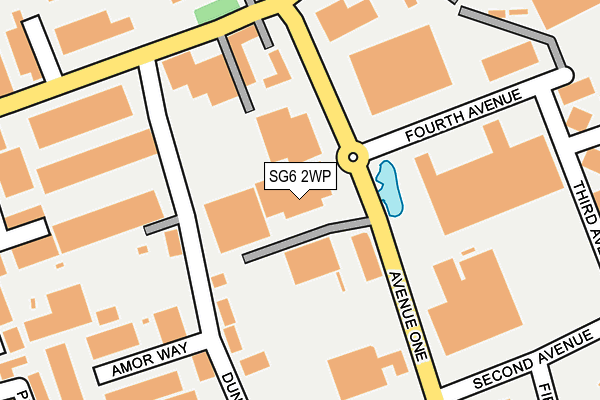
SG6 2WP lies on Avenue One in Letchworth Garden City. SG6 2WP is located in the Letchworth East electoral ward, within the local authority district of North Hertfordshire and the English Parliamentary constituency of North East Hertfordshire. The Sub Integrated Care Board (ICB) Location is NHS Hertfordshire and West Essex ICB - 06K and the police force is Hertfordshire. This postcode has been in use since December 2001.


GetTheData
Source: OS OpenMap – Local (Ordnance Survey)
Source: OS VectorMap District (Ordnance Survey)
Licence: Open Government Licence (requires attribution)
| Easting | 523008 |
| Northing | 233019 |
| Latitude | 51.982031 |
| Longitude | -0.210284 |
GetTheData
Source: Open Postcode Geo
Licence: Open Government Licence
| Street | Avenue One |
| Town/City | Letchworth Garden City |
| Country | England |
| Postcode District | SG6 |
➜ See where SG6 is on a map ➜ Where is Letchworth? | |
GetTheData
Source: Land Registry Price Paid Data
Licence: Open Government Licence
Elevation or altitude of SG6 2WP as distance above sea level:
| Metres | Feet | |
|---|---|---|
| Elevation | 80m | 262ft |
Elevation is measured from the approximate centre of the postcode, to the nearest point on an OS contour line from OS Terrain 50, which has contour spacing of ten vertical metres.
➜ How high above sea level am I? Find the elevation of your current position using your device's GPS.
GetTheData
Source: Open Postcode Elevation
Licence: Open Government Licence
| Ward | Letchworth East |
| Constituency | North East Hertfordshire |
GetTheData
Source: ONS Postcode Database
Licence: Open Government Licence
| Fourth Avenue (Avenue One) | Letchworth | 147m |
| Fourth Avenue (Avenue One) | Letchworth | 194m |
| Dunhams Lane (Works Road) | Letchworth | 195m |
| Dunhams Lane (Works Road) | Letchworth | 199m |
| Third Avenue (Fourth Avenue) | Letchworth | 206m |
| Letchworth Station | 1.3km |
| Baldock Station | 2km |
| Hitchin Station | 4.9km |
GetTheData
Source: NaPTAN
Licence: Open Government Licence
GetTheData
Source: ONS Postcode Database
Licence: Open Government Licence


➜ Get more ratings from the Food Standards Agency
GetTheData
Source: Food Standards Agency
Licence: FSA terms & conditions
| Last Collection | |||
|---|---|---|---|
| Location | Mon-Fri | Sat | Distance |
| Letchworth Delivery Office | 18:15 | 12:00 | 84m |
| Such Close | 285m | ||
| Birds Hill | 18:45 | 12:00 | 519m |
GetTheData
Source: Dracos
Licence: Creative Commons Attribution-ShareAlike
The below table lists the International Territorial Level (ITL) codes (formerly Nomenclature of Territorial Units for Statistics (NUTS) codes) and Local Administrative Units (LAU) codes for SG6 2WP:
| ITL 1 Code | Name |
|---|---|
| TLH | East |
| ITL 2 Code | Name |
| TLH2 | Bedfordshire and Hertfordshire |
| ITL 3 Code | Name |
| TLH23 | Hertfordshire CC |
| LAU 1 Code | Name |
| E07000099 | North Hertfordshire |
GetTheData
Source: ONS Postcode Directory
Licence: Open Government Licence
The below table lists the Census Output Area (OA), Lower Layer Super Output Area (LSOA), and Middle Layer Super Output Area (MSOA) for SG6 2WP:
| Code | Name | |
|---|---|---|
| OA | E00120008 | |
| LSOA | E01023633 | North Hertfordshire 006D |
| MSOA | E02004914 | North Hertfordshire 006 |
GetTheData
Source: ONS Postcode Directory
Licence: Open Government Licence
| SG6 1BE | Dunhams Lane | 122m |
| SG6 1UG | Amor Way | 207m |
| SG6 1LA | Woodside Industrial Park | 233m |
| SG6 1FX | Bowyer Drive | 268m |
| SG6 1FY | Phoenix Drive | 286m |
| SG6 1JT | Protea Way | 292m |
| SG6 1FW | Lowe Drive | 306m |
| SG6 2TS | Fifth Avenue | 339m |
| SG6 1FN | Wissen Drive | 362m |
| SG6 1FT | Wissen Drive | 394m |
GetTheData
Source: Open Postcode Geo; Land Registry Price Paid Data
Licence: Open Government Licence