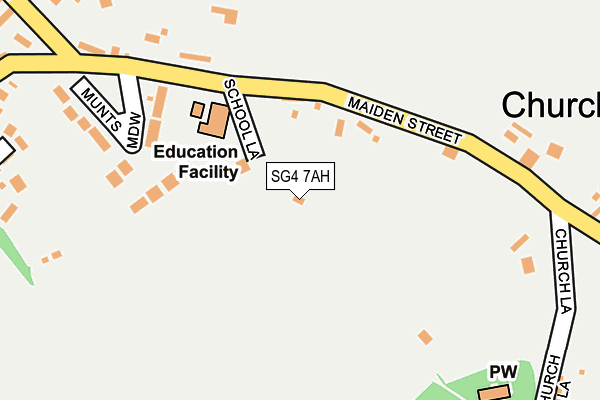
SG4 7AH lies on Church Lane in Weston, Hitchin. SG4 7AH is located in the Weston and Sandon electoral ward, within the local authority district of North Hertfordshire and the English Parliamentary constituency of North East Hertfordshire. The Sub Integrated Care Board (ICB) Location is NHS Hertfordshire and West Essex ICB - 06K and the police force is Hertfordshire. This postcode has been in use since January 1980.


GetTheData
Source: OS OpenMap – Local (Ordnance Survey)
Source: OS VectorMap District (Ordnance Survey)
Licence: Open Government Licence (requires attribution)
| Easting | 526396 |
| Northing | 230149 |
| Latitude | 51.955481 |
| Longitude | -0.162035 |
GetTheData
Source: Open Postcode Geo
Licence: Open Government Licence
| Street | Church Lane |
| Locality | Weston |
| Town/City | Hitchin |
| Country | England |
| Postcode District | SG4 |
➜ See where SG4 is on a map ➜ Where is Weston? | |
GetTheData
Source: Land Registry Price Paid Data
Licence: Open Government Licence
Elevation or altitude of SG4 7AH as distance above sea level:
| Metres | Feet | |
|---|---|---|
| Elevation | 130m | 427ft |
Elevation is measured from the approximate centre of the postcode, to the nearest point on an OS contour line from OS Terrain 50, which has contour spacing of ten vertical metres.
➜ How high above sea level am I? Find the elevation of your current position using your device's GPS.
GetTheData
Source: Open Postcode Elevation
Licence: Open Government Licence
| Ward | Weston And Sandon |
| Constituency | North East Hertfordshire |
GetTheData
Source: ONS Postcode Database
Licence: Open Government Licence
2022 2 FEB £1,080,000 |
2015 23 DEC £735,000 |
2011 1 JUL £575,000 |
2007 28 MAR £530,000 |
GetTheData
Source: HM Land Registry Price Paid Data
Licence: Contains HM Land Registry data © Crown copyright and database right 2025. This data is licensed under the Open Government Licence v3.0.
| Red Lion Ph (Damask Green Road) | Weston | 544m |
| Red Lion Ph (Post Office Row) | Weston | 576m |
| Rising Sun Ph (Dane End Lane) | Hall's Green | 1,755m |
| Rising Sun Ph (Dane End Lane) | Hall's Green | 1,756m |
| Baldock Station | 4.5km |
| Letchworth Station | 5.4km |
GetTheData
Source: NaPTAN
Licence: Open Government Licence
| Percentage of properties with Next Generation Access | 100.0% |
| Percentage of properties with Superfast Broadband | 66.7% |
| Percentage of properties with Ultrafast Broadband | 0.0% |
| Percentage of properties with Full Fibre Broadband | 0.0% |
Superfast Broadband is between 30Mbps and 300Mbps
Ultrafast Broadband is > 300Mbps
| Percentage of properties unable to receive 2Mbps | 0.0% |
| Percentage of properties unable to receive 5Mbps | 0.0% |
| Percentage of properties unable to receive 10Mbps | 0.0% |
| Percentage of properties unable to receive 30Mbps | 33.3% |
GetTheData
Source: Ofcom
Licence: Ofcom Terms of Use (requires attribution)
GetTheData
Source: ONS Postcode Database
Licence: Open Government Licence


➜ Get more ratings from the Food Standards Agency
GetTheData
Source: Food Standards Agency
Licence: FSA terms & conditions
| Last Collection | |||
|---|---|---|---|
| Location | Mon-Fri | Sat | Distance |
| Munts Meadow | 16:00 | 08:15 | 222m |
| Weston | 16:15 | 09:15 | 582m |
| Lannock | 16:15 | 09:15 | 1,743m |
GetTheData
Source: Dracos
Licence: Creative Commons Attribution-ShareAlike
The below table lists the International Territorial Level (ITL) codes (formerly Nomenclature of Territorial Units for Statistics (NUTS) codes) and Local Administrative Units (LAU) codes for SG4 7AH:
| ITL 1 Code | Name |
|---|---|
| TLH | East |
| ITL 2 Code | Name |
| TLH2 | Bedfordshire and Hertfordshire |
| ITL 3 Code | Name |
| TLH23 | Hertfordshire CC |
| LAU 1 Code | Name |
| E07000099 | North Hertfordshire |
GetTheData
Source: ONS Postcode Directory
Licence: Open Government Licence
The below table lists the Census Output Area (OA), Lower Layer Super Output Area (LSOA), and Middle Layer Super Output Area (MSOA) for SG4 7AH:
| Code | Name | |
|---|---|---|
| OA | E00120177 | |
| LSOA | E01023663 | North Hertfordshire 005G |
| MSOA | E02004913 | North Hertfordshire 005 |
GetTheData
Source: ONS Postcode Directory
Licence: Open Government Licence
| SG4 7BG | Maiden Street | 96m |
| SG4 7AE | Munts Meadow | 179m |
| SG4 7AG | Maiden Street | 221m |
| SG4 7AQ | Forge End | 310m |
| SG4 7AD | Butts Green | 316m |
| SG4 7DJ | Church Lane | 319m |
| SG4 7AB | Mill Lane | 349m |
| SG4 7AJ | Mill Lane | 367m |
| SG4 7AA | Maiden Street | 379m |
| SG4 7DL | 446m |
GetTheData
Source: Open Postcode Geo; Land Registry Price Paid Data
Licence: Open Government Licence