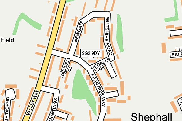
SG2 9DY lies on Peartree Way in Stevenage. SG2 9DY is located in the Shephall electoral ward, within the local authority district of Stevenage and the English Parliamentary constituency of Stevenage. The Sub Integrated Care Board (ICB) Location is NHS Hertfordshire and West Essex ICB - 06K and the police force is Hertfordshire. This postcode has been in use since January 1980.


GetTheData
Source: OS OpenMap – Local (Ordnance Survey)
Source: OS VectorMap District (Ordnance Survey)
Licence: Open Government Licence (requires attribution)
| Easting | 525364 |
| Northing | 223426 |
| Latitude | 51.895292 |
| Longitude | -0.179517 |
GetTheData
Source: Open Postcode Geo
Licence: Open Government Licence
| Street | Peartree Way |
| Town/City | Stevenage |
| Country | England |
| Postcode District | SG2 |
➜ See where SG2 is on a map ➜ Where is Stevenage? | |
GetTheData
Source: Land Registry Price Paid Data
Licence: Open Government Licence
Elevation or altitude of SG2 9DY as distance above sea level:
| Metres | Feet | |
|---|---|---|
| Elevation | 110m | 361ft |
Elevation is measured from the approximate centre of the postcode, to the nearest point on an OS contour line from OS Terrain 50, which has contour spacing of ten vertical metres.
➜ How high above sea level am I? Find the elevation of your current position using your device's GPS.
GetTheData
Source: Open Postcode Elevation
Licence: Open Government Licence
| Ward | Shephall |
| Constituency | Stevenage |
GetTheData
Source: ONS Postcode Database
Licence: Open Government Licence
| Peartree Way (Valley Way) | Shephall | 142m |
| Peartree Way (Valley Way) | Shephall | 148m |
| School Close (Paddocks Close) | Shephall | 337m |
| Paddocks Close (The Paddocks) | Shephall | 364m |
| Peartree Centre (Valley Way) | Shephall | 381m |
| Stevenage Station | 2km |
| Knebworth Station | 3.2km |
| Watton-at-Stone Station | 6km |
GetTheData
Source: NaPTAN
Licence: Open Government Licence
| Percentage of properties with Next Generation Access | 100.0% |
| Percentage of properties with Superfast Broadband | 100.0% |
| Percentage of properties with Ultrafast Broadband | 100.0% |
| Percentage of properties with Full Fibre Broadband | 0.0% |
Superfast Broadband is between 30Mbps and 300Mbps
Ultrafast Broadband is > 300Mbps
| Percentage of properties unable to receive 2Mbps | 0.0% |
| Percentage of properties unable to receive 5Mbps | 0.0% |
| Percentage of properties unable to receive 10Mbps | 0.0% |
| Percentage of properties unable to receive 30Mbps | 0.0% |
GetTheData
Source: Ofcom
Licence: Ofcom Terms of Use (requires attribution)
GetTheData
Source: ONS Postcode Database
Licence: Open Government Licence


➜ Get more ratings from the Food Standards Agency
GetTheData
Source: Food Standards Agency
Licence: FSA terms & conditions
| Last Collection | |||
|---|---|---|---|
| Location | Mon-Fri | Sat | Distance |
| Peartree Way | 18:15 | 12:00 | 38m |
| The Paddocks | 17:30 | 12:30 | 329m |
| Leaves Spring Post Office | 18:45 | 12:00 | 400m |
GetTheData
Source: Dracos
Licence: Creative Commons Attribution-ShareAlike
The below table lists the International Territorial Level (ITL) codes (formerly Nomenclature of Territorial Units for Statistics (NUTS) codes) and Local Administrative Units (LAU) codes for SG2 9DY:
| ITL 1 Code | Name |
|---|---|
| TLH | East |
| ITL 2 Code | Name |
| TLH2 | Bedfordshire and Hertfordshire |
| ITL 3 Code | Name |
| TLH23 | Hertfordshire CC |
| LAU 1 Code | Name |
| E07000243 | Stevenage |
GetTheData
Source: ONS Postcode Directory
Licence: Open Government Licence
The below table lists the Census Output Area (OA), Lower Layer Super Output Area (LSOA), and Middle Layer Super Output Area (MSOA) for SG2 9DY:
| Code | Name | |
|---|---|---|
| OA | E00120813 | |
| LSOA | E01023791 | Stevenage 010A |
| MSOA | E02004953 | Stevenage 010 |
GetTheData
Source: ONS Postcode Directory
Licence: Open Government Licence
| SG2 9DR | Hadwell Close | 81m |
| SG2 9DS | Newgate | 85m |
| SG2 9DQ | Medalls Link | 88m |
| SG2 9DU | Wiltshire Road | 97m |
| SG2 9DX | Medalls Path | 105m |
| SG2 9DZ | Peartree Way | 106m |
| SG2 9DP | Peartree Way | 113m |
| SG2 9BX | Valley Way | 134m |
| SG2 9BU | Valley Way | 156m |
| SG2 9DT | Newgate | 178m |
GetTheData
Source: Open Postcode Geo; Land Registry Price Paid Data
Licence: Open Government Licence