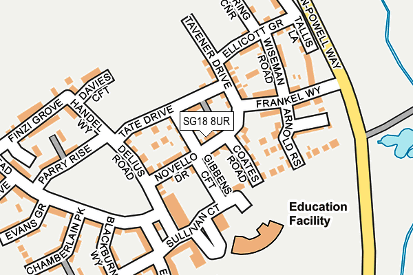
SG18 8UR is located in the Biggleswade East electoral ward, within the unitary authority of Central Bedfordshire and the English Parliamentary constituency of North East Bedfordshire. The Sub Integrated Care Board (ICB) Location is NHS Bedfordshire, Luton and Milton Keynes ICB - M1J4Y and the police force is Bedfordshire. This postcode has been in use since July 2016.


GetTheData
Source: OS OpenMap – Local (Ordnance Survey)
Source: OS VectorMap District (Ordnance Survey)
Licence: Open Government Licence (requires attribution)
| Easting | 520598 |
| Northing | 245374 |
| Latitude | 52.093589 |
| Longitude | -0.241007 |
GetTheData
Source: Open Postcode Geo
Licence: Open Government Licence
| Country | England |
| Postcode District | SG18 |
➜ See where SG18 is on a map ➜ Where is Biggleswade? | |
GetTheData
Source: Land Registry Price Paid Data
Licence: Open Government Licence
Elevation or altitude of SG18 8UR as distance above sea level:
| Metres | Feet | |
|---|---|---|
| Elevation | 30m | 98ft |
Elevation is measured from the approximate centre of the postcode, to the nearest point on an OS contour line from OS Terrain 50, which has contour spacing of ten vertical metres.
➜ How high above sea level am I? Find the elevation of your current position using your device's GPS.
GetTheData
Source: Open Postcode Elevation
Licence: Open Government Licence
| Ward | Biggleswade East |
| Constituency | North East Bedfordshire |
GetTheData
Source: ONS Postcode Database
Licence: Open Government Licence
2024 6 MAR £425,000 |
2022 27 MAY £540,000 |
2021 13 AUG £525,000 |
2020 22 JUL £420,000 |
2017 30 NOV £420,000 |
27, NOVELLO DRIVE, BIGGLESWADE, SG18 8UR 2017 24 NOV £470,000 |
2017 10 NOV £470,000 |
2017 7 JUL £462,000 |
30, NOVELLO DRIVE, BIGGLESWADE, SG18 8UR 2017 30 JUN £352,500 |
18, NOVELLO DRIVE, BIGGLESWADE, SG18 8UR 2017 16 MAY £450,000 |
GetTheData
Source: HM Land Registry Price Paid Data
Licence: Contains HM Land Registry data © Crown copyright and database right 2025. This data is licensed under the Open Government Licence v3.0.
| Apollo Gardens (Venus Avenue) | Kings Reach | 503m |
| Glebe Road (Stratton Way) | Stratton | 649m |
| Hitchmead School (Stratton Way) | Stratton | 657m |
| Hitchmead School (Stratton Way) | Stratton | 670m |
| Post Office (Stratton Way) | Biggleswade | 694m |
| Biggleswade Station | 1.7km |
| Sandy Station | 4.4km |
GetTheData
Source: NaPTAN
Licence: Open Government Licence
| Percentage of properties with Next Generation Access | 100.0% |
| Percentage of properties with Superfast Broadband | 100.0% |
| Percentage of properties with Ultrafast Broadband | 100.0% |
| Percentage of properties with Full Fibre Broadband | 100.0% |
Superfast Broadband is between 30Mbps and 300Mbps
Ultrafast Broadband is > 300Mbps
| Percentage of properties unable to receive 2Mbps | 0.0% |
| Percentage of properties unable to receive 5Mbps | 0.0% |
| Percentage of properties unable to receive 10Mbps | 0.0% |
| Percentage of properties unable to receive 30Mbps | 0.0% |
GetTheData
Source: Ofcom
Licence: Ofcom Terms of Use (requires attribution)
GetTheData
Source: ONS Postcode Database
Licence: Open Government Licence


➜ Get more ratings from the Food Standards Agency
GetTheData
Source: Food Standards Agency
Licence: FSA terms & conditions
| Last Collection | |||
|---|---|---|---|
| Location | Mon-Fri | Sat | Distance |
| Stratton Way | 17:15 | 11:00 | 678m |
| Laburnham Road | 17:15 | 11:00 | 780m |
| Drove Road | 17:15 | 11:00 | 1,004m |
GetTheData
Source: Dracos
Licence: Creative Commons Attribution-ShareAlike
The below table lists the International Territorial Level (ITL) codes (formerly Nomenclature of Territorial Units for Statistics (NUTS) codes) and Local Administrative Units (LAU) codes for SG18 8UR:
| ITL 1 Code | Name |
|---|---|
| TLH | East |
| ITL 2 Code | Name |
| TLH2 | Bedfordshire and Hertfordshire |
| ITL 3 Code | Name |
| TLH25 | Central Bedfordshire |
| LAU 1 Code | Name |
| E06000056 | Central Bedfordshire |
GetTheData
Source: ONS Postcode Directory
Licence: Open Government Licence
The below table lists the Census Output Area (OA), Lower Layer Super Output Area (LSOA), and Middle Layer Super Output Area (MSOA) for SG18 8UR:
| Code | Name | |
|---|---|---|
| OA | E00087832 | |
| LSOA | E01017390 | Central Bedfordshire 006D |
| MSOA | E02003604 | Central Bedfordshire 006 |
GetTheData
Source: ONS Postcode Directory
Licence: Open Government Licence
| SG18 8UF | Arnold Rise | 111m |
| SG18 8GY | Frankel Way | 119m |
| SG18 8LN | Wiseman Road | 136m |
| SG18 8UG | Holbrook Grove | 160m |
| SG18 8HT | Ellicott Grove | 167m |
| SG18 8GZ | Tavener Drive | 170m |
| SG18 8RE | Sullivan Court | 174m |
| SG18 8JY | Tallis Lane | 188m |
| SG18 8GU | Blackburn Way | 212m |
| SG18 8GX | Somerville Croft | 227m |
GetTheData
Source: Open Postcode Geo; Land Registry Price Paid Data
Licence: Open Government Licence