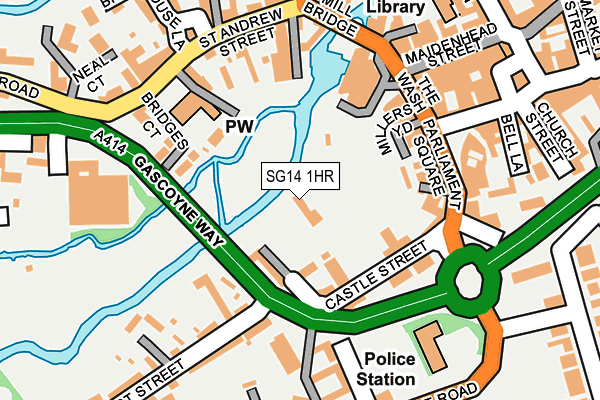
SG14 1HR is located in the Hertford Castle electoral ward, within the local authority district of East Hertfordshire and the English Parliamentary constituency of Hertford and Stortford. The Sub Integrated Care Board (ICB) Location is NHS Hertfordshire and West Essex ICB - 06K and the police force is Hertfordshire. This postcode has been in use since July 2005.


GetTheData
Source: OS OpenMap – Local (Ordnance Survey)
Source: OS VectorMap District (Ordnance Survey)
Licence: Open Government Licence (requires attribution)
| Easting | 532455 |
| Northing | 212472 |
| Latitude | 51.795222 |
| Longitude | -0.080717 |
GetTheData
Source: Open Postcode Geo
Licence: Open Government Licence
| Country | England |
| Postcode District | SG14 |
➜ See where SG14 is on a map ➜ Where is Hertford? | |
GetTheData
Source: Land Registry Price Paid Data
Licence: Open Government Licence
Elevation or altitude of SG14 1HR as distance above sea level:
| Metres | Feet | |
|---|---|---|
| Elevation | 40m | 131ft |
Elevation is measured from the approximate centre of the postcode, to the nearest point on an OS contour line from OS Terrain 50, which has contour spacing of ten vertical metres.
➜ How high above sea level am I? Find the elevation of your current position using your device's GPS.
GetTheData
Source: Open Postcode Elevation
Licence: Open Government Licence
| Ward | Hertford Castle |
| Constituency | Hertford And Stortford |
GetTheData
Source: ONS Postcode Database
Licence: Open Government Licence
| Theatre (The Wash) | Hertford | 174m |
| Theatre (Mill Bridge) | Hertford | 177m |
| St Andrews Church (St Andrew Street) | Hertford | 183m |
| St Andrews Church (St Andrew Street) | Hertford | 192m |
| Richard Hale School (Hale Road) | Hertford | 244m |
| Hertford East Station | 0.7km |
| Hertford North Station | 0.9km |
| Ware Station | 3.9km |
GetTheData
Source: NaPTAN
Licence: Open Government Licence
GetTheData
Source: ONS Postcode Database
Licence: Open Government Licence


➜ Get more ratings from the Food Standards Agency
GetTheData
Source: Food Standards Agency
Licence: FSA terms & conditions
| Last Collection | |||
|---|---|---|---|
| Location | Mon-Fri | Sat | Distance |
| Old Cross | 18:30 | 12:30 | 209m |
| Railway Street | 18:30 | 12:30 | 318m |
| Fore Street | 18:30 | 12:30 | 338m |
GetTheData
Source: Dracos
Licence: Creative Commons Attribution-ShareAlike
The below table lists the International Territorial Level (ITL) codes (formerly Nomenclature of Territorial Units for Statistics (NUTS) codes) and Local Administrative Units (LAU) codes for SG14 1HR:
| ITL 1 Code | Name |
|---|---|
| TLH | East |
| ITL 2 Code | Name |
| TLH2 | Bedfordshire and Hertfordshire |
| ITL 3 Code | Name |
| TLH23 | Hertfordshire CC |
| LAU 1 Code | Name |
| E07000242 | East Hertfordshire |
GetTheData
Source: ONS Postcode Directory
Licence: Open Government Licence
The below table lists the Census Output Area (OA), Lower Layer Super Output Area (LSOA), and Middle Layer Super Output Area (MSOA) for SG14 1HR:
| Code | Name | |
|---|---|---|
| OA | E00119253 | |
| LSOA | E01023478 | East Hertfordshire 017D |
| MSOA | E02004894 | East Hertfordshire 017 |
GetTheData
Source: ONS Postcode Directory
Licence: Open Government Licence
| SG14 1HD | Castle Gate | 92m |
| SG13 8EU | Westall Mews | 110m |
| SG14 1HH | Castle Street | 116m |
| SG14 1HQ | Bridges Court | 118m |
| SG13 8ES | Malting Mews | 128m |
| SG14 1HU | Millers Court | 133m |
| SG14 1EZ | Parliament Square | 136m |
| SG14 1HG | St Andrew Mews | 138m |
| SG14 1EF | Parliament Square | 138m |
| SG14 1HZ | St Andrew Street | 139m |
GetTheData
Source: Open Postcode Geo; Land Registry Price Paid Data
Licence: Open Government Licence