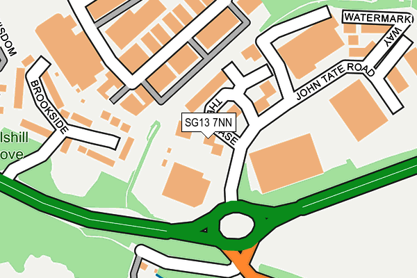
SG13 7NN lies on The Chase in Hertford. SG13 7NN is located in the Hertford Kingsmead electoral ward, within the local authority district of East Hertfordshire and the English Parliamentary constituency of Hertford and Stortford. The Sub Integrated Care Board (ICB) Location is NHS Hertfordshire and West Essex ICB - 06K and the police force is Hertfordshire. This postcode has been in use since February 1990.


GetTheData
Source: OS OpenMap – Local (Ordnance Survey)
Source: OS VectorMap District (Ordnance Survey)
Licence: Open Government Licence (requires attribution)
| Easting | 533744 |
| Northing | 212491 |
| Latitude | 51.795092 |
| Longitude | -0.062002 |
GetTheData
Source: Open Postcode Geo
Licence: Open Government Licence
| Street | The Chase |
| Town/City | Hertford |
| Country | England |
| Postcode District | SG13 |
➜ See where SG13 is on a map ➜ Where is Hertford? | |
GetTheData
Source: Land Registry Price Paid Data
Licence: Open Government Licence
Elevation or altitude of SG13 7NN as distance above sea level:
| Metres | Feet | |
|---|---|---|
| Elevation | 60m | 197ft |
Elevation is measured from the approximate centre of the postcode, to the nearest point on an OS contour line from OS Terrain 50, which has contour spacing of ten vertical metres.
➜ How high above sea level am I? Find the elevation of your current position using your device's GPS.
GetTheData
Source: Open Postcode Elevation
Licence: Open Government Licence
| Ward | Hertford Kingsmead |
| Constituency | Hertford And Stortford |
GetTheData
Source: ONS Postcode Database
Licence: Open Government Licence
| Balls Park Lodge (London Road) | Hertford | 263m |
| Balls Park Lodge (London Road) | Hertford | 276m |
| Raynham Street (Ware Road) | Hertford | 465m |
| Raynham Street (Ware Road) | Hertford | 484m |
| Caxton Hill (Ware Road) | Hertford | 518m |
| Hertford East Station | 0.9km |
| Hertford North Station | 2.1km |
| Ware Station | 2.7km |
GetTheData
Source: NaPTAN
Licence: Open Government Licence
Estimated total energy consumption in SG13 7NN by fuel type, 2015.
| Consumption (kWh) | 99,154 |
|---|---|
| Meter count | 8 |
| Mean (kWh/meter) | 12,394 |
| Median (kWh/meter) | 1,006 |
GetTheData
Source: Postcode level gas estimates: 2015 (experimental)
Source: Postcode level electricity estimates: 2015 (experimental)
Licence: Open Government Licence
GetTheData
Source: ONS Postcode Database
Licence: Open Government Licence

➜ Get more ratings from the Food Standards Agency
GetTheData
Source: Food Standards Agency
Licence: FSA terms & conditions
| Last Collection | |||
|---|---|---|---|
| Location | Mon-Fri | Sat | Distance |
| Foxholes Business Park | 18:30 | 71m | |
| Foxholes Avenue | 17:15 | 12:00 | 345m |
| Ware Road | 17:30 | 12:00 | 466m |
GetTheData
Source: Dracos
Licence: Creative Commons Attribution-ShareAlike
The below table lists the International Territorial Level (ITL) codes (formerly Nomenclature of Territorial Units for Statistics (NUTS) codes) and Local Administrative Units (LAU) codes for SG13 7NN:
| ITL 1 Code | Name |
|---|---|
| TLH | East |
| ITL 2 Code | Name |
| TLH2 | Bedfordshire and Hertfordshire |
| ITL 3 Code | Name |
| TLH23 | Hertfordshire CC |
| LAU 1 Code | Name |
| E07000242 | East Hertfordshire |
GetTheData
Source: ONS Postcode Directory
Licence: Open Government Licence
The below table lists the Census Output Area (OA), Lower Layer Super Output Area (LSOA), and Middle Layer Super Output Area (MSOA) for SG13 7NN:
| Code | Name | |
|---|---|---|
| OA | E00119272 | |
| LSOA | E01023483 | East Hertfordshire 016B |
| MSOA | E02004893 | East Hertfordshire 016 |
GetTheData
Source: ONS Postcode Directory
Licence: Open Government Licence
| SG13 7LL | Brookside | 169m |
| SG13 7TZ | Foxholes Business Park | 239m |
| SG13 7NW | Harforde Court | 267m |
| SG13 7JS | Braziers Field | 277m |
| SG13 7JF | Woodlands Road | 289m |
| SG13 7JH | Foxholes Avenue | 296m |
| SG13 7NR | Deer Close | 298m |
| SG13 7LJ | Brookside | 312m |
| SG13 7HZ | Copperwood | 329m |
| SG13 7NL | Fallow Rise | 345m |
GetTheData
Source: Open Postcode Geo; Land Registry Price Paid Data
Licence: Open Government Licence