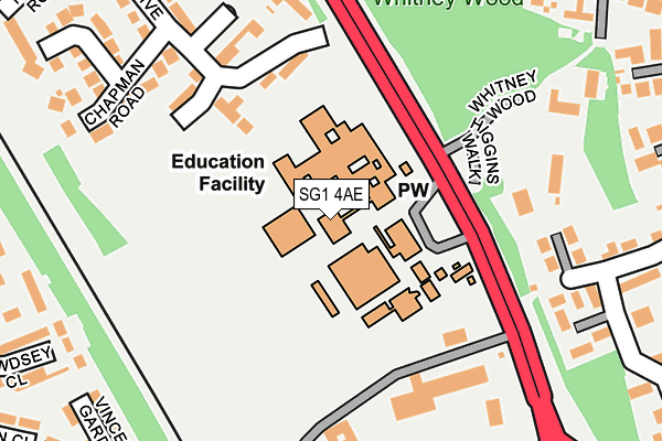
SG1 4AE lies on Whitney Wood in Stevenage. SG1 4AE is located in the Woodfield electoral ward, within the local authority district of Stevenage and the English Parliamentary constituency of Stevenage. The Sub Integrated Care Board (ICB) Location is NHS Hertfordshire and West Essex ICB - 06K and the police force is Hertfordshire. This postcode has been in use since January 1980.


GetTheData
Source: OS OpenMap – Local (Ordnance Survey)
Source: OS VectorMap District (Ordnance Survey)
Licence: Open Government Licence (requires attribution)
| Easting | 522859 |
| Northing | 226126 |
| Latitude | 51.920112 |
| Longitude | -0.214941 |
GetTheData
Source: Open Postcode Geo
Licence: Open Government Licence
| Street | Whitney Wood |
| Town/City | Stevenage |
| Country | England |
| Postcode District | SG1 |
➜ See where SG1 is on a map ➜ Where is Stevenage? | |
GetTheData
Source: Land Registry Price Paid Data
Licence: Open Government Licence
Elevation or altitude of SG1 4AE as distance above sea level:
| Metres | Feet | |
|---|---|---|
| Elevation | 100m | 328ft |
Elevation is measured from the approximate centre of the postcode, to the nearest point on an OS contour line from OS Terrain 50, which has contour spacing of ten vertical metres.
➜ How high above sea level am I? Find the elevation of your current position using your device's GPS.
GetTheData
Source: Open Postcode Elevation
Licence: Open Government Licence
| Ward | Woodfield |
| Constituency | Stevenage |
GetTheData
Source: ONS Postcode Database
Licence: Open Government Licence
| John Henry Newman School Grounds (Hitchin Road) | Corey's Mill | 81m |
| John Henry Newman School (Hitchin Road) | Corey's Mill | 160m |
| John Henry Newman School (Hitchin Road) | Corey's Mill | 236m |
| Southsea Road (Fishers Green Road) | Fishers Green | 333m |
| Lister Hospital | Corey's Mill | 364m |
| Stevenage Station | 2.1km |
| Hitchin Station | 5km |
GetTheData
Source: NaPTAN
Licence: Open Government Licence
GetTheData
Source: ONS Postcode Database
Licence: Open Government Licence


➜ Get more ratings from the Food Standards Agency
GetTheData
Source: Food Standards Agency
Licence: FSA terms & conditions
| Last Collection | |||
|---|---|---|---|
| Location | Mon-Fri | Sat | Distance |
| Ingleside Drive | 18:45 | 12:00 | 285m |
| Fishers Green | 17:30 | 12:15 | 407m |
| Baldock Road | 18:45 | 12:00 | 446m |
GetTheData
Source: Dracos
Licence: Creative Commons Attribution-ShareAlike
The below table lists the International Territorial Level (ITL) codes (formerly Nomenclature of Territorial Units for Statistics (NUTS) codes) and Local Administrative Units (LAU) codes for SG1 4AE:
| ITL 1 Code | Name |
|---|---|
| TLH | East |
| ITL 2 Code | Name |
| TLH2 | Bedfordshire and Hertfordshire |
| ITL 3 Code | Name |
| TLH23 | Hertfordshire CC |
| LAU 1 Code | Name |
| E07000243 | Stevenage |
GetTheData
Source: ONS Postcode Directory
Licence: Open Government Licence
The below table lists the Census Output Area (OA), Lower Layer Super Output Area (LSOA), and Middle Layer Super Output Area (MSOA) for SG1 4AE:
| Code | Name | |
|---|---|---|
| OA | E00120856 | |
| LSOA | E01023800 | Stevenage 002E |
| MSOA | E02004945 | Stevenage 002 |
GetTheData
Source: ONS Postcode Directory
Licence: Open Government Licence
| SG1 4RG | Ingleside Drive | 142m |
| SG1 4RQ | Ingleside Drive | 145m |
| SG1 4RF | Ingleside Drive | 175m |
| SG1 4RE | Ingleside Drive | 187m |
| SG1 4RD | Ingleside Drive | 210m |
| SG1 4FE | Whitney Wood | 233m |
| SG1 4RL | Ansell Court | 249m |
| SG1 4BH | Whitney Drive | 249m |
| SG1 4RJ | Chapman Road | 266m |
| SG1 4FJ | The Mews | 266m |
GetTheData
Source: Open Postcode Geo; Land Registry Price Paid Data
Licence: Open Government Licence