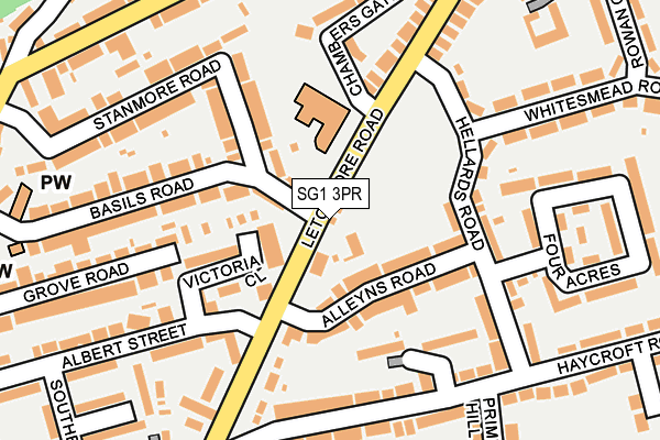
SG1 3PR lies on Letchmore Road in Stevenage. SG1 3PR is located in the Old Town electoral ward, within the local authority district of Stevenage and the English Parliamentary constituency of Stevenage. The Sub Integrated Care Board (ICB) Location is NHS Hertfordshire and West Essex ICB - 06K and the police force is Hertfordshire. This postcode has been in use since January 1980.


GetTheData
Source: OS OpenMap – Local (Ordnance Survey)
Source: OS VectorMap District (Ordnance Survey)
Licence: Open Government Licence (requires attribution)
| Easting | 523746 |
| Northing | 225250 |
| Latitude | 51.912044 |
| Longitude | -0.202364 |
GetTheData
Source: Open Postcode Geo
Licence: Open Government Licence
| Street | Letchmore Road |
| Town/City | Stevenage |
| Country | England |
| Postcode District | SG1 |
➜ See where SG1 is on a map ➜ Where is Stevenage? | |
GetTheData
Source: Land Registry Price Paid Data
Licence: Open Government Licence
Elevation or altitude of SG1 3PR as distance above sea level:
| Metres | Feet | |
|---|---|---|
| Elevation | 100m | 328ft |
Elevation is measured from the approximate centre of the postcode, to the nearest point on an OS contour line from OS Terrain 50, which has contour spacing of ten vertical metres.
➜ How high above sea level am I? Find the elevation of your current position using your device's GPS.
GetTheData
Source: Open Postcode Elevation
Licence: Open Government Licence
| Ward | Old Town |
| Constituency | Stevenage |
GetTheData
Source: ONS Postcode Database
Licence: Open Government Licence
34, LETCHMORE ROAD, STEVENAGE, SG1 3PR 2010 31 MAR £250,000 |
36, LETCHMORE ROAD, STEVENAGE, SG1 3PR 2007 16 NOV £266,000 |
36, LETCHMORE ROAD, STEVENAGE, SG1 3PR 2002 31 MAY £166,000 |
GetTheData
Source: HM Land Registry Price Paid Data
Licence: Contains HM Land Registry data © Crown copyright and database right 2025. This data is licensed under the Open Government Licence v3.0.
| The Dun Cow Ph (Letchmore Road) | Stevenage Old Town | 47m |
| The Dun Cow Ph (Letchmore Road) | Stevenage Old Town | 51m |
| Ingleheim Court (Haycroft Road) | Pin Green | 193m |
| Royal Oak Ph (Walkern Road) | Stevenage Old Town | 256m |
| Walkern Road (Letchmore Road) | Stevenage Old Town | 261m |
| Stevenage Station | 1.2km |
| Knebworth Station | 5.1km |
| Hitchin Station | 6.2km |
GetTheData
Source: NaPTAN
Licence: Open Government Licence
| Percentage of properties with Next Generation Access | 100.0% |
| Percentage of properties with Superfast Broadband | 100.0% |
| Percentage of properties with Ultrafast Broadband | 100.0% |
| Percentage of properties with Full Fibre Broadband | 0.0% |
Superfast Broadband is between 30Mbps and 300Mbps
Ultrafast Broadband is > 300Mbps
| Percentage of properties unable to receive 2Mbps | 0.0% |
| Percentage of properties unable to receive 5Mbps | 0.0% |
| Percentage of properties unable to receive 10Mbps | 0.0% |
| Percentage of properties unable to receive 30Mbps | 0.0% |
GetTheData
Source: Ofcom
Licence: Ofcom Terms of Use (requires attribution)
GetTheData
Source: ONS Postcode Database
Licence: Open Government Licence


➜ Get more ratings from the Food Standards Agency
GetTheData
Source: Food Standards Agency
Licence: FSA terms & conditions
| Last Collection | |||
|---|---|---|---|
| Location | Mon-Fri | Sat | Distance |
| Alleyns Road | 17:30 | 12:15 | 85m |
| Whitesmead Road | 17:30 | 12:30 | 369m |
| High Street | 19:00 | 12:15 | 395m |
GetTheData
Source: Dracos
Licence: Creative Commons Attribution-ShareAlike
The below table lists the International Territorial Level (ITL) codes (formerly Nomenclature of Territorial Units for Statistics (NUTS) codes) and Local Administrative Units (LAU) codes for SG1 3PR:
| ITL 1 Code | Name |
|---|---|
| TLH | East |
| ITL 2 Code | Name |
| TLH2 | Bedfordshire and Hertfordshire |
| ITL 3 Code | Name |
| TLH23 | Hertfordshire CC |
| LAU 1 Code | Name |
| E07000243 | Stevenage |
GetTheData
Source: ONS Postcode Directory
Licence: Open Government Licence
The below table lists the Census Output Area (OA), Lower Layer Super Output Area (LSOA), and Middle Layer Super Output Area (MSOA) for SG1 3PR:
| Code | Name | |
|---|---|---|
| OA | E00120738 | |
| LSOA | E01023775 | Stevenage 006A |
| MSOA | E02004949 | Stevenage 006 |
GetTheData
Source: ONS Postcode Directory
Licence: Open Government Licence
| SG1 3PU | Basils Road | 61m |
| SG1 3PG | Alleyns Road | 72m |
| SG1 3PP | Alleyns Road | 88m |
| SG1 3PZ | Basils Road | 91m |
| SG1 3PB | Victoria Close | 91m |
| SG1 3PH | Hellards Road | 132m |
| SG1 3QE | Stanmore Road | 138m |
| SG1 3JL | Haycroft Road | 168m |
| SG1 3JS | Haycroft Road | 181m |
| SG1 3JH | Letchmore Road | 190m |
GetTheData
Source: Open Postcode Geo; Land Registry Price Paid Data
Licence: Open Government Licence