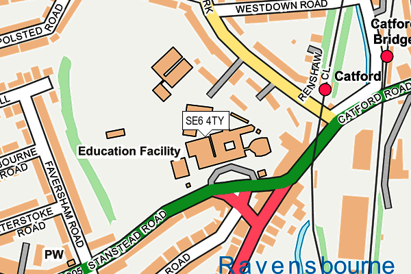
SE6 4TY is located in the Rushey Green electoral ward, within the London borough of Lewisham and the English Parliamentary constituency of Lewisham East. The Sub Integrated Care Board (ICB) Location is NHS South East London ICB - 72Q and the police force is Metropolitan Police. This postcode has been in use since January 1980.


GetTheData
Source: OS OpenMap – Local (Ordnance Survey)
Source: OS VectorMap District (Ordnance Survey)
Licence: Open Government Licence (requires attribution)
| Easting | 537093 |
| Northing | 173490 |
| Latitude | 51.443816 |
| Longitude | -0.028745 |
GetTheData
Source: Open Postcode Geo
Licence: Open Government Licence
| Country | England |
| Postcode District | SE6 |
➜ See where SE6 is on a map ➜ Where is Catford? | |
GetTheData
Source: Land Registry Price Paid Data
Licence: Open Government Licence
Elevation or altitude of SE6 4TY as distance above sea level:
| Metres | Feet | |
|---|---|---|
| Elevation | 30m | 98ft |
Elevation is measured from the approximate centre of the postcode, to the nearest point on an OS contour line from OS Terrain 50, which has contour spacing of ten vertical metres.
➜ How high above sea level am I? Find the elevation of your current position using your device's GPS.
GetTheData
Source: Open Postcode Elevation
Licence: Open Government Licence
| Ward | Rushey Green |
| Constituency | Lewisham East |
GetTheData
Source: ONS Postcode Database
Licence: Open Government Licence
| Stanstead Rdst Dunstans (Stanstead Road) | Catford | 96m |
| Hilary House | Catford | 126m |
| St Dunstans College (Stanstead Road) | Catford | 151m |
| Sussex Mews | Catford | 167m |
| St Dunstans College (Stanstead Road) | Catford | 205m |
| Catford Station | 0.2km |
| Catford Bridge Station | 0.3km |
| Honor Oak Park Station | 1.4km |
GetTheData
Source: NaPTAN
Licence: Open Government Licence
GetTheData
Source: ONS Postcode Database
Licence: Open Government Licence


➜ Get more ratings from the Food Standards Agency
GetTheData
Source: Food Standards Agency
Licence: FSA terms & conditions
| Last Collection | |||
|---|---|---|---|
| Location | Mon-Fri | Sat | Distance |
| Ravensbourne Park | 17:30 | 12:00 | 180m |
| 63 Catford Hill | 17:30 | 12:00 | 333m |
| Blythe Hill | 17:30 | 12:00 | 345m |
GetTheData
Source: Dracos
Licence: Creative Commons Attribution-ShareAlike
The below table lists the International Territorial Level (ITL) codes (formerly Nomenclature of Territorial Units for Statistics (NUTS) codes) and Local Administrative Units (LAU) codes for SE6 4TY:
| ITL 1 Code | Name |
|---|---|
| TLI | London |
| ITL 2 Code | Name |
| TLI4 | Inner London - East |
| ITL 3 Code | Name |
| TLI44 | Lewisham and Southwark |
| LAU 1 Code | Name |
| E09000023 | Lewisham |
GetTheData
Source: ONS Postcode Directory
Licence: Open Government Licence
The below table lists the Census Output Area (OA), Lower Layer Super Output Area (LSOA), and Middle Layer Super Output Area (MSOA) for SE6 4TY:
| Code | Name | |
|---|---|---|
| OA | E00016798 | |
| LSOA | E01003317 | Lewisham 020A |
| MSOA | E02000672 | Lewisham 020 |
GetTheData
Source: ONS Postcode Directory
Licence: Open Government Licence
| SE6 4XX | Ravensbourne Park | 103m |
| SE6 4XU | Ravensbourne Park | 105m |
| SE6 4PX | Catford Hill | 114m |
| SE6 4XY | Ravensbourne Park | 120m |
| SE6 4XT | Ravensbourne Park | 125m |
| SE6 4XS | Ravensbourne Park | 131m |
| SE6 4UY | Sussex Mews | 143m |
| SE6 4XB | Stanstead Road | 160m |
| SE6 4NU | Catford Hill | 161m |
| SE6 4RW | Ravensbourne Park | 167m |
GetTheData
Source: Open Postcode Geo; Land Registry Price Paid Data
Licence: Open Government Licence