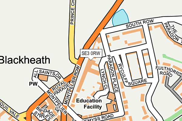
SE3 0RW is located in the Blackheath electoral ward, within the London borough of Lewisham and the English Parliamentary constituency of Lewisham East. The Sub Integrated Care Board (ICB) Location is NHS South East London ICB - 72Q and the police force is Metropolitan Police. This postcode has been in use since January 1980.


GetTheData
Source: OS OpenMap – Local (Ordnance Survey)
Source: OS VectorMap District (Ordnance Survey)
Licence: Open Government Licence (requires attribution)
| Easting | 539710 |
| Northing | 176331 |
| Latitude | 51.468707 |
| Longitude | 0.010008 |
GetTheData
Source: Open Postcode Geo
Licence: Open Government Licence
| Country | England |
| Postcode District | SE3 |
➜ See where SE3 is on a map ➜ Where is London? | |
GetTheData
Source: Land Registry Price Paid Data
Licence: Open Government Licence
Elevation or altitude of SE3 0RW as distance above sea level:
| Metres | Feet | |
|---|---|---|
| Elevation | 30m | 98ft |
Elevation is measured from the approximate centre of the postcode, to the nearest point on an OS contour line from OS Terrain 50, which has contour spacing of ten vertical metres.
➜ How high above sea level am I? Find the elevation of your current position using your device's GPS.
GetTheData
Source: Open Postcode Elevation
Licence: Open Government Licence
| Ward | Blackheath |
| Constituency | Lewisham East |
GetTheData
Source: ONS Postcode Database
Licence: Open Government Licence
| Montpelier Row | Blackheath | 48m |
| The Clarendon Hotel (Prince Charles Road) | Blackheath | 79m |
| The Clarendon Hotel (Prince Charles Road) | Blackheath | 83m |
| Montpelier Row (Prince Of Wales Road) | Blackheath | 152m |
| Royal Parade (Se3) (Royal Parade) | Blackheath | 204m |
| Cutty Sark (For Maritime Greenwich) Dlr Station (Creek Road) | Greenwich | 2,042m |
| Blackheath Station | 0.3km |
| Kidbrooke Station | 1.4km |
| Maze Hill Station | 1.6km |
GetTheData
Source: NaPTAN
Licence: Open Government Licence
GetTheData
Source: ONS Postcode Database
Licence: Open Government Licence


➜ Get more ratings from the Food Standards Agency
GetTheData
Source: Food Standards Agency
Licence: FSA terms & conditions
| Last Collection | |||
|---|---|---|---|
| Location | Mon-Fri | Sat | Distance |
| Blackheath Village | 17:30 | 12:00 | 274m |
| Post Office S E 3 0 A U | 17:30 | 12:00 | 300m |
| Grotes Place | 17:30 | 12:00 | 421m |
GetTheData
Source: Dracos
Licence: Creative Commons Attribution-ShareAlike
The below table lists the International Territorial Level (ITL) codes (formerly Nomenclature of Territorial Units for Statistics (NUTS) codes) and Local Administrative Units (LAU) codes for SE3 0RW:
| ITL 1 Code | Name |
|---|---|
| TLI | London |
| ITL 2 Code | Name |
| TLI4 | Inner London - East |
| ITL 3 Code | Name |
| TLI44 | Lewisham and Southwark |
| LAU 1 Code | Name |
| E09000023 | Lewisham |
GetTheData
Source: ONS Postcode Directory
Licence: Open Government Licence
The below table lists the Census Output Area (OA), Lower Layer Super Output Area (LSOA), and Middle Layer Super Output Area (MSOA) for SE3 0RW:
| Code | Name | |
|---|---|---|
| OA | E00016171 | |
| LSOA | E01003200 | Lewisham 009B |
| MSOA | E02000661 | Lewisham 009 |
GetTheData
Source: ONS Postcode Directory
Licence: Open Government Licence
| SE3 0RL | Montpelier Row | 60m |
| SE3 0SP | Paragon Place | 72m |
| SE3 0RX | South Row | 93m |
| SE3 0RU | South Row | 119m |
| SE3 0SN | Ryculff Square | 123m |
| SE3 0RS | Montpelier Row | 138m |
| SE3 0SW | Ryculff Square | 153m |
| SE3 0RT | Montpelier Row | 160m |
| SE3 0RY | South Row | 161m |
| SE3 0SE | Pond Road | 183m |
GetTheData
Source: Open Postcode Geo; Land Registry Price Paid Data
Licence: Open Government Licence