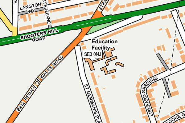
SE3 0NJ is located in the Blackheath Westcombe electoral ward, within the London borough of Greenwich and the English Parliamentary constituency of Greenwich and Woolwich. The Sub Integrated Care Board (ICB) Location is NHS South East London ICB - 72Q and the police force is Metropolitan Police. This postcode has been in use since January 1980.


GetTheData
Source: OS OpenMap – Local (Ordnance Survey)
Source: OS VectorMap District (Ordnance Survey)
Licence: Open Government Licence (requires attribution)
| Easting | 540090 |
| Northing | 176755 |
| Latitude | 51.472423 |
| Longitude | 0.015669 |
GetTheData
Source: Open Postcode Geo
Licence: Open Government Licence
| Country | England |
| Postcode District | SE3 |
➜ See where SE3 is on a map ➜ Where is London? | |
GetTheData
Source: Land Registry Price Paid Data
Licence: Open Government Licence
Elevation or altitude of SE3 0NJ as distance above sea level:
| Metres | Feet | |
|---|---|---|
| Elevation | 40m | 131ft |
Elevation is measured from the approximate centre of the postcode, to the nearest point on an OS contour line from OS Terrain 50, which has contour spacing of ten vertical metres.
➜ How high above sea level am I? Find the elevation of your current position using your device's GPS.
GetTheData
Source: Open Postcode Elevation
Licence: Open Government Licence
| Ward | Blackheath Westcombe |
| Constituency | Greenwich And Woolwich |
GetTheData
Source: ONS Postcode Database
Licence: Open Government Licence
| St Germans Place | Blackheath | 80m |
| St Germans Place (Prince Of Wales Road) | Blackheath | 136m |
| Stratheden Rdshooters Hill Rd | Kidbrooke | 196m |
| Shooters Hill Road Stratheden Road (Shooters Hill Road) | Kidbrooke | 208m |
| Stratheden Rdshooters Hill Rd (Stratheden Road) | Kidbrooke | 279m |
| Blackheath Station | 0.9km |
| Westcombe Park Station | 1.3km |
| Kidbrooke Station | 1.4km |
GetTheData
Source: NaPTAN
Licence: Open Government Licence
GetTheData
Source: ONS Postcode Database
Licence: Open Government Licence


➜ Get more ratings from the Food Standards Agency
GetTheData
Source: Food Standards Agency
Licence: FSA terms & conditions
| Last Collection | |||
|---|---|---|---|
| Location | Mon-Fri | Sat | Distance |
| 23 Shooters Hill Road | 17:30 | 12:00 | 144m |
| Liskeard Gardens | 17:30 | 12:00 | 299m |
| Kidbrooke Grove | 17:30 | 12:00 | 326m |
GetTheData
Source: Dracos
Licence: Creative Commons Attribution-ShareAlike
The below table lists the International Territorial Level (ITL) codes (formerly Nomenclature of Territorial Units for Statistics (NUTS) codes) and Local Administrative Units (LAU) codes for SE3 0NJ:
| ITL 1 Code | Name |
|---|---|
| TLI | London |
| ITL 2 Code | Name |
| TLI5 | Outer London - East and North East |
| ITL 3 Code | Name |
| TLI51 | Bexley and Greenwich |
| LAU 1 Code | Name |
| E09000011 | Greenwich |
GetTheData
Source: ONS Postcode Directory
Licence: Open Government Licence
The below table lists the Census Output Area (OA), Lower Layer Super Output Area (LSOA), and Middle Layer Super Output Area (MSOA) for SE3 0NJ:
| Code | Name | |
|---|---|---|
| OA | E00007850 | |
| LSOA | E01001583 | Greenwich 021C |
| MSOA | E02000333 | Greenwich 021 |
GetTheData
Source: ONS Postcode Directory
Licence: Open Government Licence
| SE3 0NH | St Germans Place | 35m |
| SE3 0NL | St Germans Place | 98m |
| SE3 7AS | Shooters Hill Road | 156m |
| SE3 0PE | Liskeard Gardens | 182m |
| SE3 0NN | St Germans Place | 184m |
| SE3 7TJ | Langton Way | 193m |
| SE3 7BD | Shooters Hill Road | 210m |
| SE3 7AR | Shooters Hill Road | 223m |
| SE3 7TL | Langton Way | 237m |
| SE3 0PN | Liskeard Gardens | 239m |
GetTheData
Source: Open Postcode Geo; Land Registry Price Paid Data
Licence: Open Government Licence