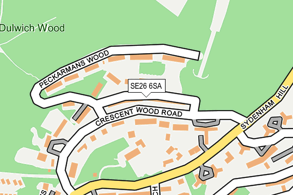
SE26 6SA lies on Crescent Wood Road in London. SE26 6SA is located in the Dulwich Wood electoral ward, within the London borough of Southwark and the English Parliamentary constituency of Dulwich and West Norwood. The Sub Integrated Care Board (ICB) Location is NHS South East London ICB - 72Q and the police force is Metropolitan Police. This postcode has been in use since January 1980.


GetTheData
Source: OS OpenMap – Local (Ordnance Survey)
Source: OS VectorMap District (Ordnance Survey)
Licence: Open Government Licence (requires attribution)
| Easting | 534223 |
| Northing | 172329 |
| Latitude | 51.434070 |
| Longitude | -0.070456 |
GetTheData
Source: Open Postcode Geo
Licence: Open Government Licence
| Street | Crescent Wood Road |
| Town/City | London |
| Country | England |
| Postcode District | SE26 |
➜ See where SE26 is on a map ➜ Where is London? | |
GetTheData
Source: Land Registry Price Paid Data
Licence: Open Government Licence
Elevation or altitude of SE26 6SA as distance above sea level:
| Metres | Feet | |
|---|---|---|
| Elevation | 100m | 328ft |
Elevation is measured from the approximate centre of the postcode, to the nearest point on an OS contour line from OS Terrain 50, which has contour spacing of ten vertical metres.
➜ How high above sea level am I? Find the elevation of your current position using your device's GPS.
GetTheData
Source: Open Postcode Elevation
Licence: Open Government Licence
| Ward | Dulwich Wood |
| Constituency | Dulwich And West Norwood |
GetTheData
Source: ONS Postcode Database
Licence: Open Government Licence
| Droitwich Close (Sydenham Hill) | Dulwich | 159m |
| Droitwich Close (Sydenham Hill) | Dulwich | 173m |
| Crescent Wood Road | Upper Sydenham | 205m |
| Crescent Wood Road | Upper Sydenham | 259m |
| Canbury Mews (Wells Park Road) | Upper Sydenham | 261m |
| Sydenham Hill Station | 0.7km |
| Forest Hill Station | 1.3km |
| Sydenham Station | 1.4km |
GetTheData
Source: NaPTAN
Licence: Open Government Licence
| Percentage of properties with Next Generation Access | 100.0% |
| Percentage of properties with Superfast Broadband | 100.0% |
| Percentage of properties with Ultrafast Broadband | 100.0% |
| Percentage of properties with Full Fibre Broadband | 0.0% |
Superfast Broadband is between 30Mbps and 300Mbps
Ultrafast Broadband is > 300Mbps
| Median download speed | 65.8Mbps |
| Average download speed | 69.6Mbps |
| Maximum download speed | 200.00Mbps |
| Median upload speed | 11.4Mbps |
| Average upload speed | 12.0Mbps |
| Maximum upload speed | 20.00Mbps |
| Percentage of properties unable to receive 2Mbps | 0.0% |
| Percentage of properties unable to receive 5Mbps | 0.0% |
| Percentage of properties unable to receive 10Mbps | 0.0% |
| Percentage of properties unable to receive 30Mbps | 0.0% |
GetTheData
Source: Ofcom
Licence: Ofcom Terms of Use (requires attribution)
Estimated total energy consumption in SE26 6SA by fuel type, 2015.
| Consumption (kWh) | 471,559 |
|---|---|
| Meter count | 23 |
| Mean (kWh/meter) | 20,503 |
| Median (kWh/meter) | 19,603 |
| Consumption (kWh) | 139,339 |
|---|---|
| Meter count | 24 |
| Mean (kWh/meter) | 5,806 |
| Median (kWh/meter) | 5,778 |
GetTheData
Source: Postcode level gas estimates: 2015 (experimental)
Source: Postcode level electricity estimates: 2015 (experimental)
Licence: Open Government Licence
GetTheData
Source: ONS Postcode Database
Licence: Open Government Licence


➜ Get more ratings from the Food Standards Agency
GetTheData
Source: Food Standards Agency
Licence: FSA terms & conditions
| Last Collection | |||
|---|---|---|---|
| Location | Mon-Fri | Sat | Distance |
| Crescent Wood Road | 17:30 | 12:00 | 147m |
| 24 Sydenham Hill | 17:30 | 12:00 | 287m |
| 42 Sydenham Hill | 17:30 | 12:00 | 410m |
GetTheData
Source: Dracos
Licence: Creative Commons Attribution-ShareAlike
The below table lists the International Territorial Level (ITL) codes (formerly Nomenclature of Territorial Units for Statistics (NUTS) codes) and Local Administrative Units (LAU) codes for SE26 6SA:
| ITL 1 Code | Name |
|---|---|
| TLI | London |
| ITL 2 Code | Name |
| TLI4 | Inner London - East |
| ITL 3 Code | Name |
| TLI44 | Lewisham and Southwark |
| LAU 1 Code | Name |
| E09000028 | Southwark |
GetTheData
Source: ONS Postcode Directory
Licence: Open Government Licence
The below table lists the Census Output Area (OA), Lower Layer Super Output Area (LSOA), and Middle Layer Super Output Area (MSOA) for SE26 6SA:
| Code | Name | |
|---|---|---|
| OA | E00019878 | |
| LSOA | E01003945 | Southwark 033A |
| MSOA | E02000839 | Southwark 033 |
GetTheData
Source: ONS Postcode Directory
Licence: Open Government Licence
| SE26 6RU | Crescent Wood Road | 51m |
| SE26 6RZ | Peckarmans Wood | 54m |
| SE26 6RY | Peckarmans Wood | 105m |
| SE26 6TQ | Sydenham Hill | 138m |
| SE26 6SB | Crescent Wood Road | 140m |
| SE26 6RX | Peckarmans Wood | 157m |
| SE26 6TN | Droitwich Close | 189m |
| SE26 6TL | Droitwich Close | 201m |
| SE26 6TR | Sydenham Hill | 202m |
| SE26 6RT | Crescent Wood Road | 203m |
GetTheData
Source: Open Postcode Geo; Land Registry Price Paid Data
Licence: Open Government Licence