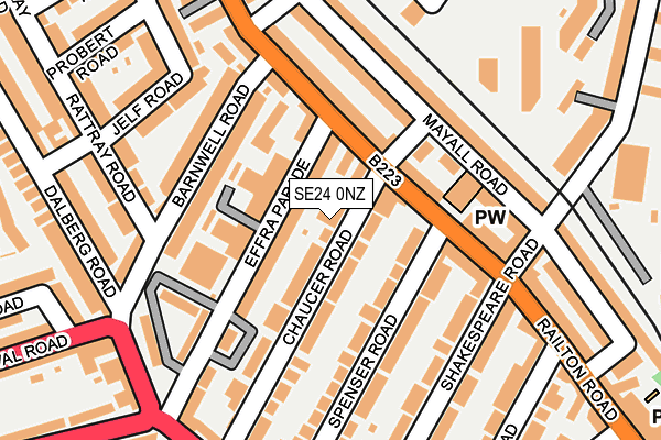
SE24 0NZ lies on Chaucer Road in Herne Hill, London. SE24 0NZ is located in the Herne Hill & Loughborough Junction electoral ward, within the London borough of Lambeth and the English Parliamentary constituency of Dulwich and West Norwood. The Sub Integrated Care Board (ICB) Location is NHS South East London ICB - 72Q and the police force is Metropolitan Police. This postcode has been in use since January 1980.


GetTheData
Source: OS OpenMap – Local (Ordnance Survey)
Source: OS VectorMap District (Ordnance Survey)
Licence: Open Government Licence (requires attribution)
| Easting | 531523 |
| Northing | 174822 |
| Latitude | 51.457106 |
| Longitude | -0.108350 |
GetTheData
Source: Open Postcode Geo
Licence: Open Government Licence
| Street | Chaucer Road |
| Locality | Herne Hill |
| Town/City | London |
| Country | England |
| Postcode District | SE24 |
➜ See where SE24 is on a map ➜ Where is London? | |
GetTheData
Source: Land Registry Price Paid Data
Licence: Open Government Licence
Elevation or altitude of SE24 0NZ as distance above sea level:
| Metres | Feet | |
|---|---|---|
| Elevation | 20m | 66ft |
Elevation is measured from the approximate centre of the postcode, to the nearest point on an OS contour line from OS Terrain 50, which has contour spacing of ten vertical metres.
➜ How high above sea level am I? Find the elevation of your current position using your device's GPS.
GetTheData
Source: Open Postcode Elevation
Licence: Open Government Licence
| Ward | Herne Hill & Loughborough Junction |
| Constituency | Dulwich And West Norwood |
GetTheData
Source: ONS Postcode Database
Licence: Open Government Licence
| Effra Parade | Brixton | 86m |
| Effra Parade | Brixton | 126m |
| Dalberg Road Effra Parade (Dalberg Road) | Brixton | 220m |
| Chaucer Road Effra Parade (Dulwich Road) | Brixton | 244m |
| Loughborough Park Elveden House | Brixton | 255m |
| Brixton Underground Station | Brixton | 763m |
| Herne Hill Station | 0.6km |
| Brixton Station | 0.8km |
| Loughborough Junction Station | 1.1km |
GetTheData
Source: NaPTAN
Licence: Open Government Licence
| Percentage of properties with Next Generation Access | 100.0% |
| Percentage of properties with Superfast Broadband | 100.0% |
| Percentage of properties with Ultrafast Broadband | 100.0% |
| Percentage of properties with Full Fibre Broadband | 0.0% |
Superfast Broadband is between 30Mbps and 300Mbps
Ultrafast Broadband is > 300Mbps
| Percentage of properties unable to receive 2Mbps | 0.0% |
| Percentage of properties unable to receive 5Mbps | 0.0% |
| Percentage of properties unable to receive 10Mbps | 0.0% |
| Percentage of properties unable to receive 30Mbps | 0.0% |
GetTheData
Source: Ofcom
Licence: Ofcom Terms of Use (requires attribution)
Estimated total energy consumption in SE24 0NZ by fuel type, 2015.
| Consumption (kWh) | 12,362 |
|---|---|
| Meter count | 6 |
| Mean (kWh/meter) | 2,060 |
| Median (kWh/meter) | 1,834 |
GetTheData
Source: Postcode level gas estimates: 2015 (experimental)
Source: Postcode level electricity estimates: 2015 (experimental)
Licence: Open Government Licence
GetTheData
Source: ONS Postcode Database
Licence: Open Government Licence


➜ Get more ratings from the Food Standards Agency
GetTheData
Source: Food Standards Agency
Licence: FSA terms & conditions
| Last Collection | |||
|---|---|---|---|
| Location | Mon-Fri | Sat | Distance |
| Kimberley Road | 17:30 | 12:00 | 73m |
| 127 Railton Road | 17:30 | 12:00 | 178m |
| 2 Effra Parade | 17:30 | 12:00 | 230m |
GetTheData
Source: Dracos
Licence: Creative Commons Attribution-ShareAlike
The below table lists the International Territorial Level (ITL) codes (formerly Nomenclature of Territorial Units for Statistics (NUTS) codes) and Local Administrative Units (LAU) codes for SE24 0NZ:
| ITL 1 Code | Name |
|---|---|
| TLI | London |
| ITL 2 Code | Name |
| TLI4 | Inner London - East |
| ITL 3 Code | Name |
| TLI45 | Lambeth |
| LAU 1 Code | Name |
| E09000022 | Lambeth |
GetTheData
Source: ONS Postcode Directory
Licence: Open Government Licence
The below table lists the Census Output Area (OA), Lower Layer Super Output Area (LSOA), and Middle Layer Super Output Area (MSOA) for SE24 0NZ:
| Code | Name | |
|---|---|---|
| OA | E00171524 | |
| LSOA | E01003071 | Lambeth 018D |
| MSOA | E02000635 | Lambeth 018 |
GetTheData
Source: ONS Postcode Directory
Licence: Open Government Licence
| SE24 0NY | Chaucer Road | 35m |
| SW2 1PR | Effra Parade | 38m |
| SE24 0LD | Railton Road | 71m |
| SW2 1PG | Effra Parade | 74m |
| SE24 0NU | Chaucer Road | 87m |
| SW2 1PF | Effra Parade | 91m |
| SE24 0LG | Railton Road | 96m |
| SE24 0LT | Railton Road | 103m |
| SE24 0NX | Chaucer Road | 105m |
| SE24 0NS | Spenser Road | 113m |
GetTheData
Source: Open Postcode Geo; Land Registry Price Paid Data
Licence: Open Government Licence