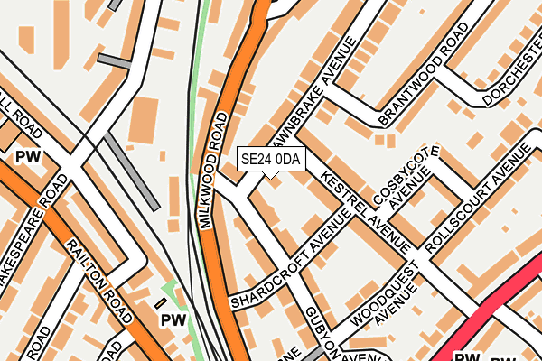
SE24 0DA lies on Fawnbrake Avenue in London. SE24 0DA is located in the Herne Hill & Loughborough Junction electoral ward, within the London borough of Lambeth and the English Parliamentary constituency of Dulwich and West Norwood. The Sub Integrated Care Board (ICB) Location is NHS South East London ICB - 72Q and the police force is Metropolitan Police. This postcode has been in use since January 1980.


GetTheData
Source: OS OpenMap – Local (Ordnance Survey)
Source: OS VectorMap District (Ordnance Survey)
Licence: Open Government Licence (requires attribution)
| Easting | 531937 |
| Northing | 174798 |
| Latitude | 51.456795 |
| Longitude | -0.102378 |
GetTheData
Source: Open Postcode Geo
Licence: Open Government Licence
| Street | Fawnbrake Avenue |
| Town/City | London |
| Country | England |
| Postcode District | SE24 |
➜ See where SE24 is on a map ➜ Where is London? | |
GetTheData
Source: Land Registry Price Paid Data
Licence: Open Government Licence
Elevation or altitude of SE24 0DA as distance above sea level:
| Metres | Feet | |
|---|---|---|
| Elevation | 30m | 98ft |
Elevation is measured from the approximate centre of the postcode, to the nearest point on an OS contour line from OS Terrain 50, which has contour spacing of ten vertical metres.
➜ How high above sea level am I? Find the elevation of your current position using your device's GPS.
GetTheData
Source: Open Postcode Elevation
Licence: Open Government Licence
| Ward | Herne Hill & Loughborough Junction |
| Constituency | Dulwich And West Norwood |
GetTheData
Source: ONS Postcode Database
Licence: Open Government Licence
| Regent Road (Se24) | Herne Hill | 233m |
| Regent Road (Se24) | Herne Hill | 252m |
| St Paul's Church (Se24) | Herne Hill | 279m |
| Hollingbourne Road (Herne Hill) | Brixton | 283m |
| Hollingbourne Road | Brixton | 333m |
| Brixton Underground Station | Brixton | 1,083m |
| Herne Hill Station | 0.4km |
| North Dulwich Station | 1km |
| Loughborough Junction Station | 1.1km |
GetTheData
Source: NaPTAN
Licence: Open Government Licence
| Percentage of properties with Next Generation Access | 100.0% |
| Percentage of properties with Superfast Broadband | 100.0% |
| Percentage of properties with Ultrafast Broadband | 100.0% |
| Percentage of properties with Full Fibre Broadband | 0.0% |
Superfast Broadband is between 30Mbps and 300Mbps
Ultrafast Broadband is > 300Mbps
| Percentage of properties unable to receive 2Mbps | 0.0% |
| Percentage of properties unable to receive 5Mbps | 0.0% |
| Percentage of properties unable to receive 10Mbps | 0.0% |
| Percentage of properties unable to receive 30Mbps | 0.0% |
GetTheData
Source: Ofcom
Licence: Ofcom Terms of Use (requires attribution)
GetTheData
Source: ONS Postcode Database
Licence: Open Government Licence


➜ Get more ratings from the Food Standards Agency
GetTheData
Source: Food Standards Agency
Licence: FSA terms & conditions
| Last Collection | |||
|---|---|---|---|
| Location | Mon-Fri | Sat | Distance |
| Milkwood Road | 17:30 | 12:00 | 134m |
| Milkwood Road | 17:30 | 12:00 | 160m |
| Fawn Brake Avenue | 17:30 | 12:00 | 223m |
GetTheData
Source: Dracos
Licence: Creative Commons Attribution-ShareAlike
The below table lists the International Territorial Level (ITL) codes (formerly Nomenclature of Territorial Units for Statistics (NUTS) codes) and Local Administrative Units (LAU) codes for SE24 0DA:
| ITL 1 Code | Name |
|---|---|
| TLI | London |
| ITL 2 Code | Name |
| TLI4 | Inner London - East |
| ITL 3 Code | Name |
| TLI45 | Lambeth |
| LAU 1 Code | Name |
| E09000022 | Lambeth |
GetTheData
Source: ONS Postcode Directory
Licence: Open Government Licence
The below table lists the Census Output Area (OA), Lower Layer Super Output Area (LSOA), and Middle Layer Super Output Area (MSOA) for SE24 0DA:
| Code | Name | |
|---|---|---|
| OA | E00015518 | |
| LSOA | E01003073 | Lambeth 014B |
| MSOA | E02000631 | Lambeth 014 |
GetTheData
Source: ONS Postcode Directory
Licence: Open Government Licence
| SE24 0DS | Shardcroft Avenue | 68m |
| SE24 0DX | Gubyon Avenue | 74m |
| SE24 0EB | Kestrel Avenue | 80m |
| SE24 0HE | Milkwood Road | 94m |
| SE24 0ED | Kestrel Avenue | 103m |
| SE24 0DT | Shardcroft Avenue | 109m |
| SE24 0JE | Milkwood Road | 119m |
| SE24 0BE | Fawnbrake Avenue | 126m |
| SE24 0DU | Gubyon Avenue | 143m |
| SE24 0AT | Robert Burns Mews | 156m |
GetTheData
Source: Open Postcode Geo; Land Registry Price Paid Data
Licence: Open Government Licence