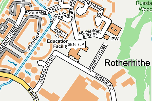
SE16 7LP is located in the Rotherhithe electoral ward, within the London borough of Southwark and the English Parliamentary constituency of Bermondsey and Old Southwark. The Sub Integrated Care Board (ICB) Location is NHS South East London ICB - 72Q and the police force is Metropolitan Police. This postcode has been in use since December 1999.


GetTheData
Source: OS OpenMap – Local (Ordnance Survey)
Source: OS VectorMap District (Ordnance Survey)
Licence: Open Government Licence (requires attribution)
| Easting | 535897 |
| Northing | 179666 |
| Latitude | 51.499604 |
| Longitude | -0.043571 |
GetTheData
Source: Open Postcode Geo
Licence: Open Government Licence
| Country | England |
| Postcode District | SE16 |
➜ See where SE16 is on a map ➜ Where is London? | |
GetTheData
Source: Land Registry Price Paid Data
Licence: Open Government Licence
Elevation or altitude of SE16 7LP as distance above sea level:
| Metres | Feet | |
|---|---|---|
| Elevation | 10m | 33ft |
Elevation is measured from the approximate centre of the postcode, to the nearest point on an OS contour line from OS Terrain 50, which has contour spacing of ten vertical metres.
➜ How high above sea level am I? Find the elevation of your current position using your device's GPS.
GetTheData
Source: Open Postcode Elevation
Licence: Open Government Licence
| Ward | Rotherhithe |
| Constituency | Bermondsey And Old Southwark |
GetTheData
Source: ONS Postcode Database
Licence: Open Government Licence
| Canada Street | Canada Water | 237m |
| Canada Street (Surrey Quays Road) | Canada Water | 278m |
| Brunswick Quay (Redriff Road) | Surrey Quays | 417m |
| Onega Gate (Redriff Road) | Surrey Quays | 436m |
| Onega Gate (Redriff Road) | Surrey Quays | 453m |
| Canada Water Underground Station | Canada Water | 465m |
| Bermondsey Underground Station | Bermondsey | 1,414m |
| Limehouse Dlr Station (Commercial Road) | Limehouse | 1,446m |
| Westferry Dlr Station (Westferry Road) | Westferry | 1,600m |
| Shadwell Dlr Station (Martha Street) | Shadwell | 1,622m |
| Canada Water Station | 0.5km |
| Rotherhithe Station | 0.6km |
| Surrey Quays Station | 0.8km |
GetTheData
Source: NaPTAN
Licence: Open Government Licence
GetTheData
Source: ONS Postcode Database
Licence: Open Government Licence

➜ Get more ratings from the Food Standards Agency
GetTheData
Source: Food Standards Agency
Licence: FSA terms & conditions
| Last Collection | |||
|---|---|---|---|
| Location | Mon-Fri | Sat | Distance |
| Timber Pond Road | 17:30 | 12:00 | 185m |
| 223 Redriff Road | 17:30 | 12:00 | 419m |
| Salter Road | 17:30 | 12:00 | 487m |
GetTheData
Source: Dracos
Licence: Creative Commons Attribution-ShareAlike
The below table lists the International Territorial Level (ITL) codes (formerly Nomenclature of Territorial Units for Statistics (NUTS) codes) and Local Administrative Units (LAU) codes for SE16 7LP:
| ITL 1 Code | Name |
|---|---|
| TLI | London |
| ITL 2 Code | Name |
| TLI4 | Inner London - East |
| ITL 3 Code | Name |
| TLI44 | Lewisham and Southwark |
| LAU 1 Code | Name |
| E09000028 | Southwark |
GetTheData
Source: ONS Postcode Directory
Licence: Open Government Licence
The below table lists the Census Output Area (OA), Lower Layer Super Output Area (LSOA), and Middle Layer Super Output Area (MSOA) for SE16 7LP:
| Code | Name | |
|---|---|---|
| OA | E00020307 | |
| LSOA | E01004032 | Southwark 001B |
| MSOA | E02000807 | Southwark 001 |
GetTheData
Source: ONS Postcode Directory
Licence: Open Government Licence
| SE16 6RT | Hardy Close | 76m |
| SE16 6SW | Canada Street | 79m |
| SE16 6AU | Timber Pond Road | 89m |
| SE16 6AB | Archangel Street | 95m |
| SE16 6RS | Drake Close | 101m |
| SE16 6SF | Wolfe Crescent | 104m |
| SE16 6SH | Wolfe Crescent | 121m |
| SE16 6RZ | Middleton Drive | 126m |
| SE16 6SP | Wolfe Crescent | 132m |
| SE16 6SB | Maple Leaf Square | 132m |
GetTheData
Source: Open Postcode Geo; Land Registry Price Paid Data
Licence: Open Government Licence