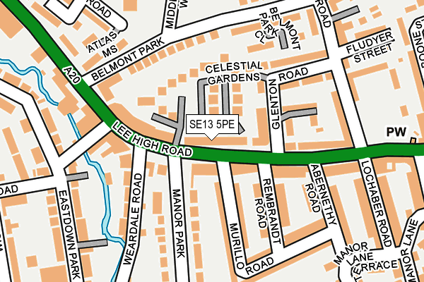
SE13 5PE lies on Lee High Road in London. SE13 5PE is located in the Blackheath electoral ward, within the London borough of Lewisham and the English Parliamentary constituency of Lewisham East. The Sub Integrated Care Board (ICB) Location is NHS South East London ICB - 72Q and the police force is Metropolitan Police. This postcode has been in use since January 1980.


GetTheData
Source: OS OpenMap – Local (Ordnance Survey)
Source: OS VectorMap District (Ordnance Survey)
Licence: Open Government Licence (requires attribution)
| Easting | 538965 |
| Northing | 175209 |
| Latitude | 51.458808 |
| Longitude | -0.001152 |
GetTheData
Source: Open Postcode Geo
Licence: Open Government Licence
| Street | Lee High Road |
| Town/City | London |
| Country | England |
| Postcode District | SE13 |
➜ See where SE13 is on a map ➜ Where is London? | |
GetTheData
Source: Land Registry Price Paid Data
Licence: Open Government Licence
Elevation or altitude of SE13 5PE as distance above sea level:
| Metres | Feet | |
|---|---|---|
| Elevation | 20m | 66ft |
Elevation is measured from the approximate centre of the postcode, to the nearest point on an OS contour line from OS Terrain 50, which has contour spacing of ten vertical metres.
➜ How high above sea level am I? Find the elevation of your current position using your device's GPS.
GetTheData
Source: Open Postcode Elevation
Licence: Open Government Licence
| Ward | Blackheath |
| Constituency | Lewisham East |
GetTheData
Source: ONS Postcode Database
Licence: Open Government Licence
| Manor Park (Lee High Road) | Lee | 25m |
| Manor Road Lee High Road | Lewisham | 77m |
| Manor Road Lee High Road | Lewisham | 87m |
| Brandram Road (Lee High Road) | Lee | 165m |
| Belmont Park (Lee High Road) | Lewisham | 170m |
| Lewisham Dlr Station (Loampit Vale) | Lewisham | 1,043m |
| Elverson Road Dlr Station (Elverson Road) | Elverson Road | 1,573m |
| Hither Green Station | 0.8km |
| Blackheath Station | 1km |
| Lewisham Station | 1.2km |
GetTheData
Source: NaPTAN
Licence: Open Government Licence
| Median download speed | 50.0Mbps |
| Average download speed | 64.2Mbps |
| Maximum download speed | 350.00Mbps |
| Median upload speed | 1.2Mbps |
| Average upload speed | 1.0Mbps |
| Maximum upload speed | 1.27Mbps |
GetTheData
Source: Ofcom
Licence: Ofcom Terms of Use (requires attribution)
Estimated total energy consumption in SE13 5PE by fuel type, 2015.
| Consumption (kWh) | 30,914 |
|---|---|
| Meter count | 26 |
| Mean (kWh/meter) | 1,189 |
| Median (kWh/meter) | 507 |
| Consumption (kWh) | 114,220 |
|---|---|
| Meter count | 47 |
| Mean (kWh/meter) | 2,430 |
| Median (kWh/meter) | 1,699 |
GetTheData
Source: Postcode level gas estimates: 2015 (experimental)
Source: Postcode level electricity estimates: 2015 (experimental)
Licence: Open Government Licence
GetTheData
Source: ONS Postcode Database
Licence: Open Government Licence


➜ Get more ratings from the Food Standards Agency
GetTheData
Source: Food Standards Agency
Licence: FSA terms & conditions
| Last Collection | |||
|---|---|---|---|
| Location | Mon-Fri | Sat | Distance |
| Rembrandt Road | 17:30 | 12:00 | 87m |
| Post Office | 17:30 | 12:00 | 93m |
| Brandram Road | 17:30 | 12:00 | 212m |
GetTheData
Source: Dracos
Licence: Creative Commons Attribution-ShareAlike
The below table lists the International Territorial Level (ITL) codes (formerly Nomenclature of Territorial Units for Statistics (NUTS) codes) and Local Administrative Units (LAU) codes for SE13 5PE:
| ITL 1 Code | Name |
|---|---|
| TLI | London |
| ITL 2 Code | Name |
| TLI4 | Inner London - East |
| ITL 3 Code | Name |
| TLI44 | Lewisham and Southwark |
| LAU 1 Code | Name |
| E09000023 | Lewisham |
GetTheData
Source: ONS Postcode Directory
Licence: Open Government Licence
The below table lists the Census Output Area (OA), Lower Layer Super Output Area (LSOA), and Middle Layer Super Output Area (MSOA) for SE13 5PE:
| Code | Name | |
|---|---|---|
| OA | E00016193 | |
| LSOA | E01003203 | Lewisham 009D |
| MSOA | E02000661 | Lewisham 009 |
GetTheData
Source: ONS Postcode Directory
Licence: Open Government Licence
| SE13 5RU | Celestial Gardens | 54m |
| SE13 5PA | Halley Gardens | 102m |
| SE13 5PB | Manor Park Parade | 104m |
| SE13 5RP | Celestial Gardens | 106m |
| SE13 5PL | Lee High Road | 111m |
| SE13 5QF | Murillo Road | 112m |
| SE13 5QH | Rembrandt Road | 117m |
| SE13 5PZ | Waterside Court | 129m |
| SE13 5RR | Callaghan Close | 133m |
| SE13 5QE | Murillo Road | 137m |
GetTheData
Source: Open Postcode Geo; Land Registry Price Paid Data
Licence: Open Government Licence