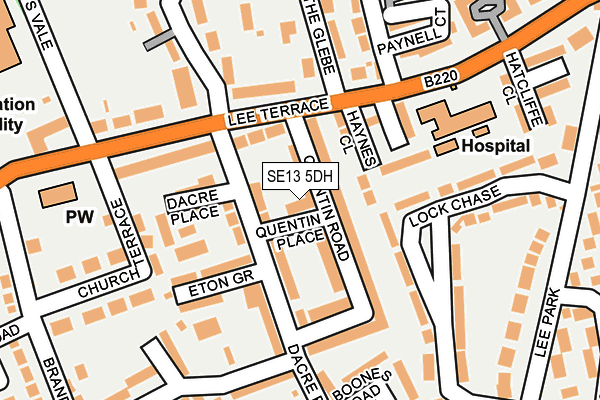
SE13 5DH is located in the Blackheath electoral ward, within the London borough of Lewisham and the English Parliamentary constituency of Lewisham East. The Sub Integrated Care Board (ICB) Location is NHS South East London ICB - 72Q and the police force is Metropolitan Police. This postcode has been in use since January 1980.


GetTheData
Source: OS OpenMap – Local (Ordnance Survey)
Source: OS VectorMap District (Ordnance Survey)
Licence: Open Government Licence (requires attribution)
| Easting | 539326 |
| Northing | 175648 |
| Latitude | 51.462664 |
| Longitude | 0.004240 |
GetTheData
Source: Open Postcode Geo
Licence: Open Government Licence
| Country | England |
| Postcode District | SE13 |
➜ See where SE13 is on a map ➜ Where is London? | |
GetTheData
Source: Land Registry Price Paid Data
Licence: Open Government Licence
Elevation or altitude of SE13 5DH as distance above sea level:
| Metres | Feet | |
|---|---|---|
| Elevation | 30m | 98ft |
Elevation is measured from the approximate centre of the postcode, to the nearest point on an OS contour line from OS Terrain 50, which has contour spacing of ten vertical metres.
➜ How high above sea level am I? Find the elevation of your current position using your device's GPS.
GetTheData
Source: Open Postcode Elevation
Licence: Open Government Licence
| Ward | Blackheath |
| Constituency | Lewisham East |
GetTheData
Source: ONS Postcode Database
Licence: Open Government Licence
| Blackheath Hospital (Lee Terrace) | Blackheath | 189m |
| Blackheath Hospital (Lee Terrace) | Blackheath | 239m |
| St Margaret's Church Brandram Road (Lee Terrace) | Blackheath | 240m |
| St Margaret's Church Brandram Road (Lee Terrace) | Blackheath | 291m |
| Priory Park Lee Road | Blackheath | 391m |
| Lewisham Dlr Station (Loampit Vale) | Lewisham | 1,208m |
| Elverson Road Dlr Station (Elverson Road) | Elverson Road | 1,620m |
| Blackheath Station | 0.5km |
| Hither Green Station | 1.2km |
| Lewisham Station | 1.3km |
GetTheData
Source: NaPTAN
Licence: Open Government Licence
| Percentage of properties with Next Generation Access | 100.0% |
| Percentage of properties with Superfast Broadband | 100.0% |
| Percentage of properties with Ultrafast Broadband | 100.0% |
| Percentage of properties with Full Fibre Broadband | 0.0% |
Superfast Broadband is between 30Mbps and 300Mbps
Ultrafast Broadband is > 300Mbps
| Percentage of properties unable to receive 2Mbps | 0.0% |
| Percentage of properties unable to receive 5Mbps | 0.0% |
| Percentage of properties unable to receive 10Mbps | 0.0% |
| Percentage of properties unable to receive 30Mbps | 0.0% |
GetTheData
Source: Ofcom
Licence: Ofcom Terms of Use (requires attribution)
GetTheData
Source: ONS Postcode Database
Licence: Open Government Licence


➜ Get more ratings from the Food Standards Agency
GetTheData
Source: Food Standards Agency
Licence: FSA terms & conditions
| Last Collection | |||
|---|---|---|---|
| Location | Mon-Fri | Sat | Distance |
| Dacre Park | 17:30 | 12:00 | 99m |
| Church Terrace | 17:30 | 12:00 | 241m |
| The Glebe | 17:30 | 12:00 | 242m |
GetTheData
Source: Dracos
Licence: Creative Commons Attribution-ShareAlike
The below table lists the International Territorial Level (ITL) codes (formerly Nomenclature of Territorial Units for Statistics (NUTS) codes) and Local Administrative Units (LAU) codes for SE13 5DH:
| ITL 1 Code | Name |
|---|---|
| TLI | London |
| ITL 2 Code | Name |
| TLI4 | Inner London - East |
| ITL 3 Code | Name |
| TLI44 | Lewisham and Southwark |
| LAU 1 Code | Name |
| E09000023 | Lewisham |
GetTheData
Source: ONS Postcode Directory
Licence: Open Government Licence
The below table lists the Census Output Area (OA), Lower Layer Super Output Area (LSOA), and Middle Layer Super Output Area (MSOA) for SE13 5DH:
| Code | Name | |
|---|---|---|
| OA | E00016187 | |
| LSOA | E01003198 | Lewisham 009A |
| MSOA | E02000661 | Lewisham 009 |
GetTheData
Source: ONS Postcode Directory
Licence: Open Government Licence
| SE13 5DQ | Quentin Road | 55m |
| SE13 5DD | Dacre Park | 62m |
| SE13 5BZ | Dacre Park | 64m |
| SE3 9UA | Haynes Close | 76m |
| SE13 5DF | Quentin Road | 81m |
| SE13 5DG | Quentin Road | 107m |
| SE13 5DJ | Dacre Place | 109m |
| SE13 5BY | Eton Grove | 111m |
| SE3 9TZ | Lee Terrace | 112m |
| SE3 9TF | Lee Terrace | 124m |
GetTheData
Source: Open Postcode Geo; Land Registry Price Paid Data
Licence: Open Government Licence