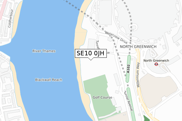
SE10 0JH is located in the Greenwich Peninsula electoral ward, within the London borough of Greenwich and the English Parliamentary constituency of Greenwich and Woolwich. The Sub Integrated Care Board (ICB) Location is NHS South East London ICB - 72Q and the police force is Metropolitan Police. This postcode has been in use since September 2019.


GetTheData
Source: OS Open Zoomstack (Ordnance Survey)
Licence: Open Government Licence (requires attribution)
Attribution: Contains OS data © Crown copyright and database right 2024
Source: Open Postcode Geo
Licence: Open Government Licence (requires attribution)
Attribution: Contains OS data © Crown copyright and database right 2024; Contains Royal Mail data © Royal Mail copyright and database right 2024; Source: Office for National Statistics licensed under the Open Government Licence v.3.0
| Easting | 538826 |
| Northing | 179913 |
| Latitude | 51.501113 |
| Longitude | -0.001277 |
GetTheData
Source: Open Postcode Geo
Licence: Open Government Licence
| Country | England |
| Postcode District | SE10 |
| ➜ SE10 open data dashboard ➜ See where SE10 is on a map ➜ Where is London? | |
GetTheData
Source: Land Registry Price Paid Data
Licence: Open Government Licence
| Ward | Greenwich Peninsula |
| Constituency | Greenwich And Woolwich |
GetTheData
Source: ONS Postcode Database
Licence: Open Government Licence
| June 2022 | Robbery | On or near Shopping Area | 226m |
| June 2022 | Robbery | On or near Shopping Area | 226m |
| June 2022 | Robbery | On or near Shopping Area | 226m |
| ➜ Get more crime data in our Crime section | |||
GetTheData
Source: data.police.uk
Licence: Open Government Licence
| North Greenwich Station | North Greenwich | 260m |
| North Greenwich Station | North Greenwich | 287m |
| North Greenwich Station | North Greenwich | 295m |
| North Greenwich Station | North Greenwich | 300m |
| North Greenwich Station | North Greenwich | 307m |
| North Greenwich Underground Station | North Greenwich | 395m |
| Emirates Greenwich Peninsula (East Parkside) | North Greenwich | 691m |
| Blackwall Dlr Station (Preston's Road) | Blackwall | 860m |
| East India Dlr Station (Aspen Way) | East India | 920m |
| South Quay Dlr Station (Marsh Wall) | South Quay | 1,036m |
| Maze Hill Station | 2.1km |
| Westcombe Park Station | 2.3km |
| Greenwich Station | 2.7km |
GetTheData
Source: NaPTAN
Licence: Open Government Licence
GetTheData
Source: ONS Postcode Database
Licence: Open Government Licence


➜ Get more ratings from the Food Standards Agency
GetTheData
Source: Food Standards Agency
Licence: FSA terms & conditions
| Last Collection | |||
|---|---|---|---|
| Location | Mon-Fri | Sat | Distance |
| Prestons Road | 17:30 | 11:30 | 523m |
| Wood Wharf Business Park | 19:00 | 528m | |
| 15 Castalia Square E14 | 19:00 | 12:00 | 704m |
GetTheData
Source: Dracos
Licence: Creative Commons Attribution-ShareAlike
| Facility | Distance |
|---|---|
| Greenwich Peninsula Golf Range Tunnel Avenue, London Golf | 288m |
| Better Gym North Greenwich (Closed) Green Place, London Health and Fitness Gym | 569m |
| In2sports Harbord Square, London Sports Hall | 620m |
GetTheData
Source: Active Places
Licence: Open Government Licence
| School | Phase of Education | Distance |
|---|---|---|
| Ravensbourne 6 Penrose Way, London, SE10 0EW | Not applicable | 456m |
| Mulberry Wood Wharf Primary School 20 Brannan Street, Tower Hamlets, London, E14 9ZR | Primary | 591m |
| Tabangao School C/O Fieldwork Education Limited, 30 Skylines Village, Limeharbour, London, E14 9TS | Not applicable | 818m |
GetTheData
Source: Edubase
Licence: Open Government Licence
| Risk of SE10 0JH flooding from rivers and sea | Very Low |
| ➜ SE10 0JH flood map | |
GetTheData
Source: Open Flood Risk by Postcode
Licence: Open Government Licence
The below table lists the International Territorial Level (ITL) codes (formerly Nomenclature of Territorial Units for Statistics (NUTS) codes) and Local Administrative Units (LAU) codes for SE10 0JH:
| ITL 1 Code | Name |
|---|---|
| TLI | London |
| ITL 2 Code | Name |
| TLI5 | Outer London - East and North East |
| ITL 3 Code | Name |
| TLI51 | Bexley and Greenwich |
| LAU 1 Code | Name |
| E09000011 | Greenwich |
GetTheData
Source: ONS Postcode Directory
Licence: Open Government Licence
The below table lists the Census Output Area (OA), Lower Layer Super Output Area (LSOA), and Middle Layer Super Output Area (MSOA) for SE10 0JH:
| Code | Name | |
|---|---|---|
| OA | E00008308 | |
| LSOA | E01001667 | Greenwich 036B |
| MSOA | E02006929 | Greenwich 036 |
GetTheData
Source: ONS Postcode Directory
Licence: Open Government Licence
| E14 9NU | Coldharbour | 457m |
| E14 9NS | Coldharbour | 458m |
| E14 3FB | Manchester Road | 463m |
| E14 9NT | Coldharbour | 483m |
| E14 3EX | Stewart Street | 490m |
| E14 3YH | Folly Wall | 495m |
| E14 9NL | Coldharbour | 495m |
| E14 3FD | Manchester Road | 513m |
| E14 9NY | Vantage Mews | 517m |
| E14 3EU | Capstan Square | 521m |
GetTheData
Source: Open Postcode Geo; Land Registry Price Paid Data
Licence: Open Government Licence