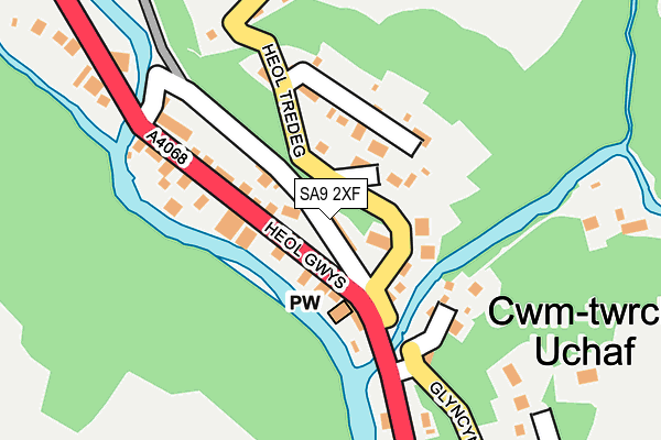
SA9 2XF lies on Gwysfryn in Upper Cwmtwrch, Swansea. SA9 2XF is located in the Cwm-twrch electoral ward, within the unitary authority of Powys and the Welsh Parliamentary constituency of Brecon and Radnorshire. The Local Health Board is Powys Teaching and the police force is Dyfed-Powys. This postcode has been in use since March 1982.


GetTheData
Source: OS OpenMap – Local (Ordnance Survey)
Source: OS VectorMap District (Ordnance Survey)
Licence: Open Government Licence (requires attribution)
| Easting | 275665 |
| Northing | 211374 |
| Latitude | 51.787166 |
| Longitude | -3.804012 |
GetTheData
Source: Open Postcode Geo
Licence: Open Government Licence
| Street | Gwysfryn |
| Locality | Upper Cwmtwrch |
| Town/City | Swansea |
| Country | Wales |
| Postcode District | SA9 |
➜ See where SA9 is on a map ➜ Where is Cwm-twrch Uchaf? | |
GetTheData
Source: Land Registry Price Paid Data
Licence: Open Government Licence
Elevation or altitude of SA9 2XF as distance above sea level:
| Metres | Feet | |
|---|---|---|
| Elevation | 120m | 394ft |
Elevation is measured from the approximate centre of the postcode, to the nearest point on an OS contour line from OS Terrain 50, which has contour spacing of ten vertical metres.
➜ How high above sea level am I? Find the elevation of your current position using your device's GPS.
GetTheData
Source: Open Postcode Elevation
Licence: Open Government Licence
| Ward | Cwm-twrch |
| Constituency | Brecon And Radnorshire |
GetTheData
Source: ONS Postcode Database
Licence: Open Government Licence
| New Tredegar Arms (Heol Gwys) | Upper Cwm-twrch | 37m |
| New Tredegar Arms (Heol Gwys) | Upper Cwm-twrch | 58m |
| Cwmtwrch Rugby Club (Heol Gwys) | Upper Cwm-twrch | 185m |
| Cwmtwrch Rugby Club (Heol Tredeg) | Cwmtwrch Uchaf | 187m |
| Berrington Hill (Heol Gwys) | Ystradowen | 370m |
GetTheData
Source: NaPTAN
Licence: Open Government Licence
| Percentage of properties with Next Generation Access | 100.0% |
| Percentage of properties with Superfast Broadband | 10.0% |
| Percentage of properties with Ultrafast Broadband | 0.0% |
| Percentage of properties with Full Fibre Broadband | 0.0% |
Superfast Broadband is between 30Mbps and 300Mbps
Ultrafast Broadband is > 300Mbps
| Percentage of properties unable to receive 2Mbps | 0.0% |
| Percentage of properties unable to receive 5Mbps | 0.0% |
| Percentage of properties unable to receive 10Mbps | 0.0% |
| Percentage of properties unable to receive 30Mbps | 90.0% |
GetTheData
Source: Ofcom
Licence: Ofcom Terms of Use (requires attribution)
Estimated total energy consumption in SA9 2XF by fuel type, 2015.
| Consumption (kWh) | 28,172 |
|---|---|
| Meter count | 9 |
| Mean (kWh/meter) | 3,130 |
| Median (kWh/meter) | 3,345 |
GetTheData
Source: Postcode level gas estimates: 2015 (experimental)
Source: Postcode level electricity estimates: 2015 (experimental)
Licence: Open Government Licence
GetTheData
Source: ONS Postcode Database
Licence: Open Government Licence


➜ Get more ratings from the Food Standards Agency
GetTheData
Source: Food Standards Agency
Licence: FSA terms & conditions
| Last Collection | |||
|---|---|---|---|
| Location | Mon-Fri | Sat | Distance |
| Heol Gleien | 16:45 | 10:30 | 613m |
| New Road | 16:45 | 10:30 | 885m |
| Rhiw Road | 16:30 | 09:15 | 960m |
GetTheData
Source: Dracos
Licence: Creative Commons Attribution-ShareAlike
The below table lists the International Territorial Level (ITL) codes (formerly Nomenclature of Territorial Units for Statistics (NUTS) codes) and Local Administrative Units (LAU) codes for SA9 2XF:
| ITL 1 Code | Name |
|---|---|
| TLL | Wales |
| ITL 2 Code | Name |
| TLL2 | East Wales |
| ITL 3 Code | Name |
| TLL24 | Powys |
| LAU 1 Code | Name |
| W06000023 | Powys |
GetTheData
Source: ONS Postcode Directory
Licence: Open Government Licence
The below table lists the Census Output Area (OA), Lower Layer Super Output Area (LSOA), and Middle Layer Super Output Area (MSOA) for SA9 2XF:
| Code | Name | |
|---|---|---|
| OA | W00002331 | |
| LSOA | W01001899 | Powys 021F |
| MSOA | W02000416 | Powys 021 |
GetTheData
Source: ONS Postcode Directory
Licence: Open Government Licence
| SA9 2XG | Heol Gwys | 70m |
| SA9 2XD | Heol Tredeg | 82m |
| SA9 2XQ | Heol Gwys | 140m |
| SA9 2UU | Gilfach Road | 145m |
| SA9 2XH | Heol Gwys | 260m |
| SA9 2UR | Glyncynwal Road | 286m |
| SA9 2XN | Ynys Tre Deg | 347m |
| SA9 2US | Cambrian Place | 402m |
| SA9 2UN | Glyncynwal Road | 480m |
| SA9 2UW | Tai Gwalia | 496m |
GetTheData
Source: Open Postcode Geo; Land Registry Price Paid Data
Licence: Open Government Licence