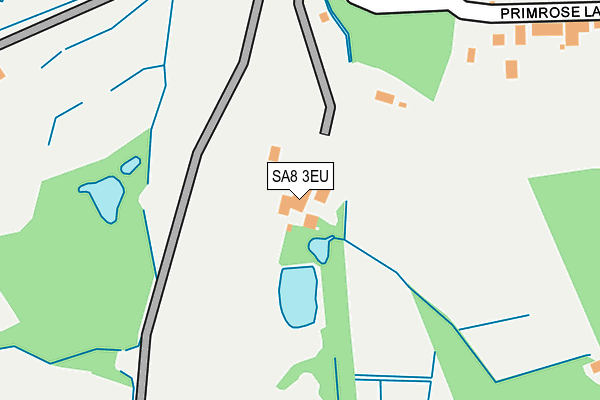
SA8 3EU is located in the Allt-wen electoral ward, within the unitary authority of Neath Port Talbot and the Welsh Parliamentary constituency of Neath. The Local Health Board is Swansea Bay University and the police force is South Wales. This postcode has been in use since January 1980.


GetTheData
Source: OS OpenMap – Local (Ordnance Survey)
Source: OS VectorMap District (Ordnance Survey)
Licence: Open Government Licence (requires attribution)
| Easting | 273545 |
| Northing | 202502 |
| Latitude | 51.706962 |
| Longitude | -3.831503 |
GetTheData
Source: Open Postcode Geo
Licence: Open Government Licence
| Country | Wales |
| Postcode District | SA8 |
➜ See where SA8 is on a map | |
GetTheData
Source: Land Registry Price Paid Data
Licence: Open Government Licence
Elevation or altitude of SA8 3EU as distance above sea level:
| Metres | Feet | |
|---|---|---|
| Elevation | 100m | 328ft |
Elevation is measured from the approximate centre of the postcode, to the nearest point on an OS contour line from OS Terrain 50, which has contour spacing of ten vertical metres.
➜ How high above sea level am I? Find the elevation of your current position using your device's GPS.
GetTheData
Source: Open Postcode Elevation
Licence: Open Government Licence
| Ward | Allt-wen |
| Constituency | Neath |
GetTheData
Source: ONS Postcode Database
Licence: Open Government Licence
| Delffordd South (Delffordd) | Rhos | 348m |
| Primrose Lane (Neath Road) | Rhos | 466m |
| Primrose Lane (Neath Road) | Rhos | 487m |
| Penyralltwen Park (Delffordd) | Rhos | 576m |
| Delffordd | Rhos | 657m |
| Llansamlet Station | 6.3km |
GetTheData
Source: NaPTAN
Licence: Open Government Licence
GetTheData
Source: ONS Postcode Database
Licence: Open Government Licence


➜ Get more ratings from the Food Standards Agency
GetTheData
Source: Food Standards Agency
Licence: FSA terms & conditions
| Last Collection | |||
|---|---|---|---|
| Location | Mon-Fri | Sat | Distance |
| Rhos P O | 17:30 | 11:45 | 601m |
| Ynysmond Road | 17:15 | 08:45 | 1,470m |
| Tesco Pontardawe | 17:45 | 12:30 | 1,681m |
GetTheData
Source: Dracos
Licence: Creative Commons Attribution-ShareAlike
The below table lists the International Territorial Level (ITL) codes (formerly Nomenclature of Territorial Units for Statistics (NUTS) codes) and Local Administrative Units (LAU) codes for SA8 3EU:
| ITL 1 Code | Name |
|---|---|
| TLL | Wales |
| ITL 2 Code | Name |
| TLL1 | West Wales and The Valleys |
| ITL 3 Code | Name |
| TLL17 | Bridgend and Neath Port Talbot |
| LAU 1 Code | Name |
| W06000012 | Neath Port Talbot |
GetTheData
Source: ONS Postcode Directory
Licence: Open Government Licence
The below table lists the Census Output Area (OA), Lower Layer Super Output Area (LSOA), and Middle Layer Super Output Area (MSOA) for SA8 3EU:
| Code | Name | |
|---|---|---|
| OA | W00004732 | |
| LSOA | W01000888 | Neath Port Talbot 004A |
| MSOA | W02000202 | Neath Port Talbot 004 |
GetTheData
Source: ONS Postcode Directory
Licence: Open Government Licence
| SA8 3EN | Delffordd | 295m |
| SA8 3ES | Primrose Lane | 358m |
| SA8 3EJ | Delffordd | 443m |
| SA8 3EW | Delffordd | 451m |
| SA8 3EL | Delffordd | 460m |
| SA8 3EP | Delffordd | 464m |
| SA8 3HS | Waun Daniel | 475m |
| SA8 3HR | Waun Daniel | 480m |
| SA8 3EG | Tirbach Drive | 582m |
| SA8 3ER | Delffordd | 588m |
GetTheData
Source: Open Postcode Geo; Land Registry Price Paid Data
Licence: Open Government Licence