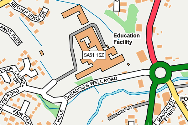
SA61 1SZ is located in the Haverfordwest: Priory electoral ward, within the unitary authority of Pembrokeshire and the Welsh Parliamentary constituency of Preseli Pembrokeshire. The Local Health Board is Hywel Dda University and the police force is Dyfed-Powys. This postcode has been in use since January 1980.


GetTheData
Source: OS OpenMap – Local (Ordnance Survey)
Source: OS VectorMap District (Ordnance Survey)
Licence: Open Government Licence (requires attribution)
| Easting | 194495 |
| Northing | 214611 |
| Latitude | 51.792301 |
| Longitude | -4.981354 |
GetTheData
Source: Open Postcode Geo
Licence: Open Government Licence
| Country | Wales |
| Postcode District | SA61 |
➜ See where SA61 is on a map ➜ Where is Haverfordwest? | |
GetTheData
Source: Land Registry Price Paid Data
Licence: Open Government Licence
Elevation or altitude of SA61 1SZ as distance above sea level:
| Metres | Feet | |
|---|---|---|
| Elevation | 20m | 66ft |
Elevation is measured from the approximate centre of the postcode, to the nearest point on an OS contour line from OS Terrain 50, which has contour spacing of ten vertical metres.
➜ How high above sea level am I? Find the elevation of your current position using your device's GPS.
GetTheData
Source: Open Postcode Elevation
Licence: Open Government Licence
| Ward | Haverfordwest: Priory |
| Constituency | Preseli Pembrokeshire |
GetTheData
Source: ONS Postcode Database
Licence: Open Government Licence
| Pembrokeshire College (Grounds) | Merlin's Bridge | 55m |
| Glen Hotel (Merlin`s Hill) | Merlin's Bridge | 178m |
| Merlin's Bridge Boxing Club (A4076) | Merlin's Bridge | 232m |
| Merlin's Bridge Post Office (Magdalen Street) | Merlin's Bridge | 271m |
| Merlin's Bridge War Memorial (A4076) | Merlin's Bridge | 284m |
| Haverfordwest Station | 1.9km |
| Johnston (Pembrokeshire) Station | 4.1km |
GetTheData
Source: NaPTAN
Licence: Open Government Licence
GetTheData
Source: ONS Postcode Database
Licence: Open Government Licence


➜ Get more ratings from the Food Standards Agency
GetTheData
Source: Food Standards Agency
Licence: FSA terms & conditions
| Last Collection | |||
|---|---|---|---|
| Location | Mon-Fri | Sat | Distance |
| Haverfordwest Delivery Office | 18:00 | 13:00 | 159m |
| Old Hakin Road | 17:30 | 12:15 | 269m |
| Merlins Bridge P O | 17:15 | 12:15 | 287m |
GetTheData
Source: Dracos
Licence: Creative Commons Attribution-ShareAlike
The below table lists the International Territorial Level (ITL) codes (formerly Nomenclature of Territorial Units for Statistics (NUTS) codes) and Local Administrative Units (LAU) codes for SA61 1SZ:
| ITL 1 Code | Name |
|---|---|
| TLL | Wales |
| ITL 2 Code | Name |
| TLL1 | West Wales and The Valleys |
| ITL 3 Code | Name |
| TLL14 | South West Wales |
| LAU 1 Code | Name |
| W06000009 | Pembrokeshire |
GetTheData
Source: ONS Postcode Directory
Licence: Open Government Licence
The below table lists the Census Output Area (OA), Lower Layer Super Output Area (LSOA), and Middle Layer Super Output Area (MSOA) for SA61 1SZ:
| Code | Name | |
|---|---|---|
| OA | W00003063 | |
| LSOA | W01000573 | Pembrokeshire 006B |
| MSOA | W02000131 | Pembrokeshire 006 |
GetTheData
Source: ONS Postcode Directory
Licence: Open Government Licence
| SA61 1XB | Mill Lane | 179m |
| SA61 1EN | Beechlands Park | 203m |
| SA61 1ED | Nether Edge Drive | 249m |
| SA61 1XD | Glen View | 251m |
| SA61 1EE | Fair Oakes | 270m |
| SA61 1EP | Scarrowscant Lane | 271m |
| SA61 1EW | Brooklands Park | 274m |
| SA61 1EL | St Anthonys Way | 275m |
| SA61 1JJ | Magdelene Street | 289m |
| SA61 1XA | Merlins Hill | 293m |
GetTheData
Source: Open Postcode Geo; Land Registry Price Paid Data
Licence: Open Government Licence