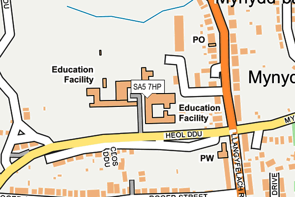
SA5 7HP is located in the Mynydd-bach electoral ward, within the unitary authority of Swansea and the Welsh Parliamentary constituency of Swansea East. The Local Health Board is Swansea Bay University and the police force is South Wales. This postcode has been in use since January 1980.


GetTheData
Source: OS OpenMap – Local (Ordnance Survey)
Source: OS VectorMap District (Ordnance Survey)
Licence: Open Government Licence (requires attribution)
| Easting | 265057 |
| Northing | 197427 |
| Latitude | 51.659380 |
| Longitude | -3.952306 |
GetTheData
Source: Open Postcode Geo
Licence: Open Government Licence
| Country | Wales |
| Postcode District | SA5 |
➜ See where SA5 is on a map ➜ Where is Swansea? | |
GetTheData
Source: Land Registry Price Paid Data
Licence: Open Government Licence
Elevation or altitude of SA5 7HP as distance above sea level:
| Metres | Feet | |
|---|---|---|
| Elevation | 150m | 492ft |
Elevation is measured from the approximate centre of the postcode, to the nearest point on an OS contour line from OS Terrain 50, which has contour spacing of ten vertical metres.
➜ How high above sea level am I? Find the elevation of your current position using your device's GPS.
GetTheData
Source: Open Postcode Elevation
Licence: Open Government Licence
| Ward | Mynydd-bach |
| Constituency | Swansea East |
GetTheData
Source: ONS Postcode Database
Licence: Open Government Licence
| Mynyddbach Comprehensive (Heol Ddu) | Tirdeunaw | 75m |
| Caersalem Cross (Llangyfelach Road) | Mynydd-bach | 158m |
| Caersalem Cross (Llangyfelach Road) | Tirdeunaw | 207m |
| Caersalem Cross (Mynydd Garnllwyd Road) | Tirdeunaw | 218m |
| Welcome Inn (Llangyfelach Road) | Mynydd-bach | 299m |
| Swansea Station | 3.9km |
| Llansamlet Station | 4.7km |
GetTheData
Source: NaPTAN
Licence: Open Government Licence
GetTheData
Source: ONS Postcode Database
Licence: Open Government Licence


➜ Get more ratings from the Food Standards Agency
GetTheData
Source: Food Standards Agency
Licence: FSA terms & conditions
| Last Collection | |||
|---|---|---|---|
| Location | Mon-Fri | Sat | Distance |
| Mynydd Garnlwydd Road | 18:15 | 13:15 | 473m |
| Llangyfelach P.o. | 18:00 | 11:00 | 1,554m |
| Yetwen | 18:30 | 13:00 | 1,671m |
GetTheData
Source: Dracos
Licence: Creative Commons Attribution-ShareAlike
The below table lists the International Territorial Level (ITL) codes (formerly Nomenclature of Territorial Units for Statistics (NUTS) codes) and Local Administrative Units (LAU) codes for SA5 7HP:
| ITL 1 Code | Name |
|---|---|
| TLL | Wales |
| ITL 2 Code | Name |
| TLL1 | West Wales and The Valleys |
| ITL 3 Code | Name |
| TLL18 | Swansea |
| LAU 1 Code | Name |
| W06000011 | Swansea |
GetTheData
Source: ONS Postcode Directory
Licence: Open Government Licence
The below table lists the Census Output Area (OA), Lower Layer Super Output Area (LSOA), and Middle Layer Super Output Area (MSOA) for SA5 7HP:
| Code | Name | |
|---|---|---|
| OA | W00004384 | |
| LSOA | W01000818 | Swansea 009B |
| MSOA | W02000176 | Swansea 009 |
GetTheData
Source: ONS Postcode Directory
Licence: Open Government Licence
| SA5 9BD | St Judes Close | 169m |
| SA5 7HR | Llangyfelach Road | 181m |
| SA5 7HW | Heol Ddu | 186m |
| SA5 9AS | Roger Street | 193m |
| SA6 7PF | Clos Caersalem | 252m |
| SA5 7HS | Llangyfelach Road | 259m |
| SA5 9AU | Llangyfelach Road | 262m |
| SA5 9AT | Plover Close | 268m |
| SA5 9AR | Roger Street | 288m |
| SA5 9AY | Knoyle Street | 296m |
GetTheData
Source: Open Postcode Geo; Land Registry Price Paid Data
Licence: Open Government Licence