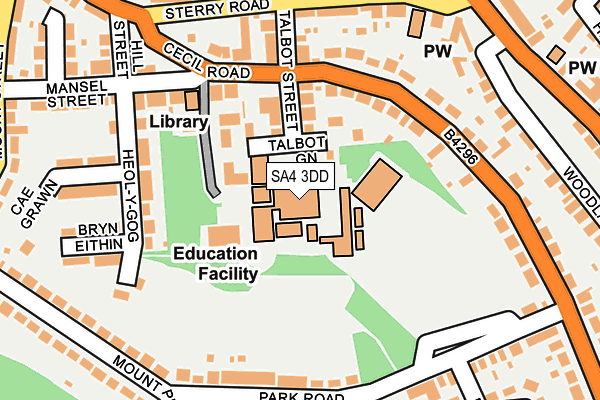
SA4 3DD is located in the Gowerton electoral ward, within the unitary authority of Swansea and the Welsh Parliamentary constituency of Gower. The Local Health Board is Swansea Bay University and the police force is South Wales. This postcode has been in use since January 1980.


GetTheData
Source: OS OpenMap – Local (Ordnance Survey)
Source: OS VectorMap District (Ordnance Survey)
Licence: Open Government Licence (requires attribution)
| Easting | 259007 |
| Northing | 196092 |
| Latitude | 51.645898 |
| Longitude | -4.039176 |
GetTheData
Source: Open Postcode Geo
Licence: Open Government Licence
| Country | Wales |
| Postcode District | SA4 |
➜ See where SA4 is on a map ➜ Where is Gowerton? | |
GetTheData
Source: Land Registry Price Paid Data
Licence: Open Government Licence
Elevation or altitude of SA4 3DD as distance above sea level:
| Metres | Feet | |
|---|---|---|
| Elevation | 30m | 98ft |
Elevation is measured from the approximate centre of the postcode, to the nearest point on an OS contour line from OS Terrain 50, which has contour spacing of ten vertical metres.
➜ How high above sea level am I? Find the elevation of your current position using your device's GPS.
GetTheData
Source: Open Postcode Elevation
Licence: Open Government Licence
| Ward | Gowerton |
| Constituency | Gower |
GetTheData
Source: ONS Postcode Database
Licence: Open Government Licence
| Woodlands (Cecil Road) | Gowerton | 157m |
| Cecil Road | Gowerton | 168m |
| Comprehensive School (Park Road) | Gowerton | 201m |
| Post Office (Sterry Road) | Gowerton | 211m |
| Park Road | Gowerton | 225m |
| Gowerton Station | 0.4km |
| Bynea Station | 5.1km |
GetTheData
Source: NaPTAN
Licence: Open Government Licence
GetTheData
Source: ONS Postcode Database
Licence: Open Government Licence


➜ Get more ratings from the Food Standards Agency
GetTheData
Source: Food Standards Agency
Licence: FSA terms & conditions
| Last Collection | |||
|---|---|---|---|
| Location | Mon-Fri | Sat | Distance |
| Mount Pleasant | 17:45 | 13:15 | 224m |
| Gowerton P O | 17:45 | 11:30 | 247m |
| Cecil Road | 17:45 | 11:15 | 287m |
GetTheData
Source: Dracos
Licence: Creative Commons Attribution-ShareAlike
The below table lists the International Territorial Level (ITL) codes (formerly Nomenclature of Territorial Units for Statistics (NUTS) codes) and Local Administrative Units (LAU) codes for SA4 3DD:
| ITL 1 Code | Name |
|---|---|
| TLL | Wales |
| ITL 2 Code | Name |
| TLL1 | West Wales and The Valleys |
| ITL 3 Code | Name |
| TLL18 | Swansea |
| LAU 1 Code | Name |
| W06000011 | Swansea |
GetTheData
Source: ONS Postcode Directory
Licence: Open Government Licence
The below table lists the Census Output Area (OA), Lower Layer Super Output Area (LSOA), and Middle Layer Super Output Area (MSOA) for SA4 3DD:
| Code | Name | |
|---|---|---|
| OA | W00004179 | |
| LSOA | W01000779 | Swansea 012D |
| MSOA | W02000179 | Swansea 012 |
GetTheData
Source: ONS Postcode Directory
Licence: Open Government Licence
| SA4 3DH | Talbot Green | 89m |
| SA4 3DB | Talbot Street | 139m |
| SA4 3DE | Cecil Road | 147m |
| SA4 3BX | Heol Y Gog | 157m |
| SA4 3DA | Cecil Road | 165m |
| SA4 3EP | Park Road | 182m |
| SA4 3DF | Cecil Road | 186m |
| SA4 3BU | Mansel Street | 197m |
| SA4 3BW | Sterry Road | 205m |
| SA4 3BY | Cae Grawn | 208m |
GetTheData
Source: Open Postcode Geo; Land Registry Price Paid Data
Licence: Open Government Licence