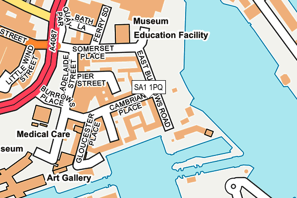
SA1 1PQ is located in the Waterfront electoral ward, within the unitary authority of Swansea and the Welsh Parliamentary constituency of Swansea West. The Local Health Board is Swansea Bay University and the police force is South Wales. This postcode has been in use since October 1984.


GetTheData
Source: OS OpenMap – Local (Ordnance Survey)
Source: OS VectorMap District (Ordnance Survey)
Licence: Open Government Licence (requires attribution)
| Easting | 266133 |
| Northing | 192799 |
| Latitude | 51.618049 |
| Longitude | -3.934988 |
GetTheData
Source: Open Postcode Geo
Licence: Open Government Licence
| Country | Wales |
| Postcode District | SA1 |
➜ See where SA1 is on a map | |
GetTheData
Source: Land Registry Price Paid Data
Licence: Open Government Licence
Elevation or altitude of SA1 1PQ as distance above sea level:
| Metres | Feet | |
|---|---|---|
| Elevation | 10m | 33ft |
Elevation is measured from the approximate centre of the postcode, to the nearest point on an OS contour line from OS Terrain 50, which has contour spacing of ten vertical metres.
➜ How high above sea level am I? Find the elevation of your current position using your device's GPS.
GetTheData
Source: Open Postcode Elevation
Licence: Open Government Licence
| Ward | Waterfront |
| Constituency | Swansea West |
GetTheData
Source: ONS Postcode Database
Licence: Open Government Licence
| Environment Centre (Somerset Place) | Swansea | 122m |
| Swansea Marina (Trawler Road) | Pentre Guinea | 270m |
| Sainsbury's (Quay Parade) | Swansea | 276m |
| Sainsbury's (Quay Parade) | St Thomas | 295m |
| Wind Street | Swansea | 324m |
| Swansea Station | 0.9km |
| Llansamlet Station | 6km |
GetTheData
Source: NaPTAN
Licence: Open Government Licence
GetTheData
Source: ONS Postcode Database
Licence: Open Government Licence


➜ Get more ratings from the Food Standards Agency
GetTheData
Source: Food Standards Agency
Licence: FSA terms & conditions
| Last Collection | |||
|---|---|---|---|
| Location | Mon-Fri | Sat | Distance |
| Cambrian Place | 18:15 | 10:30 | 134m |
| Ferrara Quay | 18:00 | 10:15 | 316m |
| St. Marys Sq | 17:30 | 10:30 | 632m |
GetTheData
Source: Dracos
Licence: Creative Commons Attribution-ShareAlike
The below table lists the International Territorial Level (ITL) codes (formerly Nomenclature of Territorial Units for Statistics (NUTS) codes) and Local Administrative Units (LAU) codes for SA1 1PQ:
| ITL 1 Code | Name |
|---|---|
| TLL | Wales |
| ITL 2 Code | Name |
| TLL1 | West Wales and The Valleys |
| ITL 3 Code | Name |
| TLL18 | Swansea |
| LAU 1 Code | Name |
| W06000011 | Swansea |
GetTheData
Source: ONS Postcode Directory
Licence: Open Government Licence
The below table lists the Census Output Area (OA), Lower Layer Super Output Area (LSOA), and Middle Layer Super Output Area (MSOA) for SA1 1PQ:
| Code | Name | |
|---|---|---|
| OA | W00003990 | |
| LSOA | W01001938 | Swansea 025E |
| MSOA | W02000192 | Swansea 025 |
GetTheData
Source: ONS Postcode Directory
Licence: Open Government Licence
| SA1 1RG | Cambrian Place | 33m |
| SA1 1RE | East Burrows Road | 50m |
| SA1 1RT | Mannheim Quay | 53m |
| SA1 1RQ | Cambrian Place | 63m |
| SA1 1WD | Mannheim Quay | 64m |
| SA1 1RL | Cambrian Place | 81m |
| SA1 1RU | Mannheim Quay | 89m |
| SA1 1RY | Pier Street | 94m |
| SA1 1RH | Cambrian Place | 99m |
| SA1 1RR | Somerset Place | 106m |
GetTheData
Source: Open Postcode Geo; Land Registry Price Paid Data
Licence: Open Government Licence