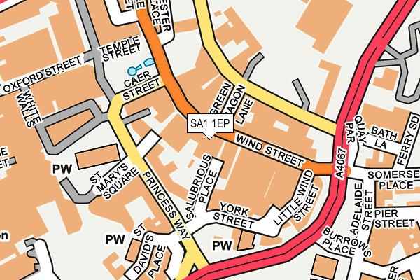
SA1 1EP is located in the Castle electoral ward, within the unitary authority of Swansea and the Welsh Parliamentary constituency of Swansea West. The Local Health Board is Swansea Bay University and the police force is South Wales. This postcode has been in use since January 1980.


GetTheData
Source: OS OpenMap – Local (Ordnance Survey)
Source: OS VectorMap District (Ordnance Survey)
Licence: Open Government Licence (requires attribution)
| Easting | 265754 |
| Northing | 192950 |
| Latitude | 51.619316 |
| Longitude | -3.940517 |
GetTheData
Source: Open Postcode Geo
Licence: Open Government Licence
| Country | Wales |
| Postcode District | SA1 |
➜ See where SA1 is on a map ➜ Where is Swansea? | |
GetTheData
Source: Land Registry Price Paid Data
Licence: Open Government Licence
Elevation or altitude of SA1 1EP as distance above sea level:
| Metres | Feet | |
|---|---|---|
| Elevation | 10m | 33ft |
Elevation is measured from the approximate centre of the postcode, to the nearest point on an OS contour line from OS Terrain 50, which has contour spacing of ten vertical metres.
➜ How high above sea level am I? Find the elevation of your current position using your device's GPS.
GetTheData
Source: Open Postcode Elevation
Licence: Open Government Licence
| Ward | Castle |
| Constituency | Swansea West |
GetTheData
Source: ONS Postcode Database
Licence: Open Government Licence
| Wind Street | Swansea | 61m |
| Wind Street | Swansea | 86m |
| Castle Square C (Caer Street) | Swansea | 122m |
| St Mary`s Church (Princess Way) | Swansea | 124m |
| St Mary's Church (Princess Way) | Swansea | 128m |
| Swansea Station | 0.7km |
| Llansamlet Station | 6.1km |
GetTheData
Source: NaPTAN
Licence: Open Government Licence
GetTheData
Source: ONS Postcode Database
Licence: Open Government Licence


➜ Get more ratings from the Food Standards Agency
GetTheData
Source: Food Standards Agency
Licence: FSA terms & conditions
| Last Collection | |||
|---|---|---|---|
| Location | Mon-Fri | Sat | Distance |
| St. Marys Sq | 17:30 | 10:30 | 237m |
| Cambrian Place | 18:15 | 10:30 | 306m |
| Union St Business Box | 18:45 | 387m | |
GetTheData
Source: Dracos
Licence: Creative Commons Attribution-ShareAlike
The below table lists the International Territorial Level (ITL) codes (formerly Nomenclature of Territorial Units for Statistics (NUTS) codes) and Local Administrative Units (LAU) codes for SA1 1EP:
| ITL 1 Code | Name |
|---|---|
| TLL | Wales |
| ITL 2 Code | Name |
| TLL1 | West Wales and The Valleys |
| ITL 3 Code | Name |
| TLL18 | Swansea |
| LAU 1 Code | Name |
| W06000011 | Swansea |
GetTheData
Source: ONS Postcode Directory
Licence: Open Government Licence
The below table lists the Census Output Area (OA), Lower Layer Super Output Area (LSOA), and Middle Layer Super Output Area (MSOA) for SA1 1EP:
| Code | Name | |
|---|---|---|
| OA | W00010090 | |
| LSOA | W01001955 | Swansea 025F |
| MSOA | W02000192 | Swansea 025 |
GetTheData
Source: ONS Postcode Directory
Licence: Open Government Licence
| SA1 1EQ | Wind Street | 44m |
| SA1 1DE | Wind Street | 54m |
| SA1 3RT | Salubrious Passage | 54m |
| SA1 1DG | Green Dragon Lane | 58m |
| SA1 3LH | St Mary Street | 78m |
| SA1 1EF | Wind Street | 85m |
| SA1 3LW | Princess Way | 87m |
| SA1 1DP | Wind Street | 95m |
| SA1 1DZ | Wind Street | 117m |
| SA1 3LQ | Princess Way | 146m |
GetTheData
Source: Open Postcode Geo; Land Registry Price Paid Data
Licence: Open Government Licence