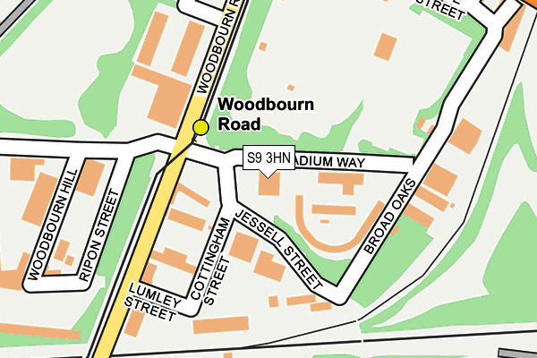
S9 3HN is located in the Darnall electoral ward, within the metropolitan district of Sheffield and the English Parliamentary constituency of Sheffield South East. The Sub Integrated Care Board (ICB) Location is NHS South Yorkshire ICB - 03N and the police force is South Yorkshire. This postcode has been in use since November 2008.


GetTheData
Source: OS OpenMap – Local (Ordnance Survey)
Source: OS VectorMap District (Ordnance Survey)
Licence: Open Government Licence (requires attribution)
| Easting | 437763 |
| Northing | 388070 |
| Latitude | 53.388145 |
| Longitude | -1.433673 |
GetTheData
Source: Open Postcode Geo
Licence: Open Government Licence
| Country | England |
| Postcode District | S9 |
➜ See where S9 is on a map ➜ Where is Sheffield? | |
GetTheData
Source: Land Registry Price Paid Data
Licence: Open Government Licence
Elevation or altitude of S9 3HN as distance above sea level:
| Metres | Feet | |
|---|---|---|
| Elevation | 60m | 197ft |
Elevation is measured from the approximate centre of the postcode, to the nearest point on an OS contour line from OS Terrain 50, which has contour spacing of ten vertical metres.
➜ How high above sea level am I? Find the elevation of your current position using your device's GPS.
GetTheData
Source: Open Postcode Elevation
Licence: Open Government Licence
| Ward | Darnall |
| Constituency | Sheffield South East |
GetTheData
Source: ONS Postcode Database
Licence: Open Government Licence
| Woodbourn Road (Parkway Avenue) | Parkway Industrial Estate | 299m |
| Woodbourn Road (Staniforth Road) | Attercliffe | 310m |
| Woodbourn Road (Parkway Avenue) | Parkway Industrial Estate | 322m |
| Palmer Street (Staniforth Road) | Attercliffe | 328m |
| Ouse Road (Staniforth Road) | Attercliffe | 377m |
| Woodbourn Road (Sheffield Supertram) (Woodbourn Road) | Attercliffe | 99m |
| Attercliffe (Sheffield Supertram) (Shortridge Street) | Attercliffe | 525m |
| Nunnery Square (Sheffield Supertram) (Nunnery Square) | Attercliffe | 612m |
| Cricket Inn Road (Sheffield Supertram) (Cricket Inn Road) | Park Hill | 976m |
| Hyde Park (Sheffield Supertram) (Cricket Inn Road) | Hyde Park | 1,306m |
| Darnall Station | 1.5km |
| Sheffield Station | 2.2km |
| Meadowhall Station | 3.5km |
GetTheData
Source: NaPTAN
Licence: Open Government Licence
GetTheData
Source: ONS Postcode Database
Licence: Open Government Licence


➜ Get more ratings from the Food Standards Agency
GetTheData
Source: Food Standards Agency
Licence: FSA terms & conditions
| Last Collection | |||
|---|---|---|---|
| Location | Mon-Fri | Sat | Distance |
| Parkway Avenue | 18:30 | 326m | |
| Shortridge Street | 17:45 | 10:30 | 518m |
| Washford Road | 17:30 | 10:30 | 556m |
GetTheData
Source: Dracos
Licence: Creative Commons Attribution-ShareAlike
The below table lists the International Territorial Level (ITL) codes (formerly Nomenclature of Territorial Units for Statistics (NUTS) codes) and Local Administrative Units (LAU) codes for S9 3HN:
| ITL 1 Code | Name |
|---|---|
| TLE | Yorkshire and The Humber |
| ITL 2 Code | Name |
| TLE3 | South Yorkshire |
| ITL 3 Code | Name |
| TLE32 | Sheffield |
| LAU 1 Code | Name |
| E08000019 | Sheffield |
GetTheData
Source: ONS Postcode Directory
Licence: Open Government Licence
The below table lists the Census Output Area (OA), Lower Layer Super Output Area (LSOA), and Middle Layer Super Output Area (MSOA) for S9 3HN:
| Code | Name | |
|---|---|---|
| OA | E00039898 | |
| LSOA | E01007883 | Sheffield 027A |
| MSOA | E02001637 | Sheffield 027 |
GetTheData
Source: ONS Postcode Directory
Licence: Open Government Licence
| S9 4WA | Parkway Avenue | 332m |
| S9 3HF | Staniforth Road | 334m |
| S9 3AD | Ouse Road | 425m |
| S9 3HB | Staniforth Road | 428m |
| S9 3FS | Staniforth Road | 429m |
| S9 3QP | Attercliffe Road | 446m |
| S9 3AA | Ouseburn Street | 449m |
| S9 4WD | Parkway Avenue | 471m |
| S9 3QH | Stoke Street | 478m |
| S9 3BB | Nidd Road | 486m |
GetTheData
Source: Open Postcode Geo; Land Registry Price Paid Data
Licence: Open Government Licence