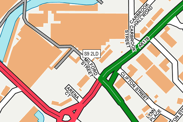
S9 2LD lies on Milford Street in Sheffield. S9 2LD is located in the Darnall electoral ward, within the metropolitan district of Sheffield and the English Parliamentary constituency of Sheffield South East. The Sub Integrated Care Board (ICB) Location is NHS South Yorkshire ICB - 03N and the police force is South Yorkshire. This postcode has been in use since January 1980.


GetTheData
Source: OS OpenMap – Local (Ordnance Survey)
Source: OS VectorMap District (Ordnance Survey)
Licence: Open Government Licence (requires attribution)
| Easting | 438628 |
| Northing | 389808 |
| Latitude | 53.403704 |
| Longitude | -1.420456 |
GetTheData
Source: Open Postcode Geo
Licence: Open Government Licence
| Street | Milford Street |
| Town/City | Sheffield |
| Country | England |
| Postcode District | S9 |
➜ See where S9 is on a map ➜ Where is Sheffield? | |
GetTheData
Source: Land Registry Price Paid Data
Licence: Open Government Licence
Elevation or altitude of S9 2LD as distance above sea level:
| Metres | Feet | |
|---|---|---|
| Elevation | 40m | 131ft |
Elevation is measured from the approximate centre of the postcode, to the nearest point on an OS contour line from OS Terrain 50, which has contour spacing of ten vertical metres.
➜ How high above sea level am I? Find the elevation of your current position using your device's GPS.
GetTheData
Source: Open Postcode Elevation
Licence: Open Government Licence
| Ward | Darnall |
| Constituency | Sheffield South East |
GetTheData
Source: ONS Postcode Database
Licence: Open Government Licence
32, MILFORD STREET, SHEFFIELD, S9 2LD 1998 9 JAN £17,500 |
GetTheData
Source: HM Land Registry Price Paid Data
Licence: Contains HM Land Registry data © Crown copyright and database right 2025. This data is licensed under the Open Government Licence v3.0.
| Arena Square (Attercliffe Common) | Carbrook | 121m |
| Arena Square (Attercliffe Common) | Carbrook | 125m |
| Carbrook Street (Attercliffe Common) | Carbrook | 267m |
| Meadowhall Retail Park (Attercliffe Common) | Carbrook | 333m |
| Amberley Street (Attercliffe Common) | Carbrook | 384m |
| Valley Centertainment (Sheffield Supertram) (Off Greenland Road) | Carbrook | 544m |
| Arena - Don Valley (Sheffield Supertram) (Off Coleridge Road) | Don Valley | 611m |
| Carbrook (Sheffield Supertram) (Off Sheffield Road - Attercliffe Road) | Carbrook | 671m |
| Attercliffe (Sheffield Supertram) (Shortridge Street) | Attercliffe | 1,416m |
| Meadowhall South - Tinsley (Sheffield Supertram) (Off Meadowhall Way) | Meadowhall | 1,560m |
| Meadowhall Station | 1.6km |
| Darnall Station | 2.2km |
| Sheffield Station | 4km |
GetTheData
Source: NaPTAN
Licence: Open Government Licence
GetTheData
Source: ONS Postcode Database
Licence: Open Government Licence


➜ Get more ratings from the Food Standards Agency
GetTheData
Source: Food Standards Agency
Licence: FSA terms & conditions
| Last Collection | |||
|---|---|---|---|
| Location | Mon-Fri | Sat | Distance |
| Coleridge Road | 17:30 | 10:30 | 548m |
| Lockhouse Road | 18:30 | 09:00 | 627m |
| Lockhouse Road | 18:30 | 629m | |
GetTheData
Source: Dracos
Licence: Creative Commons Attribution-ShareAlike
The below table lists the International Territorial Level (ITL) codes (formerly Nomenclature of Territorial Units for Statistics (NUTS) codes) and Local Administrative Units (LAU) codes for S9 2LD:
| ITL 1 Code | Name |
|---|---|
| TLE | Yorkshire and The Humber |
| ITL 2 Code | Name |
| TLE3 | South Yorkshire |
| ITL 3 Code | Name |
| TLE32 | Sheffield |
| LAU 1 Code | Name |
| E08000019 | Sheffield |
GetTheData
Source: ONS Postcode Directory
Licence: Open Government Licence
The below table lists the Census Output Area (OA), Lower Layer Super Output Area (LSOA), and Middle Layer Super Output Area (MSOA) for S9 2LD:
| Code | Name | |
|---|---|---|
| OA | E00040045 | |
| LSOA | E01007904 | Sheffield 018B |
| MSOA | E02001628 | Sheffield 018 |
GetTheData
Source: ONS Postcode Directory
Licence: Open Government Licence
| S9 2BT | Attercliffe Common | 121m |
| S9 2DQ | Clifton Street | 205m |
| S9 2LR | Bold Street | 439m |
| S9 2DF | Broughton Lane | 448m |
| S9 2RX | Brightside Lane | 453m |
| S9 2LQ | Amberley Court | 484m |
| S9 2EP | Valley Centertainment | 502m |
| S9 2PR | Leigh Street | 713m |
| S9 2FY | Sheffield Road | 724m |
| S9 2AE | Attercliffe Common | 749m |
GetTheData
Source: Open Postcode Geo; Land Registry Price Paid Data
Licence: Open Government Licence