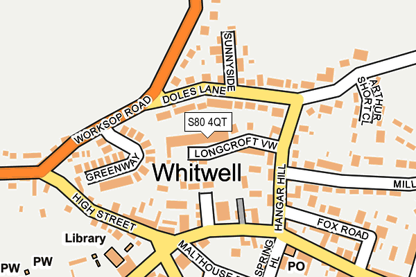
S80 4QT lies on Longcroft View in Whitwell, Worksop. S80 4QT is located in the Whitwell electoral ward, within the local authority district of Bolsover and the English Parliamentary constituency of Bolsover. The Sub Integrated Care Board (ICB) Location is NHS Derby and Derbyshire ICB - 15M and the police force is Derbyshire. This postcode has been in use since January 1980.


GetTheData
Source: OS OpenMap – Local (Ordnance Survey)
Source: OS VectorMap District (Ordnance Survey)
Licence: Open Government Licence (requires attribution)
| Easting | 453044 |
| Northing | 376838 |
| Latitude | 53.285866 |
| Longitude | -1.205812 |
GetTheData
Source: Open Postcode Geo
Licence: Open Government Licence
| Street | Longcroft View |
| Locality | Whitwell |
| Town/City | Worksop |
| Country | England |
| Postcode District | S80 |
➜ See where S80 is on a map ➜ Where is Whitwell? | |
GetTheData
Source: Land Registry Price Paid Data
Licence: Open Government Licence
Elevation or altitude of S80 4QT as distance above sea level:
| Metres | Feet | |
|---|---|---|
| Elevation | 110m | 361ft |
Elevation is measured from the approximate centre of the postcode, to the nearest point on an OS contour line from OS Terrain 50, which has contour spacing of ten vertical metres.
➜ How high above sea level am I? Find the elevation of your current position using your device's GPS.
GetTheData
Source: Open Postcode Elevation
Licence: Open Government Licence
| Ward | Whitwell |
| Constituency | Bolsover |
GetTheData
Source: ONS Postcode Database
Licence: Open Government Licence
6B, LONGCROFT VIEW, WHITWELL, WORKSOP, S80 4QT 2024 4 OCT £275,000 |
6D, LONGCROFT VIEW, WHITWELL, WORKSOP, S80 4QT 2002 7 JAN £127,800 |
6A, LONGCROFT VIEW, WHITWELL, WORKSOP, S80 4QT 1997 23 MAY £55,000 |
GetTheData
Source: HM Land Registry Price Paid Data
Licence: Contains HM Land Registry data © Crown copyright and database right 2025. This data is licensed under the Open Government Licence v3.0.
| Co-op (Hangar Hill) | Whitwell | 147m |
| Square (High Street) | Whitwell | 156m |
| Square (High Street) | Whitwell | 167m |
| Square (Portland Street) | Whitwell | 191m |
| Co-op (Welbeck Street) | Whitwell | 195m |
| Whitwell (Derbys) Station | 0.8km |
| Creswell (Derbys) Station | 2.5km |
| Shireoaks Station | 5km |
GetTheData
Source: NaPTAN
Licence: Open Government Licence
| Percentage of properties with Next Generation Access | 100.0% |
| Percentage of properties with Superfast Broadband | 100.0% |
| Percentage of properties with Ultrafast Broadband | 5.0% |
| Percentage of properties with Full Fibre Broadband | 0.0% |
Superfast Broadband is between 30Mbps and 300Mbps
Ultrafast Broadband is > 300Mbps
| Median download speed | 40.0Mbps |
| Average download speed | 44.2Mbps |
| Maximum download speed | 79.84Mbps |
| Median upload speed | 10.0Mbps |
| Average upload speed | 11.8Mbps |
| Maximum upload speed | 20.00Mbps |
| Percentage of properties unable to receive 2Mbps | 0.0% |
| Percentage of properties unable to receive 5Mbps | 0.0% |
| Percentage of properties unable to receive 10Mbps | 0.0% |
| Percentage of properties unable to receive 30Mbps | 0.0% |
GetTheData
Source: Ofcom
Licence: Ofcom Terms of Use (requires attribution)
Estimated total energy consumption in S80 4QT by fuel type, 2015.
| Consumption (kWh) | 246,002 |
|---|---|
| Meter count | 20 |
| Mean (kWh/meter) | 12,300 |
| Median (kWh/meter) | 11,163 |
| Consumption (kWh) | 72,755 |
|---|---|
| Meter count | 20 |
| Mean (kWh/meter) | 3,638 |
| Median (kWh/meter) | 2,805 |
GetTheData
Source: Postcode level gas estimates: 2015 (experimental)
Source: Postcode level electricity estimates: 2015 (experimental)
Licence: Open Government Licence
GetTheData
Source: ONS Postcode Database
Licence: Open Government Licence


➜ Get more ratings from the Food Standards Agency
GetTheData
Source: Food Standards Agency
Licence: FSA terms & conditions
| Last Collection | |||
|---|---|---|---|
| Location | Mon-Fri | Sat | Distance |
| Station Road | 16:00 | 10:30 | 191m |
| Welbeck Street | 16:00 | 10:30 | 365m |
| 15 Southfield Lane | 16:00 | 10:30 | 424m |
GetTheData
Source: Dracos
Licence: Creative Commons Attribution-ShareAlike
The below table lists the International Territorial Level (ITL) codes (formerly Nomenclature of Territorial Units for Statistics (NUTS) codes) and Local Administrative Units (LAU) codes for S80 4QT:
| ITL 1 Code | Name |
|---|---|
| TLF | East Midlands (England) |
| ITL 2 Code | Name |
| TLF1 | Derbyshire and Nottinghamshire |
| ITL 3 Code | Name |
| TLF12 | East Derbyshire |
| LAU 1 Code | Name |
| E07000033 | Bolsover |
GetTheData
Source: ONS Postcode Directory
Licence: Open Government Licence
The below table lists the Census Output Area (OA), Lower Layer Super Output Area (LSOA), and Middle Layer Super Output Area (MSOA) for S80 4QT:
| Code | Name | |
|---|---|---|
| OA | E00098748 | |
| LSOA | E01019524 | Bolsover 002C |
| MSOA | E02004046 | Bolsover 002 |
GetTheData
Source: ONS Postcode Directory
Licence: Open Government Licence
| S80 4SW | Doles Lane | 57m |
| S80 4SS | Doles Lane | 89m |
| S80 4GN | Old Green Close | 99m |
| S80 4SD | Hangar Hill | 105m |
| S80 4GL | Old Green Close | 107m |
| S80 4SP | Sunnyside | 127m |
| S80 4SY | The Greenway | 138m |
| S80 4SR | Sunnyside | 143m |
| S80 4SN | Doles Lane | 147m |
| S80 4ST | Worksop Road | 156m |
GetTheData
Source: Open Postcode Geo; Land Registry Price Paid Data
Licence: Open Government Licence