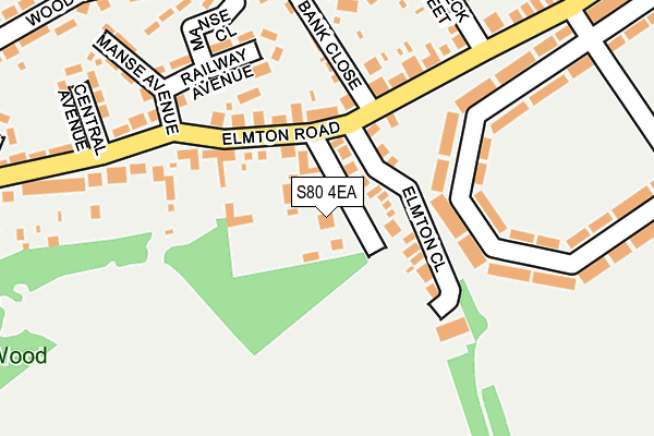
S80 4EA is located in the Elmton-with-Creswell electoral ward, within the local authority district of Bolsover and the English Parliamentary constituency of Bolsover. The Sub Integrated Care Board (ICB) Location is NHS Derby and Derbyshire ICB - 15M and the police force is Derbyshire. This postcode has been in use since January 1980.


GetTheData
Source: OS OpenMap – Local (Ordnance Survey)
Source: OS VectorMap District (Ordnance Survey)
Licence: Open Government Licence (requires attribution)
| Easting | 451810 |
| Northing | 373832 |
| Latitude | 53.258991 |
| Longitude | -1.224807 |
GetTheData
Source: Open Postcode Geo
Licence: Open Government Licence
| Country | England |
| Postcode District | S80 |
➜ See where S80 is on a map ➜ Where is Creswell? | |
GetTheData
Source: Land Registry Price Paid Data
Licence: Open Government Licence
Elevation or altitude of S80 4EA as distance above sea level:
| Metres | Feet | |
|---|---|---|
| Elevation | 100m | 328ft |
Elevation is measured from the approximate centre of the postcode, to the nearest point on an OS contour line from OS Terrain 50, which has contour spacing of ten vertical metres.
➜ How high above sea level am I? Find the elevation of your current position using your device's GPS.
GetTheData
Source: Open Postcode Elevation
Licence: Open Government Licence
| Ward | Elmton-with-creswell |
| Constituency | Bolsover |
GetTheData
Source: ONS Postcode Database
Licence: Open Government Licence
| Manse Avenue (Elmton Road) | Creswell | 155m |
| Holbeck Street (Elmton Road) | Creswell | 176m |
| Portland Avenue (Holbeck Street) | Creswell | 232m |
| Sherwood Avenue (West Street) | Creswell | 237m |
| Portland Avenue (Holbeck Street) | Creswell | 258m |
| Creswell (Derbys) Station | 0.8km |
| Whitwell (Derbys) Station | 2.9km |
| Langwith - Whaley Thorns Station | 3.2km |
GetTheData
Source: NaPTAN
Licence: Open Government Licence
| Percentage of properties with Next Generation Access | 100.0% |
| Percentage of properties with Superfast Broadband | 100.0% |
| Percentage of properties with Ultrafast Broadband | 0.0% |
| Percentage of properties with Full Fibre Broadband | 0.0% |
Superfast Broadband is between 30Mbps and 300Mbps
Ultrafast Broadband is > 300Mbps
| Percentage of properties unable to receive 2Mbps | 0.0% |
| Percentage of properties unable to receive 5Mbps | 0.0% |
| Percentage of properties unable to receive 10Mbps | 0.0% |
| Percentage of properties unable to receive 30Mbps | 0.0% |
GetTheData
Source: Ofcom
Licence: Ofcom Terms of Use (requires attribution)
GetTheData
Source: ONS Postcode Database
Licence: Open Government Licence


➜ Get more ratings from the Food Standards Agency
GetTheData
Source: Food Standards Agency
Licence: FSA terms & conditions
| Last Collection | |||
|---|---|---|---|
| Location | Mon-Fri | Sat | Distance |
| Elmfield Post Office | 16:30 | 10:30 | 160m |
| Model Village | 16:00 | 10:30 | 348m |
| 3 Tennyson Road | 16:00 | 10:30 | 604m |
GetTheData
Source: Dracos
Licence: Creative Commons Attribution-ShareAlike
The below table lists the International Territorial Level (ITL) codes (formerly Nomenclature of Territorial Units for Statistics (NUTS) codes) and Local Administrative Units (LAU) codes for S80 4EA:
| ITL 1 Code | Name |
|---|---|
| TLF | East Midlands (England) |
| ITL 2 Code | Name |
| TLF1 | Derbyshire and Nottinghamshire |
| ITL 3 Code | Name |
| TLF12 | East Derbyshire |
| LAU 1 Code | Name |
| E07000033 | Bolsover |
GetTheData
Source: ONS Postcode Directory
Licence: Open Government Licence
The below table lists the Census Output Area (OA), Lower Layer Super Output Area (LSOA), and Middle Layer Super Output Area (MSOA) for S80 4EA:
| Code | Name | |
|---|---|---|
| OA | E00098609 | |
| LSOA | E01019495 | Bolsover 002B |
| MSOA | E02004046 | Bolsover 002 |
GetTheData
Source: ONS Postcode Directory
Licence: Open Government Licence
| S80 4EJ | Elmton Close | 59m |
| S80 4EB | Elmton Road | 84m |
| S80 4DZ | Elmton Road | 100m |
| S80 4DY | Elmton Road | 149m |
| S80 4BW | Model Village | 155m |
| S80 4ED | Railway Avenue | 157m |
| S80 4DB | Bank Close | 164m |
| S80 4BL | Model Village | 182m |
| S80 4BN | Model Village | 199m |
| S80 4DQ | Portland Avenue | 213m |
GetTheData
Source: Open Postcode Geo; Land Registry Price Paid Data
Licence: Open Government Licence