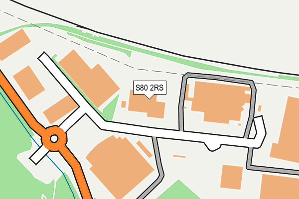
S80 2RS lies on Manton Wood Enterprise Park in Worksop. S80 2RS is located in the Worksop South East electoral ward, within the local authority district of Bassetlaw and the English Parliamentary constituency of Bassetlaw. The Sub Integrated Care Board (ICB) Location is NHS Nottingham and Nottinghamshire ICB - 02Q and the police force is Nottinghamshire. This postcode has been in use since June 1999.


GetTheData
Source: OS OpenMap – Local (Ordnance Survey)
Source: OS VectorMap District (Ordnance Survey)
Licence: Open Government Licence (requires attribution)
| Easting | 461487 |
| Northing | 378379 |
| Latitude | 53.298825 |
| Longitude | -1.078887 |
GetTheData
Source: Open Postcode Geo
Licence: Open Government Licence
| Street | Manton Wood Enterprise Park |
| Town/City | Worksop |
| Country | England |
| Postcode District | S80 |
➜ See where S80 is on a map ➜ Where is Worksop? | |
GetTheData
Source: Land Registry Price Paid Data
Licence: Open Government Licence
Elevation or altitude of S80 2RS as distance above sea level:
| Metres | Feet | |
|---|---|---|
| Elevation | 40m | 131ft |
Elevation is measured from the approximate centre of the postcode, to the nearest point on an OS contour line from OS Terrain 50, which has contour spacing of ten vertical metres.
➜ How high above sea level am I? Find the elevation of your current position using your device's GPS.
GetTheData
Source: Open Postcode Elevation
Licence: Open Government Licence
| Ward | Worksop South East |
| Constituency | Bassetlaw |
GetTheData
Source: ONS Postcode Database
Licence: Open Government Licence
| Prolog (Enterprise Zone) | Manton Wood | 26m |
| Prolog (Enterprise Zone) | Manton Wood | 35m |
| Enterprise Zone (B6040) | Manton Wood | 77m |
| Enterprise Zone (B6040) | Manton Wood | 86m |
| Greencore (Enterprise Zone) | Manton Wood | 106m |
| Worksop Station | 3.2km |
GetTheData
Source: NaPTAN
Licence: Open Government Licence
GetTheData
Source: ONS Postcode Database
Licence: Open Government Licence


➜ Get more ratings from the Food Standards Agency
GetTheData
Source: Food Standards Agency
Licence: FSA terms & conditions
| Last Collection | |||
|---|---|---|---|
| Location | Mon-Fri | Sat | Distance |
| Forest Lane | 17:00 | 10:30 | 1,318m |
| 86 Kingston Road | 17:00 | 11:30 | 1,338m |
| Manton Post Office | 16:45 | 11:30 | 1,717m |
GetTheData
Source: Dracos
Licence: Creative Commons Attribution-ShareAlike
The below table lists the International Territorial Level (ITL) codes (formerly Nomenclature of Territorial Units for Statistics (NUTS) codes) and Local Administrative Units (LAU) codes for S80 2RS:
| ITL 1 Code | Name |
|---|---|
| TLF | East Midlands (England) |
| ITL 2 Code | Name |
| TLF1 | Derbyshire and Nottinghamshire |
| ITL 3 Code | Name |
| TLF15 | North Nottinghamshire |
| LAU 1 Code | Name |
| E07000171 | Bassetlaw |
GetTheData
Source: ONS Postcode Directory
Licence: Open Government Licence
The below table lists the Census Output Area (OA), Lower Layer Super Output Area (LSOA), and Middle Layer Super Output Area (MSOA) for S80 2RS:
| Code | Name | |
|---|---|---|
| OA | E00173383 | |
| LSOA | E01028064 | Bassetlaw 014E |
| MSOA | E02005848 | Bassetlaw 014 |
GetTheData
Source: ONS Postcode Directory
Licence: Open Government Licence
| S80 2QL | Manton Villas | 1134m |
| S80 2QN | Manton Villas | 1173m |
| S80 2QJ | Manton Villas | 1197m |
| S80 2TG | Forest Walk | 1237m |
| S80 2QD | Retford Road | 1256m |
| S80 2TH | Forest Rise | 1268m |
| S80 2QQ | Forest Lane | 1304m |
| S80 2QX | Dukeries Crescent | 1326m |
| S80 2QY | Gorselands Avenue | 1336m |
| S80 2QH | Forest Lane | 1337m |
GetTheData
Source: Open Postcode Geo; Land Registry Price Paid Data
Licence: Open Government Licence