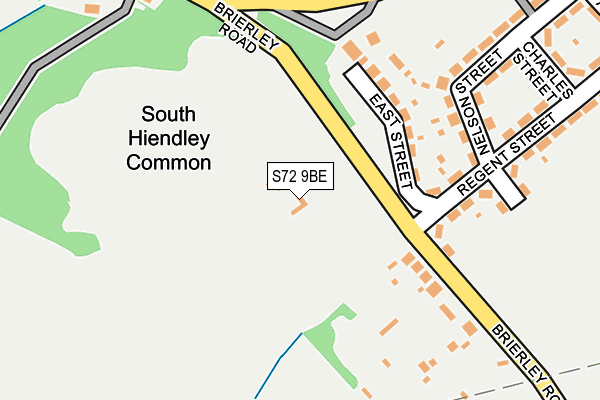
S72 9BE lies on Brierley Road in South Hiendley, Barnsley. S72 9BE is located in the Hemsworth electoral ward, within the metropolitan district of Wakefield and the English Parliamentary constituency of Hemsworth. The Sub Integrated Care Board (ICB) Location is NHS West Yorkshire ICB - 03R and the police force is West Yorkshire. This postcode has been in use since January 1980.


GetTheData
Source: OS OpenMap – Local (Ordnance Survey)
Source: OS VectorMap District (Ordnance Survey)
Licence: Open Government Licence (requires attribution)
| Easting | 440019 |
| Northing | 412187 |
| Latitude | 53.604723 |
| Longitude | -1.396687 |
GetTheData
Source: Open Postcode Geo
Licence: Open Government Licence
| Street | Brierley Road |
| Locality | South Hiendley |
| Town/City | Barnsley |
| Country | England |
| Postcode District | S72 |
➜ See where S72 is on a map | |
GetTheData
Source: Land Registry Price Paid Data
Licence: Open Government Licence
Elevation or altitude of S72 9BE as distance above sea level:
| Metres | Feet | |
|---|---|---|
| Elevation | 80m | 262ft |
Elevation is measured from the approximate centre of the postcode, to the nearest point on an OS contour line from OS Terrain 50, which has contour spacing of ten vertical metres.
➜ How high above sea level am I? Find the elevation of your current position using your device's GPS.
GetTheData
Source: Open Postcode Elevation
Licence: Open Government Licence
| Ward | Hemsworth |
| Constituency | Hemsworth |
GetTheData
Source: ONS Postcode Database
Licence: Open Government Licence
| Regent St East Street (Regent Street) | South Hiendley | 152m |
| Regent St East Street (Regent Street) | South Hiendley | 159m |
| Main St High Street (Main Street) | South Hiendley | 260m |
| Main St High Street (Main Street) | South Hiendley | 275m |
| Regent St Charles Street (Regent Street) | South Hiendley | 316m |
| Fitzwilliam Station | 3.4km |
GetTheData
Source: NaPTAN
Licence: Open Government Licence
GetTheData
Source: ONS Postcode Database
Licence: Open Government Licence


➜ Get more ratings from the Food Standards Agency
GetTheData
Source: Food Standards Agency
Licence: FSA terms & conditions
| Last Collection | |||
|---|---|---|---|
| Location | Mon-Fri | Sat | Distance |
| Brierley Road | 16:00 | 08:00 | 135m |
| 2 Park Avenue | 16:15 | 11:00 | 477m |
| The Common | 16:00 | 09:00 | 489m |
GetTheData
Source: Dracos
Licence: Creative Commons Attribution-ShareAlike
The below table lists the International Territorial Level (ITL) codes (formerly Nomenclature of Territorial Units for Statistics (NUTS) codes) and Local Administrative Units (LAU) codes for S72 9BE:
| ITL 1 Code | Name |
|---|---|
| TLE | Yorkshire and The Humber |
| ITL 2 Code | Name |
| TLE4 | West Yorkshire |
| ITL 3 Code | Name |
| TLE45 | Wakefield |
| LAU 1 Code | Name |
| E08000036 | Wakefield |
GetTheData
Source: ONS Postcode Directory
Licence: Open Government Licence
The below table lists the Census Output Area (OA), Lower Layer Super Output Area (LSOA), and Middle Layer Super Output Area (MSOA) for S72 9BE:
| Code | Name | |
|---|---|---|
| OA | E00059464 | |
| LSOA | E01011784 | Wakefield 040C |
| MSOA | E02002477 | Wakefield 040 |
GetTheData
Source: ONS Postcode Directory
Licence: Open Government Licence
| S72 9BB | East Street | 134m |
| S72 9BD | The Common | 157m |
| S72 9BA | Brierley Road | 160m |
| S72 9AZ | Regent Street | 163m |
| S72 9AY | West Street | 203m |
| S72 9AX | Nelson Street | 242m |
| S72 9AT | Regent Street | 253m |
| S72 9AB | Main Street | 291m |
| S72 9AU | Charles Street | 293m |
| S72 9AS | Regent Street | 347m |
GetTheData
Source: Open Postcode Geo; Land Registry Price Paid Data
Licence: Open Government Licence