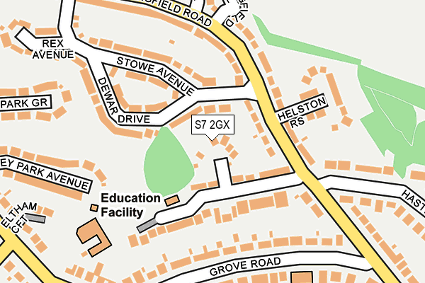
S7 2GX lies on Hastings Mount in Sheffield. S7 2GX is located in the Ecclesall electoral ward, within the metropolitan district of Sheffield and the English Parliamentary constituency of Sheffield, Hallam. The Sub Integrated Care Board (ICB) Location is NHS South Yorkshire ICB - 03N and the police force is South Yorkshire. This postcode has been in use since January 1980.


GetTheData
Source: OS OpenMap – Local (Ordnance Survey)
Source: OS VectorMap District (Ordnance Survey)
Licence: Open Government Licence (requires attribution)
| Easting | 433263 |
| Northing | 383663 |
| Latitude | 53.348835 |
| Longitude | -1.501792 |
GetTheData
Source: Open Postcode Geo
Licence: Open Government Licence
| Street | Hastings Mount |
| Town/City | Sheffield |
| Country | England |
| Postcode District | S7 |
➜ See where S7 is on a map ➜ Where is Sheffield? | |
GetTheData
Source: Land Registry Price Paid Data
Licence: Open Government Licence
Elevation or altitude of S7 2GX as distance above sea level:
| Metres | Feet | |
|---|---|---|
| Elevation | 130m | 427ft |
Elevation is measured from the approximate centre of the postcode, to the nearest point on an OS contour line from OS Terrain 50, which has contour spacing of ten vertical metres.
➜ How high above sea level am I? Find the elevation of your current position using your device's GPS.
GetTheData
Source: Open Postcode Elevation
Licence: Open Government Licence
| Ward | Ecclesall |
| Constituency | Sheffield, Hallam |
GetTheData
Source: ONS Postcode Database
Licence: Open Government Licence
2023 1 NOV £840,000 |
2019 28 JAN £600,000 |
4A, HASTINGS MOUNT, SHEFFIELD, S7 2GX 2017 9 AUG £580,000 |
4, HASTINGS MOUNT, SHEFFIELD, S7 2GX 2016 24 MAY £550,000 |
2012 21 JUN £300,000 |
RANULF, 4A, HASTINGS MOUNT, SHEFFIELD, S7 2GX 2006 6 JUL £530,000 |
RANULF, 4A, HASTINGS MOUNT, SHEFFIELD, S7 2GX 2006 6 JUL £530,000 |
2003 20 OCT £350,000 |
RANULF, 4A, HASTINGS MOUNT, SHEFFIELD, S7 2GX 2002 21 MAY £117,500 |
2002 21 MAY £117,500 |
GetTheData
Source: HM Land Registry Price Paid Data
Licence: Contains HM Land Registry data © Crown copyright and database right 2025. This data is licensed under the Open Government Licence v3.0.
| Stowe Avenue (Springfield Road) | Millhouses | 89m |
| Hastings Road (Springfield Road) | Millhouses | 103m |
| Springfield Avenue (Springfield Road) | Millhouses | 202m |
| Button Hill (Springfield Road) | Millhouses | 410m |
| Glenorchy Road (Carter Knowle Road) | Carter Knowle | 412m |
| Dore & Totley Station | 2.5km |
| Sheffield Station | 4.2km |
GetTheData
Source: NaPTAN
Licence: Open Government Licence
| Percentage of properties with Next Generation Access | 100.0% |
| Percentage of properties with Superfast Broadband | 100.0% |
| Percentage of properties with Ultrafast Broadband | 100.0% |
| Percentage of properties with Full Fibre Broadband | 0.0% |
Superfast Broadband is between 30Mbps and 300Mbps
Ultrafast Broadband is > 300Mbps
| Percentage of properties unable to receive 2Mbps | 0.0% |
| Percentage of properties unable to receive 5Mbps | 0.0% |
| Percentage of properties unable to receive 10Mbps | 0.0% |
| Percentage of properties unable to receive 30Mbps | 0.0% |
GetTheData
Source: Ofcom
Licence: Ofcom Terms of Use (requires attribution)
GetTheData
Source: ONS Postcode Database
Licence: Open Government Licence


➜ Get more ratings from the Food Standards Agency
GetTheData
Source: Food Standards Agency
Licence: FSA terms & conditions
| Last Collection | |||
|---|---|---|---|
| Location | Mon-Fri | Sat | Distance |
| 1 Springfield Avenue | 17:30 | 11:30 | 223m |
| 40 Stowe Lane | 17:30 | 11:30 | 235m |
| Grove Road | 17:30 | 10:00 | 272m |
GetTheData
Source: Dracos
Licence: Creative Commons Attribution-ShareAlike
The below table lists the International Territorial Level (ITL) codes (formerly Nomenclature of Territorial Units for Statistics (NUTS) codes) and Local Administrative Units (LAU) codes for S7 2GX:
| ITL 1 Code | Name |
|---|---|
| TLE | Yorkshire and The Humber |
| ITL 2 Code | Name |
| TLE3 | South Yorkshire |
| ITL 3 Code | Name |
| TLE32 | Sheffield |
| LAU 1 Code | Name |
| E08000019 | Sheffield |
GetTheData
Source: ONS Postcode Directory
Licence: Open Government Licence
The below table lists the Census Output Area (OA), Lower Layer Super Output Area (LSOA), and Middle Layer Super Output Area (MSOA) for S7 2GX:
| Code | Name | |
|---|---|---|
| OA | E00040162 | |
| LSOA | E01007929 | Sheffield 055C |
| MSOA | E02001665 | Sheffield 055 |
GetTheData
Source: ONS Postcode Directory
Licence: Open Government Licence
| S7 2GW | Hastings Road | 59m |
| S7 2GG | Springfield Road | 87m |
| S7 2GF | Springfield Road | 111m |
| S7 2GQ | Dewar Drive | 134m |
| S7 2GP | Stowe Avenue | 151m |
| S7 2GZ | Grove Road | 155m |
| S7 2GL | Helston Rise | 171m |
| S7 2GT | Hastings Road | 190m |
| S7 2GY | Grove Road | 199m |
| S7 2HG | Kingsley Park Avenue | 250m |
GetTheData
Source: Open Postcode Geo; Land Registry Price Paid Data
Licence: Open Government Licence