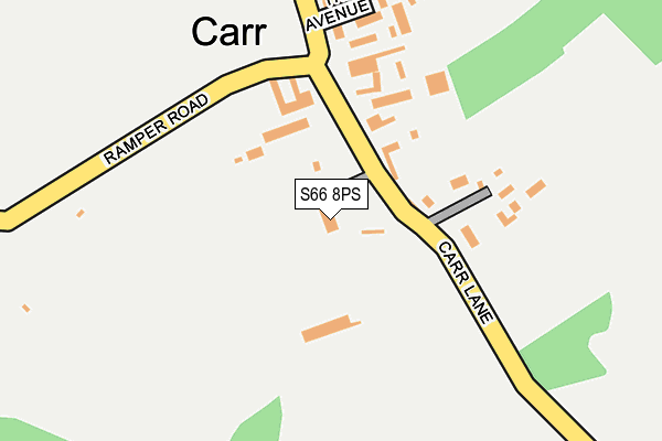
S66 8PS lies on Abbey Glen in Maltby, Rotherham. S66 8PS is located in the Dinnington electoral ward, within the metropolitan district of Rotherham and the English Parliamentary constituency of Rother Valley. The Sub Integrated Care Board (ICB) Location is NHS South Yorkshire ICB - 03L and the police force is South Yorkshire. This postcode has been in use since January 1980.


GetTheData
Source: OS OpenMap – Local (Ordnance Survey)
Source: OS VectorMap District (Ordnance Survey)
Licence: Open Government Licence (requires attribution)
| Easting | 451018 |
| Northing | 390250 |
| Latitude | 53.406629 |
| Longitude | -1.234042 |
GetTheData
Source: Open Postcode Geo
Licence: Open Government Licence
| Street | Abbey Glen |
| Locality | Maltby |
| Town/City | Rotherham |
| Country | England |
| Postcode District | S66 |
➜ See where S66 is on a map ➜ Where is Carr? | |
GetTheData
Source: Land Registry Price Paid Data
Licence: Open Government Licence
Elevation or altitude of S66 8PS as distance above sea level:
| Metres | Feet | |
|---|---|---|
| Elevation | 130m | 427ft |
Elevation is measured from the approximate centre of the postcode, to the nearest point on an OS contour line from OS Terrain 50, which has contour spacing of ten vertical metres.
➜ How high above sea level am I? Find the elevation of your current position using your device's GPS.
GetTheData
Source: Open Postcode Elevation
Licence: Open Government Licence
| Ward | Dinnington |
| Constituency | Rother Valley |
GetTheData
Source: ONS Postcode Database
Licence: Open Government Licence
| Brookhouse Farm (Main Street) | Brookhouse | 1,327m |
| Brookhouse Farm (Main Street) | Brookhouse | 1,336m |
| Newhall Lane (Kingsforth Lane) | Hellaby | 1,482m |
| Sandy Lane (Kingsforth Lane) | Hellaby | 1,494m |
| Steadfolds Rise (Steadfolds Lane) | Thurcroft | 1,529m |
GetTheData
Source: NaPTAN
Licence: Open Government Licence
| Percentage of properties with Next Generation Access | 80.0% |
| Percentage of properties with Superfast Broadband | 0.0% |
| Percentage of properties with Ultrafast Broadband | 0.0% |
| Percentage of properties with Full Fibre Broadband | 0.0% |
Superfast Broadband is between 30Mbps and 300Mbps
Ultrafast Broadband is > 300Mbps
| Percentage of properties unable to receive 2Mbps | 0.0% |
| Percentage of properties unable to receive 5Mbps | 0.0% |
| Percentage of properties unable to receive 10Mbps | 80.0% |
| Percentage of properties unable to receive 30Mbps | 80.0% |
GetTheData
Source: Ofcom
Licence: Ofcom Terms of Use (requires attribution)
GetTheData
Source: ONS Postcode Database
Licence: Open Government Licence


➜ Get more ratings from the Food Standards Agency
GetTheData
Source: Food Standards Agency
Licence: FSA terms & conditions
| Last Collection | |||
|---|---|---|---|
| Location | Mon-Fri | Sat | Distance |
| Carr | 16:00 | 10:30 | 159m |
| Brookhouse | 16:30 | 11:30 | 1,317m |
| Hooton Lane | 16:30 | 11:30 | 1,636m |
GetTheData
Source: Dracos
Licence: Creative Commons Attribution-ShareAlike
The below table lists the International Territorial Level (ITL) codes (formerly Nomenclature of Territorial Units for Statistics (NUTS) codes) and Local Administrative Units (LAU) codes for S66 8PS:
| ITL 1 Code | Name |
|---|---|
| TLE | Yorkshire and The Humber |
| ITL 2 Code | Name |
| TLE3 | South Yorkshire |
| ITL 3 Code | Name |
| TLE31 | Barnsley, Doncaster and Rotherham |
| LAU 1 Code | Name |
| E08000018 | Rotherham |
GetTheData
Source: ONS Postcode Directory
Licence: Open Government Licence
The below table lists the Census Output Area (OA), Lower Layer Super Output Area (LSOA), and Middle Layer Super Output Area (MSOA) for S66 8PS:
| Code | Name | |
|---|---|---|
| OA | E00039468 | |
| LSOA | E01007787 | Rotherham 028A |
| MSOA | E02001605 | Rotherham 028 |
GetTheData
Source: ONS Postcode Directory
Licence: Open Government Licence
| S66 8PW | Carr | 110m |
| S66 8PP | The Avenue | 194m |
| S66 8PT | Newhall Grange | 1168m |
| S25 1YA | 1306m | |
| S66 8RZ | Carr Lane | 1386m |
| S66 8PL | Peak Lane | 1429m |
| S25 1ZG | Mill Close | 1459m |
| S66 9EW | Acre Close | 1524m |
| S66 9JX | Brookhouse Dell | 1556m |
| S66 9EZ | Oak Grove | 1571m |
GetTheData
Source: Open Postcode Geo; Land Registry Price Paid Data
Licence: Open Government Licence