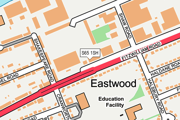
S65 1SH is located in the Rotherham East electoral ward, within the metropolitan district of Rotherham and the English Parliamentary constituency of Rotherham. The Sub Integrated Care Board (ICB) Location is NHS South Yorkshire ICB - 03L and the police force is South Yorkshire. This postcode has been in use since January 1980.


GetTheData
Source: OS OpenMap – Local (Ordnance Survey)
Source: OS VectorMap District (Ordnance Survey)
Licence: Open Government Licence (requires attribution)
| Easting | 443988 |
| Northing | 393779 |
| Latitude | 53.438959 |
| Longitude | -1.339289 |
GetTheData
Source: Open Postcode Geo
Licence: Open Government Licence
| Country | England |
| Postcode District | S65 |
➜ See where S65 is on a map ➜ Where is Rotherham? | |
GetTheData
Source: Land Registry Price Paid Data
Licence: Open Government Licence
Elevation or altitude of S65 1SH as distance above sea level:
| Metres | Feet | |
|---|---|---|
| Elevation | 30m | 98ft |
Elevation is measured from the approximate centre of the postcode, to the nearest point on an OS contour line from OS Terrain 50, which has contour spacing of ten vertical metres.
➜ How high above sea level am I? Find the elevation of your current position using your device's GPS.
GetTheData
Source: Open Postcode Elevation
Licence: Open Government Licence
| Ward | Rotherham East |
| Constituency | Rotherham |
GetTheData
Source: ONS Postcode Database
Licence: Open Government Licence
| Shakespear Road (Fitzwilliam Road) | Eastwood | 107m |
| Cranworth Road (Fitzwilliam Road) | Eastwood | 190m |
| St Johns Road (Fitzwilliam Road) | Eastwood | 276m |
| St Johns Road (Fitzwilliam Road) | Eastwood | 325m |
| Rotherhill Close (Doncaster Road) | East Dene | 395m |
| Rotherham Central Station | 1.6km |
| Meadowhall Station | 5.4km |
GetTheData
Source: NaPTAN
Licence: Open Government Licence
GetTheData
Source: ONS Postcode Database
Licence: Open Government Licence


➜ Get more ratings from the Food Standards Agency
GetTheData
Source: Food Standards Agency
Licence: FSA terms & conditions
| Last Collection | |||
|---|---|---|---|
| Location | Mon-Fri | Sat | Distance |
| Cranworth Road | 16:00 | 12:15 | 144m |
| Eastwood Trading Estate | 16:45 | 11:30 | 320m |
| Milton Road Post Office | 17:15 | 11:45 | 444m |
GetTheData
Source: Dracos
Licence: Creative Commons Attribution-ShareAlike
The below table lists the International Territorial Level (ITL) codes (formerly Nomenclature of Territorial Units for Statistics (NUTS) codes) and Local Administrative Units (LAU) codes for S65 1SH:
| ITL 1 Code | Name |
|---|---|
| TLE | Yorkshire and The Humber |
| ITL 2 Code | Name |
| TLE3 | South Yorkshire |
| ITL 3 Code | Name |
| TLE31 | Barnsley, Doncaster and Rotherham |
| LAU 1 Code | Name |
| E08000018 | Rotherham |
GetTheData
Source: ONS Postcode Directory
Licence: Open Government Licence
The below table lists the Census Output Area (OA), Lower Layer Super Output Area (LSOA), and Middle Layer Super Output Area (MSOA) for S65 1SH:
| Code | Name | |
|---|---|---|
| OA | E00039189 | |
| LSOA | E01007736 | Rotherham 014A |
| MSOA | E02001591 | Rotherham 014 |
GetTheData
Source: ONS Postcode Directory
Licence: Open Government Licence
| S65 1NB | Fitzwilliam Road | 57m |
| S65 1QY | Shakespeare Road | 148m |
| S65 1LP | Halsbury Road | 199m |
| S65 1LN | Cranworth Road | 224m |
| S65 1QA | Fitzwilliam Road | 251m |
| S65 1QU | Bethel Road | 264m |
| S65 1LH | Bowen Road | 274m |
| S65 1RD | Eldon Road | 277m |
| S65 1LW | Coleridge Road | 283m |
| S65 1LR | Haldane Road | 296m |
GetTheData
Source: Open Postcode Geo; Land Registry Price Paid Data
Licence: Open Government Licence