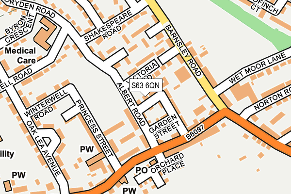
S63 6QN is located in the Hoober electoral ward, within the metropolitan district of Rotherham and the English Parliamentary constituency of Wentworth and Dearne. The Sub Integrated Care Board (ICB) Location is NHS South Yorkshire ICB - 03L and the police force is South Yorkshire. This postcode has been in use since January 1980.


GetTheData
Source: OS OpenMap – Local (Ordnance Survey)
Source: OS VectorMap District (Ordnance Survey)
Licence: Open Government Licence (requires attribution)
| Easting | 442665 |
| Northing | 401156 |
| Latitude | 53.505390 |
| Longitude | -1.358206 |
GetTheData
Source: Open Postcode Geo
Licence: Open Government Licence
| Country | England |
| Postcode District | S63 |
➜ See where S63 is on a map ➜ Where is Wath upon Dearne? | |
GetTheData
Source: Land Registry Price Paid Data
Licence: Open Government Licence
Elevation or altitude of S63 6QN as distance above sea level:
| Metres | Feet | |
|---|---|---|
| Elevation | 40m | 131ft |
Elevation is measured from the approximate centre of the postcode, to the nearest point on an OS contour line from OS Terrain 50, which has contour spacing of ten vertical metres.
➜ How high above sea level am I? Find the elevation of your current position using your device's GPS.
GetTheData
Source: Open Postcode Elevation
Licence: Open Government Licence
| Ward | Hoober |
| Constituency | Wentworth And Dearne |
GetTheData
Source: ONS Postcode Database
Licence: Open Government Licence
| Victoria Road (Barnsley Road) | West Melton | 117m |
| Barnsley Road (Melton High Street) | West Melton | 133m |
| Barnsley Road (Melton High Street) | West Melton | 133m |
| Victoria Road (Barnsley Road) | West Melton | 139m |
| Shakespeare Road (Barnsley Road) | West Melton | 274m |
| Bolton-Upon-Dearne Station | 3.4km |
| Wombwell Station | 4.1km |
| Swinton (South Yorks) Station | 4.1km |
GetTheData
Source: NaPTAN
Licence: Open Government Licence
| Percentage of properties with Next Generation Access | 100.0% |
| Percentage of properties with Superfast Broadband | 100.0% |
| Percentage of properties with Ultrafast Broadband | 100.0% |
| Percentage of properties with Full Fibre Broadband | 100.0% |
Superfast Broadband is between 30Mbps and 300Mbps
Ultrafast Broadband is > 300Mbps
| Median download speed | 40.0Mbps |
| Average download speed | 126.8Mbps |
| Maximum download speed | 350.00Mbps |
| Median upload speed | 0.9Mbps |
| Average upload speed | 3.1Mbps |
| Maximum upload speed | 10.00Mbps |
| Percentage of properties unable to receive 2Mbps | 0.0% |
| Percentage of properties unable to receive 5Mbps | 0.0% |
| Percentage of properties unable to receive 10Mbps | 0.0% |
| Percentage of properties unable to receive 30Mbps | 0.0% |
GetTheData
Source: Ofcom
Licence: Ofcom Terms of Use (requires attribution)
Estimated total energy consumption in S63 6QN by fuel type, 2015.
| Consumption (kWh) | 52,981 |
|---|---|
| Meter count | 6 |
| Mean (kWh/meter) | 8,830 |
| Median (kWh/meter) | 9,028 |
GetTheData
Source: Postcode level gas estimates: 2015 (experimental)
Source: Postcode level electricity estimates: 2015 (experimental)
Licence: Open Government Licence
GetTheData
Source: ONS Postcode Database
Licence: Open Government Licence


➜ Get more ratings from the Food Standards Agency
GetTheData
Source: Food Standards Agency
Licence: FSA terms & conditions
| Last Collection | |||
|---|---|---|---|
| Location | Mon-Fri | Sat | Distance |
| Winterwell Post Office | 17:00 | 10:45 | 241m |
| Masefield Road | 16:00 | 11:00 | 402m |
| Barnsley Road | 16:00 | 11:00 | 448m |
GetTheData
Source: Dracos
Licence: Creative Commons Attribution-ShareAlike
The below table lists the International Territorial Level (ITL) codes (formerly Nomenclature of Territorial Units for Statistics (NUTS) codes) and Local Administrative Units (LAU) codes for S63 6QN:
| ITL 1 Code | Name |
|---|---|
| TLE | Yorkshire and The Humber |
| ITL 2 Code | Name |
| TLE3 | South Yorkshire |
| ITL 3 Code | Name |
| TLE31 | Barnsley, Doncaster and Rotherham |
| LAU 1 Code | Name |
| E08000018 | Rotherham |
GetTheData
Source: ONS Postcode Directory
Licence: Open Government Licence
The below table lists the Census Output Area (OA), Lower Layer Super Output Area (LSOA), and Middle Layer Super Output Area (MSOA) for S63 6QN:
| Code | Name | |
|---|---|---|
| OA | E00038972 | |
| LSOA | E01007693 | Rotherham 001A |
| MSOA | E02001578 | Rotherham 001 |
GetTheData
Source: ONS Postcode Directory
Licence: Open Government Licence
| S63 6QP | Albert Road | 38m |
| S63 6QJ | Co Operative Street | 38m |
| S63 6FF | Victoria Road West | 39m |
| S63 6QH | Co Operative Street | 73m |
| S63 6QL | Garden Street | 76m |
| S63 6DL | Victoria Road East | 84m |
| S63 6QS | Melton High Street | 97m |
| S63 6QX | New Winterwell | 107m |
| S63 6QQ | Melton High Street | 111m |
| S63 6DG | Barnsley Road | 121m |
GetTheData
Source: Open Postcode Geo; Land Registry Price Paid Data
Licence: Open Government Licence