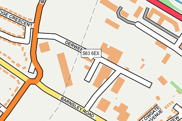
S63 6EX is located in the Hoober electoral ward, within the metropolitan district of Rotherham and the English Parliamentary constituency of Wentworth and Dearne. The Sub Integrated Care Board (ICB) Location is NHS South Yorkshire ICB - 03L and the police force is South Yorkshire. This postcode has been in use since January 1980.


GetTheData
Source: OS OpenMap – Local (Ordnance Survey)
Source: OS VectorMap District (Ordnance Survey)
Licence: Open Government Licence (requires attribution)
| Easting | 442057 |
| Northing | 401892 |
| Latitude | 53.512054 |
| Longitude | -1.367273 |
GetTheData
Source: Open Postcode Geo
Licence: Open Government Licence
| Country | England |
| Postcode District | S63 |
➜ See where S63 is on a map ➜ Where is Wath upon Dearne? | |
GetTheData
Source: Land Registry Price Paid Data
Licence: Open Government Licence
Elevation or altitude of S63 6EX as distance above sea level:
| Metres | Feet | |
|---|---|---|
| Elevation | 30m | 98ft |
Elevation is measured from the approximate centre of the postcode, to the nearest point on an OS contour line from OS Terrain 50, which has contour spacing of ten vertical metres.
➜ How high above sea level am I? Find the elevation of your current position using your device's GPS.
GetTheData
Source: Open Postcode Elevation
Licence: Open Government Licence
| Ward | Hoober |
| Constituency | Wentworth And Dearne |
GetTheData
Source: ONS Postcode Database
Licence: Open Government Licence
| Grove Road (Barnsley Road) | West Melton | 192m |
| Melton Street (Pontefract Road) | Brampton | 239m |
| Grove Road (Barnsley Road) | West Melton | 267m |
| Melton Street (Pontefract Road) | Brampton | 270m |
| Barnsley Road (Grove Road) | West Melton | 275m |
| Wombwell Station | 3.3km |
| Bolton-Upon-Dearne Station | 3.8km |
| Elsecar Station | 4.3km |
GetTheData
Source: NaPTAN
Licence: Open Government Licence
Estimated total energy consumption in S63 6EX by fuel type, 2015.
| Consumption (kWh) | 238,927 |
|---|---|
| Meter count | 9 |
| Mean (kWh/meter) | 26,547 |
| Median (kWh/meter) | 23,279 |
GetTheData
Source: Postcode level gas estimates: 2015 (experimental)
Source: Postcode level electricity estimates: 2015 (experimental)
Licence: Open Government Licence
GetTheData
Source: ONS Postcode Database
Licence: Open Government Licence


➜ Get more ratings from the Food Standards Agency
GetTheData
Source: Food Standards Agency
Licence: FSA terms & conditions
| Last Collection | |||
|---|---|---|---|
| Location | Mon-Fri | Sat | Distance |
| 255 Wath Road | 17:00 | 11:15 | 316m |
| West Mount Avenue | 16:00 | 11:15 | 356m |
| Masefield Road | 16:00 | 11:00 | 625m |
GetTheData
Source: Dracos
Licence: Creative Commons Attribution-ShareAlike
The below table lists the International Territorial Level (ITL) codes (formerly Nomenclature of Territorial Units for Statistics (NUTS) codes) and Local Administrative Units (LAU) codes for S63 6EX:
| ITL 1 Code | Name |
|---|---|
| TLE | Yorkshire and The Humber |
| ITL 2 Code | Name |
| TLE3 | South Yorkshire |
| ITL 3 Code | Name |
| TLE31 | Barnsley, Doncaster and Rotherham |
| LAU 1 Code | Name |
| E08000018 | Rotherham |
GetTheData
Source: ONS Postcode Directory
Licence: Open Government Licence
The below table lists the Census Output Area (OA), Lower Layer Super Output Area (LSOA), and Middle Layer Super Output Area (MSOA) for S63 6EX:
| Code | Name | |
|---|---|---|
| OA | E00038973 | |
| LSOA | E01007695 | Rotherham 001C |
| MSOA | E02001578 | Rotherham 001 |
GetTheData
Source: ONS Postcode Directory
Licence: Open Government Licence
| S73 0XX | Pontefract Road | 223m |
| S73 0XY | Pontefract Road | 243m |
| S63 6DU | Barnsley Road | 244m |
| S63 6DT | Hollowgate Avenue | 250m |
| S63 6PF | Grove Close | 300m |
| S73 0XZ | Moorbridge Crescent | 301m |
| S73 0XG | Wath Road | 306m |
| S63 6PG | Grove Road | 307m |
| S63 6DX | Barnsley Road | 318m |
| S73 0XT | Melton Street | 337m |
GetTheData
Source: Open Postcode Geo; Land Registry Price Paid Data
Licence: Open Government Licence