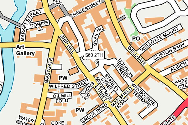
S60 2TH is located in the Boston Castle electoral ward, within the metropolitan district of Rotherham and the English Parliamentary constituency of Rotherham. The Sub Integrated Care Board (ICB) Location is NHS South Yorkshire ICB - 03L and the police force is South Yorkshire. This postcode has been in use since July 1995.


GetTheData
Source: OS OpenMap – Local (Ordnance Survey)
Source: OS VectorMap District (Ordnance Survey)
Licence: Open Government Licence (requires attribution)
| Easting | 442930 |
| Northing | 392647 |
| Latitude | 53.428872 |
| Longitude | -1.355368 |
GetTheData
Source: Open Postcode Geo
Licence: Open Government Licence
| Country | England |
| Postcode District | S60 |
➜ See where S60 is on a map ➜ Where is Rotherham? | |
GetTheData
Source: Land Registry Price Paid Data
Licence: Open Government Licence
Elevation or altitude of S60 2TH as distance above sea level:
| Metres | Feet | |
|---|---|---|
| Elevation | 40m | 131ft |
Elevation is measured from the approximate centre of the postcode, to the nearest point on an OS contour line from OS Terrain 50, which has contour spacing of ten vertical metres.
➜ How high above sea level am I? Find the elevation of your current position using your device's GPS.
GetTheData
Source: Open Postcode Elevation
Licence: Open Government Licence
| Ward | Boston Castle |
| Constituency | Rotherham |
GetTheData
Source: ONS Postcode Database
Licence: Open Government Licence
| Ship Hill (Moorgate Street) | Rotherham Town Centre | 55m |
| Quarry Hill (Wellgate) | Rotherham Town Centre | 113m |
| Unity Place (Westgate) | Rotherham Town Centre | 133m |
| Main Street (Westgate) | Rotherham Town Centre | 162m |
| Doncaster Gate (Wellgate) | Rotherham Town Centre | 168m |
| Rotherham Central Station | 0.5km |
| Meadowhall Station | 4km |
| Darnall Station | 6.2km |
GetTheData
Source: NaPTAN
Licence: Open Government Licence
GetTheData
Source: ONS Postcode Database
Licence: Open Government Licence


➜ Get more ratings from the Food Standards Agency
GetTheData
Source: Food Standards Agency
Licence: FSA terms & conditions
| Last Collection | |||
|---|---|---|---|
| Location | Mon-Fri | Sat | Distance |
| The Crofts | 18:30 | 12:15 | 4m |
| Wellgate Post Office | 18:30 | 12:00 | 143m |
| Rotherham Sso | 19:30 | 12:30 | 171m |
GetTheData
Source: Dracos
Licence: Creative Commons Attribution-ShareAlike
The below table lists the International Territorial Level (ITL) codes (formerly Nomenclature of Territorial Units for Statistics (NUTS) codes) and Local Administrative Units (LAU) codes for S60 2TH:
| ITL 1 Code | Name |
|---|---|
| TLE | Yorkshire and The Humber |
| ITL 2 Code | Name |
| TLE3 | South Yorkshire |
| ITL 3 Code | Name |
| TLE31 | Barnsley, Doncaster and Rotherham |
| LAU 1 Code | Name |
| E08000018 | Rotherham |
GetTheData
Source: ONS Postcode Directory
Licence: Open Government Licence
The below table lists the Census Output Area (OA), Lower Layer Super Output Area (LSOA), and Middle Layer Super Output Area (MSOA) for S60 2TH:
| Code | Name | |
|---|---|---|
| OA | E00168756 | |
| LSOA | E01007714 | Rotherham 017B |
| MSOA | E02001594 | Rotherham 017 |
GetTheData
Source: ONS Postcode Directory
Licence: Open Government Licence
| S60 2DJ | The Crofts | 52m |
| S60 2EY | Moorgate Street | 84m |
| S60 2HG | Ship Hill | 89m |
| S60 2HD | Downs Row | 97m |
| S60 2BZ | Snail Hill | 98m |
| S60 2LR | Wellgate | 106m |
| S60 2DG | Moorgate Street | 116m |
| S60 2DA | Moorgate Street | 117m |
| S60 2DP | Stanley Street | 117m |
| S60 1AP | Westgate | 123m |
GetTheData
Source: Open Postcode Geo; Land Registry Price Paid Data
Licence: Open Government Licence