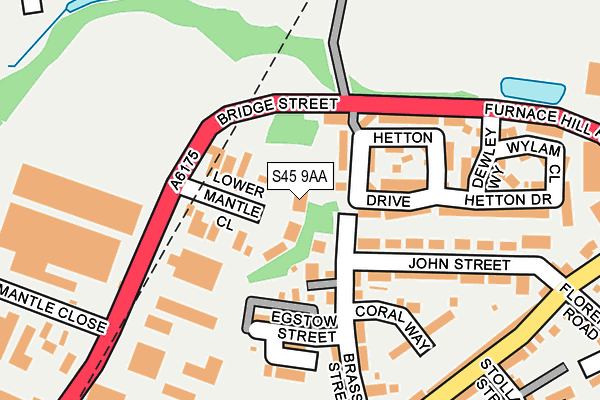
S45 9AA lies on Lower Mantle Close in Clay Cross, Chesterfield. S45 9AA is located in the Clay Cross North electoral ward, within the local authority district of North East Derbyshire and the English Parliamentary constituency of North East Derbyshire. The Sub Integrated Care Board (ICB) Location is NHS Derby and Derbyshire ICB - 15M and the police force is Derbyshire. This postcode has been in use since August 2010.


GetTheData
Source: OS OpenMap – Local (Ordnance Survey)
Source: OS VectorMap District (Ordnance Survey)
Licence: Open Government Licence (requires attribution)
| Easting | 439608 |
| Northing | 363931 |
| Latitude | 53.171044 |
| Longitude | -1.408932 |
GetTheData
Source: Open Postcode Geo
Licence: Open Government Licence
| Street | Lower Mantle Close |
| Locality | Clay Cross |
| Town/City | Chesterfield |
| Country | England |
| Postcode District | S45 |
➜ See where S45 is on a map ➜ Where is Clay Cross? | |
GetTheData
Source: Land Registry Price Paid Data
Licence: Open Government Licence
Elevation or altitude of S45 9AA as distance above sea level:
| Metres | Feet | |
|---|---|---|
| Elevation | 130m | 427ft |
Elevation is measured from the approximate centre of the postcode, to the nearest point on an OS contour line from OS Terrain 50, which has contour spacing of ten vertical metres.
➜ How high above sea level am I? Find the elevation of your current position using your device's GPS.
GetTheData
Source: Open Postcode Elevation
Licence: Open Government Licence
| Ward | Clay Cross North |
| Constituency | North East Derbyshire |
GetTheData
Source: ONS Postcode Database
Licence: Open Government Licence
| Stollard Street (Market Street) | Clay Cross | 271m |
| Community Hospital (Market Street) | Clay Cross | 306m |
| Egstow (Market Street) | Clay Cross | 375m |
| Community Hospital (Market Street) | Clay Cross | 383m |
| Egstow (Market Street) | Clay Cross | 411m |
GetTheData
Source: NaPTAN
Licence: Open Government Licence
GetTheData
Source: ONS Postcode Database
Licence: Open Government Licence


➜ Get more ratings from the Food Standards Agency
GetTheData
Source: Food Standards Agency
Licence: FSA terms & conditions
| Last Collection | |||
|---|---|---|---|
| Location | Mon-Fri | Sat | Distance |
| Bridge Street | 18:30 | 10:30 | 183m |
| Market Street | 16:00 | 09:45 | 481m |
| Coney Green Business Centre | 18:30 | 11:00 | 693m |
GetTheData
Source: Dracos
Licence: Creative Commons Attribution-ShareAlike
The below table lists the International Territorial Level (ITL) codes (formerly Nomenclature of Territorial Units for Statistics (NUTS) codes) and Local Administrative Units (LAU) codes for S45 9AA:
| ITL 1 Code | Name |
|---|---|
| TLF | East Midlands (England) |
| ITL 2 Code | Name |
| TLF1 | Derbyshire and Nottinghamshire |
| ITL 3 Code | Name |
| TLF12 | East Derbyshire |
| LAU 1 Code | Name |
| E07000038 | North East Derbyshire |
GetTheData
Source: ONS Postcode Directory
Licence: Open Government Licence
The below table lists the Census Output Area (OA), Lower Layer Super Output Area (LSOA), and Middle Layer Super Output Area (MSOA) for S45 9AA:
| Code | Name | |
|---|---|---|
| OA | E00100059 | |
| LSOA | E01019775 | North East Derbyshire 012B |
| MSOA | E02004116 | North East Derbyshire 012 |
GetTheData
Source: ONS Postcode Directory
Licence: Open Government Licence
| S45 9NJ | Egstow Street | 116m |
| S45 9TU | Hetton Drive | 138m |
| S45 9NH | Brassington Street | 147m |
| S45 9TT | Bridge Street | 153m |
| S45 9TG | Hetton Drive | 193m |
| S45 9NQ | John Street | 210m |
| S45 9NU | Bridge Street Industrial Estate | 239m |
| S45 9TN | Furnace Hill Road | 241m |
| S45 9TH | Dewley Way | 249m |
| S45 9NB | Market Street | 272m |
GetTheData
Source: Open Postcode Geo; Land Registry Price Paid Data
Licence: Open Government Licence